
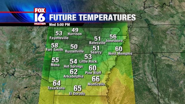
A warm front will push in from the South during the early afternoon with showers and isolated thunderstorms. This front will stall out across Central Arkansas with warmer temperatures across Southern portions of the State and cooler temperatures North. Temperatures across Southern Arkansas will warm well into the 60s, with 50s just North of the front. Below are computer projected temperatures for 5 PM Wednesday.
A cold front will approach during the evening with showers and few storms. Severe weather is unlikely, although a couple of stronger storms may be briefly capable of producing small hail. As of early Wednesday morning, the Storm Prediction Center does not include any part of Arkansas in a risk area for severe weather

The main threat from stronger storms will be hail, but an isolated strong wind gusts may also be possible. The tornado threat for Arkansas is minimal with this system. Most showers and remaining storms will push out of Central Arkansas by 9 PM
No comments:
Post a Comment