Thursday evening a deep trough will swing through the Mississippi Valley creating a surface low in the Mid-West. Underneath this low will be a fairly strong cold front. Once the cold front slips down to our neighborhood there is a slim chance that severe weather will break out near the southeast corner of the state.
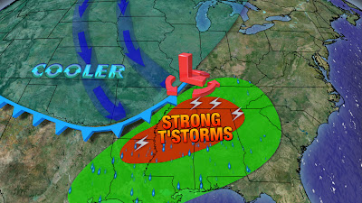
Luckily we'll have an inversion of warm air aloft that will make it hard for thunderstorms to form in Central Arkansas. Southeast Arkansas may not be so lucky and will need to be evaluated for Thursday evening.

As of right now all of the computer models suggest that the storms will not develop until they are well south of Arkansas. Our computer model at FOX 16 is on the same page as every other weather model out there. Of course, these are just computer models and they typically struggle with surface based convection (i.e. storms development) which is the type of convection we would be looking at on this day.

If these storms do manage to develop, we are looking at the possibility of tornadoes, large hail and gusty winds.
We'll stay on top of this developing story and let you know the latest on FOX 16.
No comments:
Post a Comment