Saturday, April 30, 2011

From Tornado Threats to Flooding Issues...

Is there anything Mother Nature won't throw at us? 

After the NWS went through all the storm damage, they found 11 tornadoes between Monday and Tuesday's storms.  The worst tornado was the one that hit Northern Pulaski County and pushed all the way through Vilonia.


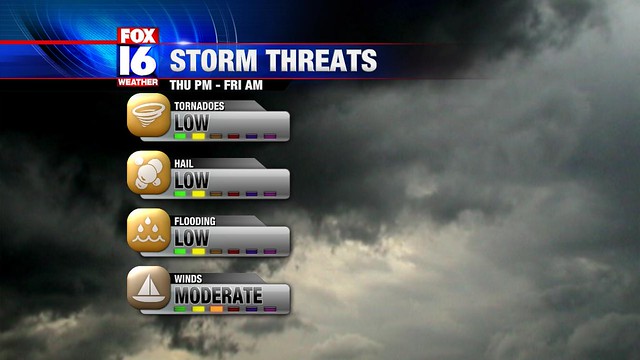
With that mess out of the way we still have another threat looming on top of us and that is...flooding.  As I'm writing this discussion a long line of storms is slowly parading around the Little Rock area.  Already we're getting reports of flooded roadways.  This will be a common theme until the storms wind down midway through the work week.

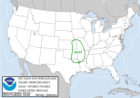
So the million dollar question is where will it flood?  Well based on the latest model outputs it suggests that major flooding will near the White/Black River since it is already cresting around its bank.  As for the Arkansas River, we'll see if it can withhold the onslaught of rain coming this way.  There are no guarantees.  Be sure to be ready of a flood if you live near a creak or a major river.

Why is this happening?  Well, a cold front is going to move at an incredibly slow pace and interact with plentiful moisture at the surface.  The front won't clear the state until TUESDAY (that's one slow cold front).  With the slow pace and abundant moisture set in stone, we're looking at the possibility of a half foot of rain or possibly more in localized spots.

                                                 (one weather model shows up to 7"+ of rain in Little Rock)

The rain will diminish early on Tuesday morning and we'll stay dry the rest of the work week.  There are some signs of a quick shower over the weekend but we'll worry about that when the time comes.  For now be safe and please DON'T DRIVE OVER FLOODED ROADWAYS.

Sunday, April 24, 2011

Violent Weather Monday...and Tuesday Night

As I write this discussion in the middle of the night, there is a large cluster of showers and strong thunderstorms roaming around I-40.  Worst threats will continue to be gusty straight line winds and lots of lightning.  Little Rock could receive a quick heavy dose of rain after midnight.

MONDAY:  Jeff and I agree that this day will be a SWAD (Severe Weather Alert Day).  The jet stream will buckle and allow a surface low to pull a cold front into the western border of Arkansas.  Before this occurs, we'll have lingering showers and storms in portions of Central and Northern Arkansas in the morning.  Eventually we'll dry out around the lunch hour...but by the time we reach the mid-afternoon hours violent storms should erupt on the eastern side of Oklahoma and NE Texas.  These supercell thunderstorms are expected to track over in Western Arkansas around 3-5pm.  At this point, large tornadoes and big hail will be the main concern.  As the strong storms advance forward toward Central Arkansas they'll likely form into a line around 8-10pm.  The main threat will quickly shift from tornadoes to straight line winds.  The whole severe weather episode should diminish as we get past the midnight period.


                                       (Weather model shows storms developing around 3-4pm)


                                            (Model shows rough weather around 8pm)


On top of all this mess, the National Weather Service is very worried about the potential for major floods in Northern Arkansas.  In fact, the service are calling this threat a "particularly dangerous situation".  I've never, ever seen that type of wording ever used with floods.  So, be extremely wise with your travel near I-40 and northward.  If emergency personal ask you to leave your home due to flood waters make sure to listen to them and follow their instructions.

TUESDAY: If you thought it couldn't get any worst, we have a second round of severe weather primed and ready for Tuesday night and early Wednesday morning.  What's sad is that it could be even worst.  The flood waters could be higher and...the potential for long lived tornadoes will be greater.  Luckily we'll have a small window of opportunity for our weather to actually calm down.  We should relatively dry most of Tuesday morning and afternoon yet when another intense surface low heads into town  we could be looking another bad episode of severe weather.

Our weather will FINALLY settle down Thursday and Friday.  Until then be sure to stay tuned to FOX 16 for breaking weather news.  We'll be sure to stream our severe weather coverage online and on mobile phones so have those handy in the future.  Also you can follow me on twitter at FOX16weather.

Have a great week and be safe!

Saturday, April 23, 2011

Warm & Humid for the Weekend...

The weather is certainly not as active like we had earlier in the week.  Here is quick review of what will occur in the next few days.

TODAY: Thunderstorms will continue to roam around the northern border of Arkansas near the stationary front.  At the same time, in central Arkansas we'll feel a breezy wind and muggy air return to the region.  There will be moments where you'll make out some sunshine but won't be for an extended period of time.  In addition to these conditions, temperatures will be in the 80's this afternoon.

EASTER SUNDAY:  Mother Nature will provide almost the exact same weather pattern.  Majority of the storms will be north of I-40 while other parts of Arkansas will enjoy a breezy, warm day with temperatures surging to the 80's.  A few showers may finally reach central Arkansas later in the evening and overnight hours.

NEXT WEEK:  Get ready for a soggy and wet start to the week.  A cold front will sag back into Central Arkansas as we get into Monday and Tuesday.  This event will setup the stage where a few strong thunderstorms could exist.  At this time, hail and weak tornadoes are the worst threats.  The worst day looks to be Wednesday.  By this time an intense surface low will develop right in our backyard in Arkansas.  With the winds spinning with height and a great supply of moisture we could be looking at several tornadoes on that day.  We'll have to wait and see if the models verify on this setup.

We'll have more updates on the blog later this weekend.  Until then have a great Easter and enjoy the weather.

Tuesday, April 19, 2011

Severe Weather Possible Later Today


Today is a Severe Weather Alert Day. Strong thunderstorms will erupt late this afternoon and evening. Then they will progress through parts of Central Arkansas during the overnight hours. More details are revealed in the video above.

If we do have severe weather coverage this evening we'll make sure that it will be streamed online for our audience. This content maybe seen on your smart phone as well so if you loose power you'll still be able to watch our broadcast.

Be safe and have a wonderful Tuesday.

Monday, April 18, 2011

Tornado Outbreak Ravages Southeast

                                     (video of large tornado ripping through downtown Raleigh, NC)

What was a weak area of low pressure became a violent storm system for the Deep South. Over 250 reports of tornadoes were found in U.S. the last several days. Yesterday, the National Weather Service in Arkansas declared two more tornadoes did touch down early Friday morning. One on the eastern edge of Saline County and the southern tip of Pulaski County.  The other tornado was confirmed in Yell County.

Lately our weather has calmed down and been pretty nice, but the weather is shifting to a more active pattern.  I'll have a video post up later today explaining the situation.

Thursday, April 14, 2011

Storms With Gusty Winds Tonight


Here is a quick video recapping the event that will occur tonight.  I'll discuss next week's weather after the line of storms push through Arkansas.

Wednesday, April 13, 2011

Spectacular Weather is Going Away

Soak it up as much as you can today because from here on out things won't be the same for the next few days.

TODAY: The rest of this afternoon and evening will be very nice.  Temperatures will continue to hover in the upper 70's and flirt with 80 degrees while the sunshine will beam overhead.

TONIGHT:  Our thermometers will only slip down to the low 60's/upper 50's.  Meanwhile we'll see an increase in cloud cover.


THURSDAY: As we discussed earlier, a steep change in low pressure will occur in East Kansas.  Inevitably this change will bring in breezy winds and warmer temperatures near 80 degrees in Little Rock.  Later toward the evening we'll watch thunderstorms blossom near the low and along a developing cold front to the south.  These intense storms will be capable of producing fairly large tornadoes and golf ball size hail.  Luckily these damaging thunderstorms will likely affect Northeast Oklahoma and East Kansas (hence the moderate outlook from SPC).  The northwest tip of Arkansas may see storms drift into their neighborhood but they should loose some of their intensity.  Eventually, more thunderstorms will erupt and form into a line later Thursday night.  This batch of rain and lightning won't be nearly as bad as what we expect in NE Oklahoma.  At this point the best timing for these storms will be around midnight or a couple hours earlier.


FRIDAY: We'll dry out during the day and feel temperatures stay in the upper 60's.

WEEKEND: Latest indications reveal a relative mild weekend with temperatures struggling to get to 60 on Saturday and getting close to 70 on Sunday.  Sunshine will be prevalent as well with a light breeze on Saturday.

In the next blog entry I'll talk about next week's weather pattern in more detail.  Until then I love your faces and have a wonderful Tuesday.

Tuesday, April 12, 2011

Another Gorgeous Spring Day

TODAY: I don't know how many of these great weather days we have left this spring, but I know that I love them.  Temperatures are already sitting pretty in the low to mid 70's with abundant sunshine and calm winds.  We'll keep these conditions going when you come back from work later today.

TONIGHT:  The weather will be mostly clear and quite chilly for this time of year.  Thermometers will sink down to the upper 40's so think twice before you open those windows before you go to bed.

TOMORROW: More wonderful weather on tab.  We'll receive another full dose of sunshine with hardly a cloud in the sky.   Temperatures will be slighty warmer with high's generally in the upper 70's.

REST OF THE WEEK: A very strong area of low pressure will form in the Central Plains late Thursday evening.  This feature will spawn a cold front and, eventually, strong thunderstorms.  The Storm Predicition Center in Norman is already on top of this and has Western Arkansas in a slight risk area (aka thunderstorms could turn severe).  Judging by the latest model data, the worst threat for damaging winds, hail and tornadoes appear to be in the Eastern Kansas/Western Missouri border.  Still we could see one or two nasty storms break out in Western Arkansas on Thursday evening...that is...if they managed to develop that quickly.  Most computer models (the more reliable ones anyway) are suggesting another overnight episode that we had early on Monday morning.  In this case, the thunderstorms most likely won't get here until midnight or early on Friday morning.  If this scenario turns out to be true then all we would have to worry about is damaging straight line winds and small hail.


We're still collecting data about this rapidly developing system.  We'll let you know more in the coming blog entries.

We'll dry out by Friday afternoon and feel temperatures plunge into the 60's.

WEEKEND:   We'll be into a dry pattern with a good supply of sunshine.  Otherwise, temperatures will stay in the 60's for the most part.

NEXT WEEK: Majority of the models are in agreement that a broad upper level trough will sink down into the Central/Southern Plains and stay there for a lengthy period.  In other words, we'll go through a wetter pattern with a series of showers and thunderstorms moving in the state.  Temperatures will be on par but not exceptly warm most likely in the 70's.

Sunday, April 10, 2011

Cool Front Not Cold Front

Today is almost a carbon copy of yesterday.  Temperatures will be slightly cooler than Saturday and the winds will be faster but other than that there isn't a huge difference outside.

TONIGHT:  The rest of the tonight appears a bit breezy and warm with temperatures staying well into the 70's.  On top of that, clouds will be on the increase.

MONDAY:  A little past midnight, a cold front will cross through our northwest border.  With enough convergence and cool air aloft we'll see strong thunderstorms fire off this frontal boundary.  Eventually these storms will form into a disorganized line and move though Central Arkansas around sunrise or possibly sooner.  Looking at the latest observations and model data I can make out a good amount of wind energy coming out of this upcoming system.   In other words, damaging straight line winds are on the menu with these storms along with frequent lightning and heavy downpours.  Hail could also come into play in few parts of the state.  When it comes to the tornado threat...well...it's there but it's not very high.  The instability seems incredibly low for a large tornado to break out into the state.  Like I mentioned yesterday, I still can't rule out a small weak tornado dropping somewhere due to the low level rotation.

When most of you get up and go to work you'll be driving through puddles and light showers.  Most of the thunderstorms will have already pass you by and head over the eastern portion of the state.  It will be cloudy and damp in the morning with temperatures generally in the 60's.  In due time, the clouds should clear out in the afternoon hours and allow thermometers to spike up back into the low to mid 70's.

REST OF THE WEEK:  We'll stay comfortable in the 70's for a couple days and see plenty of sunshine.  As we close out the work week more clouds will pay us a visit and possibly drop some heavy rain in Northern Arkansas as we approach Thursday.  An upper level disturbance will hang around just to our north then track over to the east allowing northwest flow to return to the state.  This pattern change will allow cool air to rush into the Natural State and hold temperatures in the 60's by the time we approach next weekend.

Saturday, April 9, 2011

Hot Temperatures in April?

Even though I'm away in Houston, I can tell you that it is on the verge of being hot in Little Rock and most of Arkansas.  Temperatures across the state range from the upper 80's and low 90's.  With that being said, the hot stuff won't stick around much longer.

TONIGHT: Temperatures will gradually fall to the 70's and upper 60's while a few clouds passing by the state. It certainly won't be window-opening weather but at least we'll cool down to a fairly comfortable level.

TOMORROW:  The rest of the weekend will be breezy and very warm with high's flirting with the mid 80's.   Winds will occasionally pick up near 30 mph.  On top of that we'll see a mixture of clouds and sunshine.

SUNDAY NIGHT - EARLY MONDAY:  A cold front will barrel through Arkansas just a little past midnight.  Besides cooler air, the front will carry a disorganized line of thunderstorms through the state.  Some of these storms will be capable of bringing gusty winds and small hail (I know, I know most of the storms in the spring do that).  After reviewing the helicity and instability values it seems like the tornado threat again will be low.  That doesn't mean a quick small tornado won't form but the chances of the huge destructive one will be very rare with this setup.

EARLY NEXT WEEK:  The weather will be cooler in the 70's with a healthy supply of sunshine.  More wet weather may arrive later in the week but I'm not completely sold on that idea just yet.

That's it for today.  Have a wonderful weekend.

Thursday, April 7, 2011

Gloomy Sight Replaces Sunshine


Here is a quick sample of the webcast we'll be posting on the FOX 16 website on a fairly regular basis.  This video does include the forecast for this evening.

FORECAST FOR THE NEXT FEW DAYS

TOMORROW: Clouds will stick around the first half of your Friday but will eventually break up and reveal more sunshine in the afternoon hours.  Temperatures will gradually warm up to the low to mid 80's.   I'm sure that will be a treat.  In addition to the warmth we'll have our humidity spike up.   A few models are showing a couple showers crossing our western border by late Friday evening but that scenario seems far fetched at this point.

THE WEEKEND: We'll get a nice blend of clouds and sunshine while temperatures hover in the 80's.  Breezy winds will be factor on Sunday with a strong low developing over to our northwest.  As the low pressure system travels eastward, it will carry a cold front underneath it.  This front will visit Arkansas late Sunday night and into the wee hours of Monday morning.  Of course, with the front pressing through we'll have thunderstorms slam the region.  Judging by the latest model parameters and timing of the event were looking at gusty straight line winds and small hail out of these storms.  Again, the tornado threat will be fairly low.

That is it from the weather center.  Make sure to watch Chief Meteorologist Jeff Baskin this evening at 5, 5:30, 9 and 10pm.

Tuesday, April 5, 2011

We're in HD!


It is official. Fox 16 News will be in High Definition tonight!  From the weather side of things, that means completely brand new content from your favorite weather team.  I know what you're thinking...how will this change from the content you saw yesterday or the past several years?

Clarity- When switching over to HD we were able to capture images and create maps with stunning detail unlike anybody has seen in Little Rock.  If you don't believe me just watch our newscast tonight. You'll actually be able to see what is going in your neighborhood with incredible street level mapping.

Best Severe Weather Tools - Jeff and I searched high and low to find the best severe weather tools on the market and we found it.  In the future we'll show you where the greatest potential for hail and tornadoes will be inside of a storm.  Plus, we have a new storm tracking tool that makes it easier to understand.

Interactive - From now on we can physically interactive with the data that is behind us.  This may not sound like much but it's a huge leap forward for us in the weather center.  We'll demonstrate it almost every single day so check it out.

New Content - For the first time you'll see lightning data on the web. We've got a 3-D model of downtown Little Rock that is jaw dropping.  Not to mention we have new 3-D maps that are simply amazing.  We just can't wait to show you all of it.

http://www.fox16.com/content/hd/default.aspx

Alright, you've just been filled in with this awesome news.  Now in terms of the blog we'll be upgrading it as well.  Look for a new video coming out later this afternoon.

Monday, April 4, 2011

Calm Weather...Exciting News Coming

TONIGHT: After a long day at work, the weather in Arkansas is calming down.  A vigorous cold front passed through the state prompting intense thunderstorms.  Many of them produce gusty straight line winds which did cause damage in the southern portion of the state.  Luckily we were able to avoid the tornado threat out of the event.  Through the rest of the night we'll quickly cool off to the 40's and upper 30's while underneath a mostly clear sky.


TOMORROW:  As much as you hate using your fireplace/furnace in the morning, temperatures will quickly rebound to the 60's by Tuesday afternoon.

REST OF THE WEEK: Not much going on in our atmosphere through the work week.  A deep trough will develop in the western part of the country.  Meanwhile back in Arkansas we'll gladly take the southwest flow ahead of the trough and warm up steadily into the 70's and 80's.

NEXT BEST CHANCE OF RAIN? Sunday PM-Monday...Both long term models show another cold front visiting the state around this period which should increase our rain chances.  Hard to say if we'll see another dose of strong thunderstorms.


LAST BUT NOT LEAST...WE HAVE EXCITING NEWS TO SHARE WITH YOU IN THE NEXT BLOG, SO BE SURE TO STAY TUNED.

Sunday, April 3, 2011

Strong Storms and Cooler Weather Ahead

TODAY: You could bust out the sunglasses and saddles if you like.  Temperatures are well into the mid 80's and should stay here for the next couple hours.  Meanwhile we have an annoying southwest wind that has reached 30 mph at times.  Oh well, I guess it is a fair trade to get the warm air in place.

TONIGHT: Thanks to low level moisture and lift, we'll see an increase in cloud cover.  Otherwise the breezy winds will help temperatures stay in the 70's most of the night.

TOMORROW:  As I mentioned in the last blog post, a strong cold front will dive through Arkansas.  This event will lead to a fairly odd forecast.  In the morning we'll have our warmest temperature of the day near 70 degrees.  As the frontal boundary sweeps through late in the morning and the early afternoon hours we'll watch a line of thunderstorms barrel through our region.  The worst threats continue to be damaging straight line winds, hail and a small risk of a brief tornado.  Once we're well behind the front we'll steadily cool off to the 60's and eventually the mid 50's by the late afternoon hours.  Meanwhile we'll see a mostly cloudy sky.

TUESDAY: I'm sure everybody is going to be talking about how cold it will be in the morning.  If everything goes as planned, we will see our thermometers plummet to the upper 30's when you go out to work Tuesday morning.  In the northwest corner of the state they could even see frost.  Of course, temperatures won't stay there for very long.  With a good dose of sunshine we'll climb out of the 30's and jump back to the low to mid 60's by the afternoon.

REST OF THE WEEK:  More clouds will show up on our doorstep but a persistent south-southwest flow we'll force temperatures to make their way back to the 70's and 80's.  If you're wondering about our next big rain maker...well...you might have to wait a while.  Long term model runs reveal hardly any triggering mechanisms out there for thunderstorms.  There maybe a few isolated showers in Northern Arkansas by Friday but I wouldn't hold my breath on that coming true.

Saturday, April 2, 2011

Gorgeous Weather Leaving Soon

Today will be one of the best weather days of the year.  After a very chilly morning, our weather will become picture perfect later on.  Our winds will be light and variable while temperatures spike up to the mid 70's.  At the same time, sunshine will dominate the Arkansas sky.

TOMORROW: Of course Mother Nature has a cruel sense of humor.  Tomorrow appears to be a little less ideal.  A strong area of low pressure will take shape across the Northern Plains.  As it grows stronger tomorrow afternoon, the winds in Arkansas will ramp up between 15-25 mph with gusts approaching 30-35 mph.  Since dry vegetation remains fairly common across the state there is a concern for grass fires.  Hopefully the increasing low level humidity will limit or cap the amount seen in our region.

If it wasn't for the fast winds, Sunday wouldn't be a bad day.  Temperatures will surge to the low to mid 80's while more sunshine returns to the state.


MONDAY: The strong low pressure system that sweeps through the Northern Plains will rush to the Great Lakes region.  Underneath it, there will be a potent cold front barreling through mid-section of the country. The front should be marching through Central Arkansas late Monday morning and be out of here by the late afternoon hours.  It is highly likely that a line of storms will accompany this front.  The biggest concern about Monday revolves around the exact intensity of the thunderstorms.  At this moment, the limited instability and  low level helocity shown by the latest computer models leads me to believe that the tornado threat looks VERY LOW.  Meanwhile, gusty straight-line winds and large hail are still on the table especially for Southeast Arkansas.


 THE REST OF THE WEEK:  When we fall behind the front on Tuesday it will be a rude awaking.  By Tuesday morning it will be downright cold and into the mid upper 30's (YIKES!), so don't put away the winter coats just yet.  In Northern Arkansas there could even be some frost as temperatures flirt with the freezing marker.  Don't worry though, we'll rebound to the 60's before you know it.  We'll stay in the 70's for the rest of the work week with increasing cloud cover by Friday.  A few weak upper level disturbance may set off a couple showers by Friday and early next weekend but it's too soon to tell if it is a guarantee at this point.

Friday, April 1, 2011

We're Back!


 It's so good to see your faces again.  If you haven't noticed, we have not been updating the blog recently.  Of course, there is a reason for the lack of updates. We've been working hard on bringing new content.  We can't tell you what it is but rest assured it will be amazing.

Anyways, if you're wondering about what the weather will do in Arkansas then click on the video above and enjoy.  Have a wonderful weekend.