Friday, June 29, 2012

More Heat for the 4th

The brutal heat wave we experienced this week was unbelievable.  Three days out of the work week feature temperatures at or above 105°.  This kind of heat has left many to wonder will it ever cool off? Better yet, will it cool off in time for the 4th of July?


The short answer is NOT LIKELY.  Sure temperatures will drop a couple degrees but it won't feel that different outside.  The upper level pattern will be about the same.  The intense high pressure system aloft will slightly weaken next week causing temperatures to drop down to 100°.

As you can make out in the image above, the jet stream will remain well out to our north and there seems to be no tropical activity to speak of in the Gulf or Atlantic.  In essence, the 4th of July appears dry and very hot.

                                                  (GFS model showing rain coming Thursday night.)

There is some promise of an isolated rain shower coming in one week from now but that seems like wishful thinking at this point.  We'll wait and see if more models are on board with this idea.

Until then be careful outside and try to stay cool.  Don't forget we have burn bans across all of our viewing area so you can't light any fireworks without special permission.

Thursday, June 28, 2012

All Time Record Heat for June

Record temperatures were smashed across Arkansas Thursday as temperatures soared well past the 100 degree mark. Some spots set a new record for the hottest temperature ever recorded in the month of June. Little Rock hit 107, breaking the record high for the month of 105, which was recently tied on Monday. Harrison broke the record for the month with 107, beating out the old record of 105 set in 1936. North Little Rock tied the record high for the month with a high of 105. This tied the record which was just set on Monday June 25th. Many other locations set record highs for the day. Below is a list of high temperatures across Arkansas from The National Weather Service in Little Rock.

...MANY LOCATIONS TOP THE CENTURY MARK THIS AFTERNOON...

MANY LOCATIONS ACROSS THE LITTLE ROCK COUNTY WARNING AREA REACHED OR
IN SOME CASES...EXCEEDED THE CENTURY MARK MONDAY AFTERNOON. THE
FOLLOWING IS A LIST OF OFFICIAL REPORTING STATIONS THAT HAVE
ECLIPSED 100 DEGREES AS OF THIS TIME WITH MANY STATIONS SETTING
RECORD HIGHS FOR THE DAY.

TEMPERATURES OVER 100 DEGREES ON JUNE 28TH
-----------------------------------------------

EVENING SHADE.......................111 DEGREES
MOUNTAIN HOME.......................109 DEGREES
BLANCHARD SPRINGS...................109 DEGREES
GUY.................................109 DEGREES
RUSSELLVILLE........................109 DEGREES
SEARCY..............................109 DEGREES
COMPTON.............................108 DEGREES
BATESVILLE APT......................108 DEGREES
FLIPPIN.............................108 DEGREES
CLINTON.............................108 DEGREES
LITTLE ROCK ADAMS FIELD.............107 DEGREES
HARRISON............................107 DEGREES
BOONEVILLE..........................107 DEGREES
JACKSONVILLE AFB....................107 DEGREES
NORTH LITTLE ROCK...................105 DEGREES
SHERIDAN............................105 DEGREES
ARKADELPHIA.........................105 DEGREES
HOT SPRINGS APT.....................105 DEGREES
MENA................................104 DEGREES
JESSIEVILLE.........................104 DEGREES
MONTICELLO..........................104 DEGREES
PINE BLUFF AIRPORT..................103 DEGREES
HECTOR..............................103 DEGREES
ODEN................................103 DEGREES
STUTTGART...........................102 DEGREES
CAMDEN..............................102 DEGREES
NEWPORT.............................101 DEGREES
MOUNT IDA...........................101 DEGREES
BEEDEVILLE 4 NE.....................100 DEGREES

ALL-TIME RECORDS SET THIS AFTERNOON IN ARKANSAS
-----------------------------------------------

*107 DEGREES AT LITTLE ROCK ADAMS FIELD SETS THE ALL TIME HIGH
TEMPERATURE RECORD FOR THE MONTH OF JUNE. THE PREVIOUS RECORD WAS
105 SET ON JUNE 25TH OF 2012...JUNE 29TH OF 1988 AND JUNE 20TH OF
1936.

*107 DEGREES AT HARRISON SETS THE ALL TIME HIGH TEMPERATURE RECORD
FOR THE MONTH OF JUNE. THE PREVIOUS RECORD WAS 105 DEGREES ON JUNE
20TH OF 1936.

*105 DEGREES AT NORTH LITTLE ROCK TIED THE ALL TIME RECORD HIGH
TEMPERATURE FOR THE MONTH OF JUNE. THE OTHER TIME 105 DEGREES WAS
HIT AT NORTH LITTLE ROCK WAS EARLIER THIS MONTH...ON THE 25TH OF
JUNE.

Wednesday, June 27, 2012

Oppresive Heat

After the record setting heat on Monday you would think Mother Nature would lay low and back off on the intense heat.  Well, think again.  Instead of the heat going down, it looks like Mother Nature is going to crank it back up.


A strong ridge of high pressure is expected to grow in size and smother the midsection of the U.S. in the next few days. As the upper air pressure increases and expands, the air underneath it will heat up quickly.  Thus, our surface temperatures will reach the triple digits for an extensive period of time.


How long will this heat machine last? Early indications show the high pressure breaking down a little as we approach next week.  In other words, the thermometers could move down a couple degrees but they won't be that far away from the century mark.

So stock up on the water bottles and try to stay inside with the A/C blasting.  This could be the start of a very long summer.


Tuesday, June 26, 2012

Record Heat Engulfs Arkansas

Blazing heat smashed temperature records across Arkansas Monday afternoon. Many locations not only set record highs for the day, but also approached record highs for the entire Month of June. Little Rock tied the all time record high for June at 105 degrees, previously set on June 20th 1936.


North Little Rock also set a record high for the month of June at 104 degrees, breaking the old record of 102 set on June 29th 1988. Hot Springs smashed the record high of 100 with an actual high of 107 this afternoon. Below is a list of places in Arkansas that broke the 100 degree mark Monday.

RUSSELLVILLE........................109 DEGREES
GUYS RAWS...........................108 DEGREES
CLINTON.............................106 DEGREES
JESSIEVILLE.........................106 DEGREES
EVENING SHADE (SHARP COUNTY) RAWS...106 DEGREES
ARKADELPHIA.........................106 DEGREES
MENA................................106 DEGREES
LITTLE ROCK AIR FORCE BASE..........106 DEGREES
BOONEVILLE RAWS.....................105 DEGREES
ODEN RAWS...........................105 DEGREES
LITTLE ROCK ADAMS FIELD.............105 DEGREES
NORTH LITTLE ROCK...................105 DEGREES
SHERIDAN RAWS.......................105 DEGREES
SEARCY..............................105 DEGREES
BLANCHARD SPRINGS RAWS..............105 DEGREES
ARMSTEAD MOUNTAIN RAWS..............104 DEGREES
CAMDEN..............................104 DEGREES
HOT SPRINGS.........................104 DEGREES
FLIPPIN.............................104 DEGREES
MOUNTAIN HOME.......................104 DEGREES
MOUNT IDA...........................103 DEGREES
BATESVILLE..........................102 DEGREES
HARRISON............................102 DEGREES
DEVILS KNOB RAWS....................101 DEGREES
MONTICELLO..........................100 DEGREES
COMPTON RAWS........................101 DEGREES
NEWPORT.............................100 DEGREES
PINE BLUFF..........................100 DEGREES


A weak cold front slides through early Tuesday morning, which will bring slightly cooler in for Tuesday and Wednesday, although highs will still make it well into the 90s.

Sunday, June 24, 2012

The Fate of Debby

Several of you are wondering what the fate of Tropical Storm Debby will be and how it will influence our weather in Arkansas, so let me run through it with you.


At this hour, Tropical Storm Debby is a healthy cyclone with winds packing up to 60 mph.  Also, the movement on Debby is fairly slow to the northeast.  Meanwhile, heavy rain bands are drenching the Florida coastline and bringing a few funnel clouds to the region.


As of 3 p.m. the National Hurricane Center has Tropical Storm Debby tracking radically to the west-northwest toward Louisiana by Thursday.  Here is an interesting tidbit though...ever since Debby was born it has bucked the trend and never followed the track from the NHC.  In the future, I believe that Debby will continue to NOT follow the current NHC track and it will continue its northeast path.


The European and Canadian models were the two main models that were advertising this westward movement, but the latest updates are in and they are now on board with the north and east track.  Thus, the consensus is out that the tropical cyclone won't be influenced by the upper level ridge (the system responsible for our intense heat) rather it will be carried by a weak trough near the Great Lakes.

This latest analysis is both good news and bad news.  Of course the bad news with this outcome will be the worsening drought conditions in the state.  We need the rain badly and a tropical storm could of have been a perfect remedy to cure this situation.  On the other hand, there is a positive side to all of this.  Next weekend is the Big Bass Bonanza, one of the biggest outdoor events across Arkansas.  With this likely projection of Debby, the event will go on as scheduled.  If the left overs of Tropical Storm Debby sat on top of us, like some models were suggesting, we could have looked at major flooding hazards and a cancellation of the event.

Let me remind you that this is Mother Nature were talking about and nothing is 100% certain in this business but the confidence is high that Debby make its way to the Atlantic while leaving us to fend off the heat.  Make sure to stay tune to the FOX 16 Weather Blog for more updates on Debby.


Saturday, June 23, 2012

Tropical Development in the Gulf

The eastern half of the Gulf has been active all week long and today the disturbed weather may actually lead into our fourth tropical storm of the season.


The latest observations this Saturday reveal a broad area of low pressure that is gaining strength approximately 200 miles from the mouth of the Mississippi River. This persistent low has drenched the western half of Florida for an extended period of time and has shown no signs of weakening.  With no shear aloft and plenty of warm water ahead, could spell trouble for beach goers in the southern coast.


The National Hurricane Center is investigating this area of disturbed weather and will likely announce it as a tropical storm by the end of the day.  If it is named a tropical storm it will carry the name Debby.


Checking on the intensity of the tropical disturbance is one thing, but knowing where it will go is another.  Weather models have been hinting at tropical development for days now but they have disagreed on the movement.  Some have the tropical system heading east through Florida with the help of a weakening upper level trough to the north.  Others have it trailing westward toward the southern edge of Texas with the strengthening ridge developing in the heart of the country.  Time will tell where it will be heading, but my gut is saying it will take a east-northeast turn.

Either way you look at it, this developing cyclone doesn't look to impact Arkansas in any way shape or form.   We'll continue to monitor the situation and give you the latest updates when they become available.


Wednesday, June 20, 2012

Tiny Relief?

Two fronts...TWO COLD FRONTS...in late June is quite a rarity this time of year and Mother Nature could deliver both of them within the next seven days.


The first cold front will arrive tomorrow, but it will not put a major dent on our hot temperatures.  Instead, the frontal boundary draped over Arkansas could promote a few isolated showers in the afternoon - that's it.


                                    (GFS model showing northwest flow aloft early next week.)

The second cold front could be more promising with a slim chance at rain AND an opportunity to cool off in the 80's.  Yes, some models are hinting at a weather pattern where cooler, drier air may sneak into the state briefly early next week.  I'm not buying the farm and saying this is exactly going to happen but it looks like we'll get a tiny relief soon (cross my fingers).


Sunday, June 17, 2012

The Heat Rages On

Just as the summer season is about to kick off, it looks as though we may be inching closer to the century mark.

So far, the heat we've endured has been fairly typical for this time of year.  You could almost say it's bearable in the afternoon but before you know it we will be hotter soon...sooner than we like.


During this work week our temperatures will steadily increase to the mid 90's with the help of a big ridge of high pressure developing in the Mid-West.  Believe it or not, we won't be the only ones influenced by this hot machine. Cities as far north as Detroit and Boston may break out in the 90's - something they're not accustomed to this early in the summer season.


Looking beyond this work week and into the first weekend of summer, it's obvious that temperatures will be even hotter.  If the European weather model and others are correct, we could very well be  scorching in the upper 90's or 100 degree heat for the first time this year.  Another bubble of high pressure looks to develop around the four corners region and could end up on our lap by next weekend.

Obviously this is not the kind of pattern we would like to see this early on but I guess we'll have make due with what we have coming our way.  In other words, store up on the sun screen and a/c as much as you can because the start of summer looks toasty.


Tuesday, June 12, 2012

Monday Rain and Storms

A large complex of storms swept across Missouri, Arkansas, Mississippi, Louisiana and Alabama Monday and Monday night with strong winds and heavy rainfall in some spot. Well over 300 reports of wind damage were associated with this event, also known as a derecho. Below are the storm reports from Monday into Tuesday morning.


Most reports of wind damage across Arkansas were across North Central, Eastern and Southeast Arkansas.


One of the harder hit areas of the State was the Beebe and Searcy areas, where over 4000 homes at one point were without power.  Strong wind gusts were also reported near The Air Force Base in Jacksonville.


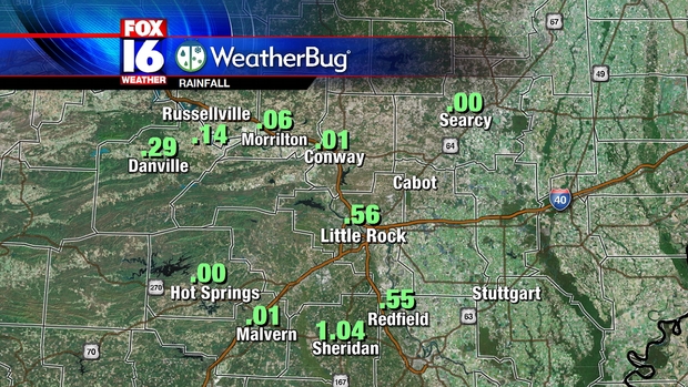
Some spots received some heavy rainfall associated with the storms, not everyone received significant rainfall. Monticello received over 2 inches of rain, while Little Rock National only recorded 0.06".


 Below is a summary of the storm reports as received by the National Weather Service in Little Rock

PRELIMINARY LOCAL STORM REPORT...SUMMARY
NATIONAL WEATHER SERVICE LITTLE ROCK AR
REPORTS FOR JUNE 11-12 2012

..TIME...   ...EVENT...      ...CITY LOCATION...     ...LAT.LON...
..DATE...   ....MAG....      ..COUNTY LOCATION..ST.. ...SOURCE....
            ..REMARKS..

<<<< JUNE 11TH >>>>

1145 AM     TSTM WND DMG     1 S OMAHA               36.45N 93.19W
06/11/2012                   BOONE              AR   LAW ENFORCEMENT

            POWER LINES ARE DOWN ALONG OLD HIGHWAY 65 SOUTH OF OMAHA.


1201 PM     TSTM WND DMG     8 NW LEAD HILL          36.50N 93.01W
06/11/2012                   BOONE              AR   LAW ENFORCEMENT

            LARGE TREE IS DOWN ON HIGHWAY 281 NORTH OF HIGHWAY 14 AND
            IS BLOCKING THE ROAD.

1202 PM     HAIL             RIDGEWAY                36.32N 93.20W
06/11/2012  E1.50 INCH       BOONE              AR   TRAINED SPOTTER

0128 PM     TSTM WND DMG     MARSHALL                35.91N 92.64W
06/11/2012                   SEARCY             AR   LAW ENFORCEMENT

            TREES ARE DOWN IN MARSHALL.

0203 PM     HAIL             BATESVILLE              35.77N 91.62W
06/11/2012  E0.88 INCH       INDEPENDENCE       AR   TRAINED SPOTTER

0210 PM     TSTM WND DMG     ALREAD                  35.63N 92.68W
06/11/2012                   VAN BUREN          AR   LAW ENFORCEMENT

            POWER LINES WERE REPORTED DOWN IN ALREAD

0228 PM     TSTM WND DMG     HEBER SPRINGS           35.50N 92.04W
06/11/2012                   CLEBURNE           AR   LAW ENFORCEMENT

            TREES REPORTED DOWNED IN THE HEBER SPRINGS AREA.

0250 PM     TSTM WND DMG     FLOYD                   35.18N 91.97W
06/11/2012                   WHITE              AR   PUBLIC

            A TREE WAS DOWNED ALONG HIGHWAY 31.

0308 PM     TSTM WND GST     1 SE SEARCY             35.23N 91.72W
06/11/2012  E60.00 MPH       WHITE              AR   FIRE DEPT/RESCUE

0310 PM     TSTM WND GST     2 NW BUTLERVILLE        34.99N 91.88W
06/11/2012  E60.00 MPH       LONOKE             AR   TRAINED SPOTTER

            WINDS EST AT 60 MPH WITH POWER OUTAGES IN BUTLERVILLE.

0319 PM     NON-TSTM WND DMG MAUMELLE                34.85N 92.41W
06/11/2012                   PULASKI            AR   TRAINED SPOTTER

            TREE LIMBS DOWN DUE TO OUTFLOW AHEAD OF STORMS. WIND EST
            40 MPH.

0323 PM     HAIL             LITTLE ROCK AIR FORCE B 34.92N 92.15W
06/11/2012  E0.50 INCH       PULASKI            AR   TRAINED SPOTTER

            WINDS WERE ESTIMATED AT 45 MPH.

0325 PM     TSTM WND DMG     SHERWOOD                34.83N 92.21W
06/11/2012                   PULASKI            AR   NWS EMPLOYEE

            A TREE WAS SNAPPED OFF OF BEAR PAW ROAD ALONG CHESTNUT
            DRIVE.

0327 PM     TSTM WND DMG     HICKORY PLAINS          34.98N 91.73W
06/11/2012                   PRAIRIE            AR   PUBLIC

            TREES WERE REPORTED DOWN IN HICKORY PLAINS.

0335 PM     TSTM WND DMG     AUSTIN                  35.00N 91.98W
06/11/2012                   LONOKE             AR   PUBLIC

            A LARGE OAK TREE WITH 24 INCH DIAMETER BASE BROKE OFF AT
            BASE.

0350 PM     TSTM WND DMG     DE VALLS BLUFF          34.79N 91.46W
06/11/2012                   PRAIRIE            AR   PUBLIC

            A LARGE LIMB FELL ON A HOUSE.

0350 PM     TSTM WND DMG     2 W DE VALLS BLUFF      34.79N 91.50W
06/11/2012                   PRAIRIE            AR   PUBLIC

            A CARPORT WAS BLOWN INTO A FIELD.

0355 PM     TSTM WND DMG     CLARENDON               34.70N 91.31W
06/11/2012                   MONROE             AR   LAW ENFORCEMENT

            TREE DOWN ON HWY 79.

0400 PM     HAIL             CONWAY                  35.09N 92.45W
06/11/2012  E0.88 INCH       FAULKNER           AR   PUBLIC

0403 PM     TSTM WND DMG     CONWAY                  35.09N 92.45W
06/11/2012                   FAULKNER           AR   AMATEUR RADIO

            SEVERAL TREE LIMBS REPORTED DOWNED.


0403 PM     TSTM WND DMG     CONWAY                  35.09N 92.45W
06/11/2012                   FAULKNER           AR   AMATEUR RADIO

            SEVERAL TREE LIMBS REPORTED DOWNED. LARGE 18 INCH
            DIAMETER LIMB WENT THROUGH A ROOF OF A HOUSE.

0408 PM     HAIL             CONWAY                  35.09N 92.45W
06/11/2012  E1.00 INCH       FAULKNER           AR   PUBLIC

0410 PM     TSTM WND DMG     2 NE CLARENDON          34.72N 91.28W
06/11/2012                   MONROE             AR   EMERGENCY MNGR

            TWO SHEDS WERE BLOWN DOWN...GRAIN BINS WERE DAMAGED...AND
            TREES WERE BLOWN DOWN.

0413 PM     TSTM WND DMG     ROE                     34.63N 91.39W
06/11/2012                   MONROE             AR   PUBLIC

            TREE FELL ON TRAILER.

0426 PM     TSTM WND DMG     STUTTGART               34.49N 91.55W
06/11/2012                   ARKANSAS           AR   LAW ENFORCEMENT

            POWER POLE DOWN ON CAR AND SEVERAL TREE LIMBS REPORTED
            DOWNED.

0445 PM     TSTM WND DMG     LODGE CORNER            34.30N 91.53W
06/11/2012                   ARKANSAS           AR   PUBLIC

            SHINGLES WERE BLOWN OFF THE ROOF OF A HOUSE.

0505 PM     TSTM WND DMG     TICHNOR                 34.14N 91.27W
06/11/2012                   ARKANSAS           AR   PUBLIC

            TREE FELL ON TRUCK.

0526 PM     TSTM WND DMG     3 WNW WATSON            33.91N 91.31W
06/11/2012                   DESHA              AR   LAW ENFORCEMENT

            TREES WERE BLOWN DOWN ON ARKANSAS HIGHWAY 1.

0625 PM     TSTM WND DMG     7 SE SELMA              33.63N 91.48W
06/11/2012                   DREW               AR   DEPT OF HIGHWAYS

            TREES REPORTED DOWN ACROSS HWY 278.

0644 PM     TSTM WND DMG     6 NNE MONTICELLO        33.71N 91.75W
06/11/2012                   DREW               AR   CO-OP OBSERVER

            TREE LIMBS REPORTED DOWNED.

0710 PM     TSTM WND DMG     6 W MCGEHEE             33.63N 91.50W
06/11/2012                   DREW               AR   PUBLIC

            TREES WERE BLOWN DOWN.

0715 PM     TSTM WND DMG     3 NNW JEROME            33.44N 91.49W
06/11/2012                   DREW               AR   PUBLIC

            A TREE WAS BLOWN DOWN ACROSS SPILWAY ROAD AT LAKE
            WALLACE.

1115 PM     TSTM WND DMG     7 NW ALEXANDER          34.70N 92.53W
06/11/2012                   PULASKI            AR   BROADCAST MEDIA

            TREES WERE DOWN BLOCKING COLONEL GLENN ROAD AT THE
            SALINE/PULASKI COUNTY LINE.

1155 PM     TSTM WND DMG     4 WNW BENTON            34.59N 92.64W
06/11/2012                   SALINE             AR   LAW ENFORCEMENT

            A TREE WAS BLOWN DOWN NEAR HIGHWAY 5 AND KENTUCKY ROAD.


<<<< JUNE 12TH >>>>

1205 AM     TSTM WND DMG     1 ENE BAUXITE           34.56N 92.51W
06/12/2012                   SALINE             AR   LAW ENFORCEMENT

            LIMBS WERE BLOWN DOWN AND ONTO WEST SARDIS ROAD.

1225 AM     TSTM WND DMG     STEPHENS                33.42N 93.07W
06/12/2012                   OUACHITA           AR   LAW ENFORCEMENT

            TREES WERE BLOWN DOWN.

0100 AM     TSTM WND DMG     8 WSW HAMPTON           33.49N 92.59W
06/12/2012                   CALHOUN            AR   CO-OP OBSERVER

            LIMBS WERE BLOWN DOWN.

0600 AM     FLASH FLOOD      GAP CREEK RECREATION AR 34.55N 93.44W
06/12/2012                   MONTGOMERY         AR   LAW ENFORCEMENT

            LOW WATER CROSSINGS WERE FLOODED IN BOTH THE GAP CREEK
            AND HICKORY NUT MOUNTAIN RECREATION AREAS.

Monday, June 11, 2012

Storms Monday June 11

A Severe Thunderstorm Watch has been issued for much of Northern Arkansas through late this afternoon. A line of thunderstorms is moving Southward through Missouri which will impact Northern Counties by about Noon. In addition, individual storms will develop ahead of this line, with a significant threat if large hail and some isolated wind gusts also possible.


The threat of storms for Central Arkansas will increase later this afternoon into the evening hours as storms begin to shift South. The Storm Prediction Center indicates a SLIGHT risk for severe storms for today with hail and wind the primary threats.


The tornado threat is overall low, however, a brief tornado cannot be completely ruled out with some of the stronger individual storms during the afternoon and early evening hours.

Sunday, June 10, 2012

Strong Storms on the Horizon


Well, the latest weather models are out and they all agree that Mother Nature could bring us a good dousing sometime early next week.  Before you stop watering the lawn and washing the car, you might want to keep this thought in mind - besides the rain chances there will be a shot at some strong thunderstorms in Central Arkansas.

                                      (Weather model shows strong thunderstorms Monday at 2 P.M.)

As a weak cold front struggles to move southward Monday afternoon, there will be an unstable air mass out ahead of it in Arkansas.  If there is enough forcing present and daytime heating, we could see large hail and gusty winds develop.  When it comes to a tornado threat it appears it is slim to none at this point with the lack of strong upper level winds.


The Storm Prediction Center has taken note of this setup and issued a slight risk of severe weather for Arkansas.  If you're not familiar with slight risk outlook, it just means that well-organized severe thunderstorms are expected but in relatively small numbers/coverage.

No matter what SPC has to say about our weather, we'll continue to monitor the severe threats late Monday.  Be sure to keep it tuned to FOX 16 News for the latest on this developing story.


Thursday, June 7, 2012

Drought Conditions worsening in Arkansas

The recent dry weather is beginning to take its toll on Arkansas with drought conditions spreading throughout the State. As of May 25th, most of Arkansas was considered "dry" with Northeast Arkansas in moderate drought according to The U.S. Drought Monitor, which tracks drought conditions across the United States.


The latest drought monitor analysis released the week of June 7th now shows most of Arkansas in the moderate drought category


Rain chances will go up for the early part of next week, however rain coverage is likely to be quite isolated. The seasonal drought outlook released by NOAA  (National Oceanic and Atmospheric Administration) indicates drought conditions across most of Arkansas will either persist or get worse through the Summer season.


Tuesday, June 5, 2012

Landspout Tornado in Lonoke County

A brief landspout type tornado touched down in Lonoke County Monday afternoon according to The National Weather Service in Little Rock. This was not a classic tornado produced by a rotating thunderstorm, but rather a landspout which is basically a waterspout over land. A landspout sometimes forms underneath a rapidly growing towering cumulus cloud away from thunderstorms on very warm and humid days. They typically form during the Summer months and are very weak and short lived compared to ordinary tornadoes. Below is a picture of the funnel taken by a storm Chaser in Lonoke County Monday afternoon.


 The storm chaser noted to the weather service that there was no thunder at the time. According to The Weather Service, there was no storm showing any signs of rotation in the area, which is why there was no warning issued.  Below is a map showing the estimated location of the landspout tornado.


According to John Robinson of The National Weather Service in Little Rock, the landspout touched down roughly 7 miles South-Southwest of Carlisle in Lonoke County near Arkansas Highway 13. There was no damage or even much in the way of any physical evidence of a tornado touchdown associated with the landspout. Given the lack of any discernible damage, the landspout is classified as an EF0 tornado with no real path length or width. An EF0 is the weakest classification of a torando with winds less than 85 MPH. The Weather Service used pictures to determine that the funnel briefly touched down. The landspout still counts as a tornado though, which brings the Arkansas 2012 tornado count to 11.


Viewing the Transit of Venus

Astronomy enthusiasts will get a glimpse of a very rare sight this evening.  The planet Venus will run its course and position itself in front of our Sun to where we are suppose to see it on Earth. Known as the "transit of Venus", this twice in a generation viewing happens every 105.5 and 121.5 years.  We saw our last transit of Venus in 2004, so this means today's sighting will be the last one until December 2117.


The question is will we see it in Arkansas?


If the transit of Venus were to occur this Tuesday afternoon we might have a hard time looking for it with all of the cumulus clouds around.  However, looking ahead in the future the cloud cover will be less and the sky should be clear enough to see the transit this evening.

According to NASA, the transit of Venus will begin at 5:09 P.M. and will go on until the sun sets over the horizon at 8:19 P.M.

If you plan on trying to take a snapshot of it with your camera just be aware that you have to careful with your eyes - they could be damaged by looking at the sun for a length of time.  The safest way to view the transit is to construct a so-called pinhole camera. 


Monday, June 4, 2012

Some storms, much needed rainfall

Update:

The National Weather Service in Little Rock has reported that landspout tornado may have briefly touched down Monday afternoon in Lonoke County between Humnoke and Carlisle along Highway 13. The picture below shows the funnel, but does not show it touching the ground.


A landspout does not originate from a super-cell thunderstorm as does a regular tornado. These usually form underneath towering cumulus clouds under the right conditions away from thunderstorms. It is actually caused by the same process that causes a waterspout, but forms over land. Landspouts are usually much weaker than regular tornadoes and do not last very long. No damage was reported. The landspout does count as a tornado, and brings the total tornado count for Arkansas for the year up to 11.

A round of storms Monday afternoon brought much needed rainfall to Central Arkansas, with a few reports of severe weather. Storms were not as strong as Sunday, but some spots were hit by hail and some strong wind gusts. Below is a map of storm reports Monday followed by the descriptions of the reports.


PRELIMINARY LOCAL STORM REPORT...SUMMARY
NATIONAL WEATHER SERVICE LITTLE ROCK AR
708 PM CDT MON JUN 04 2012

..TIME...   ...EVENT...      ...CITY LOCATION...     ...LAT.LON...
..DATE...   ....MAG....      ..COUNTY LOCATION..ST.. ...SOURCE....
            ..REMARKS..

0125 PM     TSTM WND DMG     2 E WILLIAMS JUNCTION   34.88N 92.74W
06/04/2012                   PULASKI            AR   PUBLIC         

            THUNDERSTORM WINDS BROKE OFF THE TOPS OF SEVERAL OAK
            TREES AT THE PERRY/PULASKI COUNTY LINE.

0340 PM     HEAVY RAIN       1 ENE NORTH LITTLE ROCK 34.79N 92.24W
06/04/2012  M1.50 INCH       PULASKI            AR   AMATEUR RADIO  

            AMATEUR RADIO REPORTED 1.50 INCHES OF RAIN IN 30 MINUTES.


0342 PM     HAIL             3 N LEOLA               34.21N 92.59W
06/04/2012  E1.00 INCH       GRANT              AR   PUBLIC         

            MEMBER OF PUBLIC CALLED AND REPORTED HAIL APPROXIMATELY
            THE SIZE OF QUARTERS.

0344 PM     HAIL             POYEN                   34.32N 92.64W
06/04/2012  E1.00 INCH       GRANT              AR   PUBLIC         

0355 PM     HEAVY RAIN       2 N NORTH LITTLE ROCK   34.82N 92.26W
06/04/2012  M1.15 INCH       PULASKI            AR   OFFICIAL NWS OBS

            BETWEEN 300 PM AND 355 PM CDT 1.15 INCHES OF RAIN FELL AT
            THE NWS OFFICE IN NORTH LITTLE ROCK.

0426 PM     TSTM WND DMG     1 N GRAPEVINE           34.16N 92.32W
06/04/2012                   GRANT              AR   LAW ENFORCEMENT

            TREES ARE DOWN ALONG COUNTY ROAD 16 NORTH OF GRAPEVINE.

0508 PM     TSTM WND DMG     RISON                   33.95N 92.19W
06/04/2012                   CLEVELAND          AR   LAW ENFORCEMENT

            MANY POWER LINES ARE DOWN ACROSS RISON LEAVING MANY
            PEOPLE WITHOUT POWER.

0529 PM     HAIL             2 W IVAN                33.90N 92.47W
06/04/2012  E1.00 INCH       DALLAS             AR   TRAINED SPOTTER

The storms did bring much needed rainfall to many parts of the State over the last couple of days. Below is a map of rainfall amounts around the State since Sunday morning.


North Little Rock broke its daily rainfall record for the day with 1.36". 1.15" of that rainfall fell in a single hour. Our FOX16 Weatherbug stations across Central Arkansas also reported some decent rainfall totals in a few spots Monday.


The wetter pattern will not last as drier air moves in for the middle of the week behind a weak front. Rain chances will drop to around zero for the rest of the week with afternoon showers not returning until early next week.
Numerous thunderstorms brought hail and some strong wind gusts to the Northern half of Arkansas Sunday. No major damage was reported, but some large tree limbs were brought down and hail was larger than Golf Ball size in a couple of locations. Below is a map of the damage reports from Sunday.


 One of the hardest hit places Sunday was the town of Shirley in Van Buren County, where strong winds brought down numerous trees and caused some damage. The National Weather Service determined straight line winds of 75 MPH were responsible. Below is a complete list of severe weather reports from Sunday June 3rd.

PRELIMINARY LOCAL STORM REPORT...SUMMARY
NATIONAL WEATHER SERVICE LITTLE ROCK AR
719 PM CDT MON JUN 04 2012

..TIME...   ...EVENT...      ...CITY LOCATION...     ...LAT.LON...
..DATE...   ....MAG....      ..COUNTY LOCATION..ST.. ...SOURCE....
            ..REMARKS..

0434 PM     HAIL             5 NNE COMPTON           36.15N 93.28W
06/03/2012  E1.00 INCH       BOONE              AR   PUBLIC         

0522 PM     TSTM WND GST     VENDOR                  35.95N 93.08W
06/03/2012  M59.00 MPH       NEWTON             AR   TRAINED SPOTTER

            A 59 MPH GUST WAS MEASURED AT VENDOR.

0522 PM     TSTM WND DMG     PIERCETOWN              35.97N 93.07W
06/03/2012                   NEWTON             AR   TRAINED SPOTTER

            TREES REPORTED DOWN.

0526 PM     HAIL             OLYPHANT                35.52N 91.38W
06/03/2012  E1.75 INCH       JACKSON            AR   LAW ENFORCEMENT

0616 PM     HAIL             OIL TROUGH              35.63N 91.46W
06/03/2012  E0.75 INCH       INDEPENDENCE       AR   TRAINED SPOTTER

0620 PM     HAIL             3 ENE BOTKINBURG        35.72N 92.47W
06/03/2012  M1.75 INCH       VAN BUREN          AR   TRAINED SPOTTER

            CORRECTION TO THE REPORT OF GOLF BALL SIZE HAIL 3ENE OF
            DENNARD. SPOTTER WAS 3ENE OF BOTKINBURG.

0620 PM     TSTM WND DMG     CLINTON                 35.58N 92.45W
06/03/2012                   VAN BUREN          AR   TRAINED SPOTTER

            TREES WERE DOWNED IN CLINTON.

0620 PM     HAIL             DENNARD                 35.75N 92.52W
06/03/2012  E1.50 INCH       VAN BUREN          AR   TRAINED SPOTTER

0627 PM     TSTM WND DMG     SHIRLEY                 35.64N 92.31W
06/03/2012                   VAN BUREN          AR   LAW ENFORCEMENT

            SEVERAL TREES AND POWERLINES DOWNED WITH REPORTS OF ROOF
            DAMAGE.

0627 PM     TSTM WND DMG     SHIRLEY                 35.64N 92.31W
06/03/2012                   VAN BUREN          AR   NWS STORM SURVEY

            THOUSANDS OF TREES WERE SNAPPED OFF, UPROOTED, AND/OR
            BLOWN DOWN WITHIN A SEVEN MILE RADIUS OF SHIRLEY. SEVERAL
            TREES FELL ON HOUSES. SHINGLES WERE TAKEN OFF ROOFS AND
            METAL OFF OF BARNS. OUTBUILDINGS WERE DAMAGED AND A
            VEHICLE WAS TRAPPED BY FALLEN POWERLINES. NO INJURIES
            WERE REPORTED. WINDS WERE ESTIMATED AT 75 MPH. A SPECIAL
            THANKS GOES OUT TO COUNTY JUDGE ROGER HOOPER FOR HIS
            ASSISTANCE WITH THIS NWS STORM SURVEY.

0633 PM     HAIL             OARK                    35.68N 93.58W
06/03/2012  E1.00 INCH       JOHNSON            AR   LAW ENFORCEMENT

0635 PM     TSTM WND DMG     6 N CLINTON             35.67N 92.45W
06/03/2012                   VAN BUREN          AR   AWOS           

            A WIND GUST OF 53 MPH WAS MEASURED AT THE CLINTON
            AIRPORT.

0644 PM     TSTM WND DMG     3 SE HARMONY            35.52N 93.53W
06/03/2012                   JOHNSON            AR   LAW ENFORCEMENT

            WINDS EST. AT 60 MPH. TREES AND STRUCTURE DAMAGE
            REPORTED. ALSO PEA SIZE HAIL.

0645 PM     TSTM WND DMG     2 E FAIRFIELD BAY       35.61N 92.23W
06/03/2012                   CLEBURNE           AR   PUBLIC         

            TREES WERE DOWN IN THE GREERS FERRY LAKE AREA. A TREE
            LIMB FELL ON TO A POWER LINE. TREES WERE BLOWN DOWN IN
            THE DEVILS FORK RECREATION AREA.

0655 PM     HAIL             HICKORY FLAT            35.48N 91.75W
06/03/2012  E2.50 INCH       WHITE              AR   PUBLIC         

0656 PM     TSTM WND DMG     COTTER                  36.28N 92.52W
06/03/2012                   BAXTER             AR   BROADCAST MEDIA

            TREES WERE BLOWN DOWN.

0715 PM     TSTM WND GST     3 S BATESVILLE          35.72N 91.62W
06/03/2012  M48.00 MPH       INDEPENDENCE       AR   AWOS           

0720 PM     TSTM WND DMG     BATESVILLE              35.77N 91.62W
06/03/2012                   INDEPENDENCE       AR   LAW ENFORCEMENT

            NUMEROUS TREES AND POWER LINES WERE BLOWN DOWN...SOME
            TREES FELL ON HOUSES. ALSO THERE WERE SOME FIRES STARTED
            BY LIGHTNING.

0724 PM     HAIL             LONDON                  35.33N 93.25W
06/03/2012  E0.88 INCH       POPE               AR   TRAINED SPOTTER

0724 PM     TSTM WND DMG     LONDON                  35.33N 93.25W
06/03/2012                   POPE               AR   TRAINED SPOTTER

            TREES WERE BLOWN DOWN.

0737 PM     HAIL             RUSSELLVILLE            35.27N 93.14W
06/03/2012  E1.00 INCH       POPE               AR   TRAINED SPOTTER

0747 PM     TSTM WND GST     3 SE OIL TROUGH         35.60N 91.42W
06/03/2012  M61.00 MPH       INDEPENDENCE       AR   TRAINED SPOTTER

0754 PM     TSTM WND DMG     POTTSVILLE              35.24N 93.06W
06/03/2012                   POPE               AR   TRAINED SPOTTER

            MULTIPLE TREE LIMBS ARE DOWN WITH SOME DAMAGE TO A ROOF.

0840 PM     HAIL             OPPELO                  35.10N 92.78W
06/03/2012  E0.88 INCH       CONWAY             AR   TRAINED SPOTTER

0855 PM     HAIL             BIGELOW                 35.00N 92.63W
06/03/2012  E1.00 INCH       PERRY              AR   PUBLIC         

0910 PM     TSTM WND DMG     2 W MAYFLOWER           34.97N 92.46W
06/03/2012                   FAULKNER           AR   TRAINED SPOTTER

            TREE DOWN ON WINTER CREEK ROAD NEAR HWY 89 WEST OF
            MAYFLOWER

1235 AM     HAIL             MOUNTAIN HOME           36.34N 92.38W
06/04/2012  E0.88 INCH       BAXTER             AR   PUBLIC         

1240 AM     HAIL             MOUNTAIN HOME           36.34N 92.38W
06/04/2012  E1.25 INCH       BAXTER             AR   LAW ENFORCEMENT

1243 AM     HAIL             MOUNTAIN HOME           36.34N 92.38W
06/04/2012  E1.75 INCH       BAXTER             AR   PUBLIC         

A couple of tornado reports in Northeast Arkansas were relayed to NWS Memphis, but no tornadoes have been confirmed as of Monday Evening.