The National Weather Service in Little Rock has reported that landspout tornado may have briefly touched down Monday afternoon in Lonoke County between Humnoke and Carlisle along Highway 13. The picture below shows the funnel, but does not show it touching the ground.

A landspout does not originate from a super-cell thunderstorm as does a regular tornado. These usually form underneath towering cumulus clouds under the right conditions away from thunderstorms. It is actually caused by the same process that causes a waterspout, but forms over land. Landspouts are usually much weaker than regular tornadoes and do not last very long. No damage was reported. The landspout does count as a tornado, and brings the total tornado count for Arkansas for the year up to 11.
A round of storms Monday afternoon brought much needed rainfall to Central Arkansas, with a few reports of severe weather. Storms were not as strong as Sunday, but some spots were hit by hail and some strong wind gusts. Below is a map of storm reports Monday followed by the descriptions of the reports.

PRELIMINARY LOCAL STORM REPORT...SUMMARY
NATIONAL WEATHER SERVICE LITTLE ROCK AR
708 PM CDT MON JUN 04 2012
..TIME... ...EVENT... ...CITY LOCATION... ...LAT.LON...
..DATE... ....MAG.... ..COUNTY LOCATION..ST.. ...SOURCE....
..REMARKS..
0125 PM TSTM WND DMG 2 E WILLIAMS JUNCTION 34.88N 92.74W
06/04/2012 PULASKI AR PUBLIC
THUNDERSTORM WINDS BROKE OFF THE TOPS OF SEVERAL OAK
TREES AT THE PERRY/PULASKI COUNTY LINE.
0340 PM HEAVY RAIN 1 ENE NORTH LITTLE ROCK 34.79N 92.24W
06/04/2012 M1.50 INCH PULASKI AR AMATEUR RADIO
AMATEUR RADIO REPORTED 1.50 INCHES OF RAIN IN 30 MINUTES.
0342 PM HAIL 3 N LEOLA 34.21N 92.59W
06/04/2012 E1.00 INCH GRANT AR PUBLIC
MEMBER OF PUBLIC CALLED AND REPORTED HAIL APPROXIMATELY
THE SIZE OF QUARTERS.
0344 PM HAIL POYEN 34.32N 92.64W
06/04/2012 E1.00 INCH GRANT AR PUBLIC
0355 PM HEAVY RAIN 2 N NORTH LITTLE ROCK 34.82N 92.26W
06/04/2012 M1.15 INCH PULASKI AR OFFICIAL NWS OBS
BETWEEN 300 PM AND 355 PM CDT 1.15 INCHES OF RAIN FELL AT
THE NWS OFFICE IN NORTH LITTLE ROCK.
0426 PM TSTM WND DMG 1 N GRAPEVINE 34.16N 92.32W
06/04/2012 GRANT AR LAW ENFORCEMENT
TREES ARE DOWN ALONG COUNTY ROAD 16 NORTH OF GRAPEVINE.
0508 PM TSTM WND DMG RISON 33.95N 92.19W
06/04/2012 CLEVELAND AR LAW ENFORCEMENT
MANY POWER LINES ARE DOWN ACROSS RISON LEAVING MANY
PEOPLE WITHOUT POWER.
0529 PM HAIL 2 W IVAN 33.90N 92.47W
06/04/2012 E1.00 INCH DALLAS AR TRAINED SPOTTER
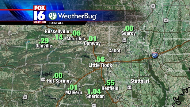
The storms did bring much needed rainfall to many parts of the State over the last couple of days. Below is a map of rainfall amounts around the State since Sunday morning.

North Little Rock broke its daily rainfall record for the day with 1.36". 1.15" of that rainfall fell in a single hour. Our FOX16 Weatherbug stations across Central Arkansas also reported some decent rainfall totals in a few spots Monday.
The wetter pattern will not last as drier air moves in for the middle of the week behind a weak front. Rain chances will drop to around zero for the rest of the week with afternoon showers not returning until early next week.
No comments:
Post a Comment