Wednesday, February 29, 2012

Friday's Severe Weather Potential

Even though Arkansas escaped the tornadoes and damaging winds late Tuesday night, we can't let our guard down when it comes to severe weather.

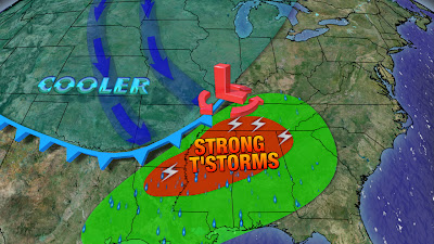
Later this week on Friday, another strong area of low pressure is expected to develop right in our backyard in Northwest Arkansas and track due northeast through the upper Mid-West.


Out ahead of the low pressure system, there will be warm gulf air that will surge back into Central and Eastern Arkansas.  At the very same time, winds aloft will be rotating...Inevitably all of these ingredients will help set the stage for nasty thunderstorms to develop into parts of Arkansas and the Mississippi Valley.

At the moment, it's too soon to tell how every little detail will play out on Friday, but we do know that this next storm system is different from the last one in many ways.  This time the low pressure will very close to us unlike Tuesday's night storm.  In addition to the position, the winds thousands of feet above us will show greater spin then last time.  What this means for you is that parts Arkansas may not be so lucky in escaping tornadoes and damaging winds.

                        (SPC SREF model showing enhanced tornado risk in Eastern AR and Memphis)

Preliminary data shows the main tornado threat lies in Eastern Arkansas and around the Memphis region.  We happen to agree with this assessment at this time.  Cities that need to play close attention on Friday's weather include Little Rock, Pine Bluff, Searcy, Stuttgart and Jonesboro.

Besides the threat area, there is still some questions in regard to the timing of this whole event.  Majority of the weather models want to have the thunderstorms developing around Central and Eastern Arkansas as soon as 12 P.M. Friday and lasting through the region for a couple hours.  Other weather models wait longer into the mid afternoon. We'll hold off on pinpointing every hour by hour for now but it looks like we need to be ready around the early afternoon period.

Be sure to keep checking with FOX 16 so you can plan ahead accordingly for this next upcoming storm system.

Monday, February 27, 2012

A Week Filled with Strong Storms

This last week of February is shaping up to be quite interesting in the Natural State.

At this hour we're watching a storm system develop in the Pacific Northwest and progressing to the southeast.  As this disturbance wraps up and becomes stronger, a rather intense surface low will emerge in the Central Plains.


Underneath the low pressure will be a cold front and a rather good supply of gulf moisture to work with it. Out ahead of the cold front there will be spinning winds aloft. Inevitably this means severe weather is possible for the Mississippi Valley and Arkansas.

Judging by the computer models, the worst threats from these potential storms will be short-lived tornadoes, damaging winds and small hail.


                         (The Significant Tornado Parameter index shows the best chance at tornadoes in Western Arkansas.)


As more data pours into the FOX 16 weather center, it is more apparent that Western Arkansas has the best opportunity for seeing the worst out of this storm system.  It is in this region where there will be better lift and rotation in the atmosphere.  The window of opportunity for these strong storms to develop will be between 6 P.M. Tuesday through midnight.  Cities that need to be pay close attention to the weather are Mena, Fort Smith, Fayetteville, Arkadelphia and Harrison.


Before everybody battens down the hatches, there is an inhibiting factor that may play a huge role in preventing these severe thunderstorms from developing.  One very important ingredient that seems absent from this setup is instability (the ability for storms to sustain lift).  Almost every weather model paints a cloudy, wet scenery in Arkansas before the storm system gets going late Tuesday evening.  This kind of environment is definitely not ideal for thunderstorm development.  In reality, you need to warm up or cook the atmosphere so to speak before severe weather can form and we're not seeing that from the models.

In essence, if we see clouds and showers most of Tuesday then our severe chances will be low.  On the other hand, if we're able to hold off on the showers and see the clouds reveal a little sunshine before Tuesday evening rolls around we may be in for a long night.

If that wasn't enough, we're not done with the threat of severe weather this week.  On Friday, Mother Nature looks to send another potent system our way.   

Keep checking back with FOX 16 over the next couple days for more details about the severe weather potential for this week.

Tuesday, February 21, 2012

Slim Shot at Severe Weather

While our weather heats up to the 70s this week, our eyes are focus on the disturbance coming from the Rockies.

Thursday evening a deep trough will swing through the Mississippi Valley creating a surface low in the Mid-West.  Underneath this low will be a fairly strong cold front. Once the cold front slips down to our neighborhood there is a slim chance that severe weather will break out near the southeast corner of the state.


Luckily we'll have an inversion of warm air aloft that will make it hard for thunderstorms to form in Central Arkansas.  Southeast Arkansas may not be so lucky and will need to be evaluated for Thursday evening. 

                                             (NAM model showing no storms early Thursday evening)


As of right now all of the computer models suggest that the storms will not develop until they are well south of Arkansas.  Our computer model at FOX 16 is on the same page as every other weather model out there.  Of course, these are just computer models and they typically struggle with surface based convection (i.e. storms development) which is the type of convection we would be looking at on this day.

                                  (FOX 16 weather model shows low tornado potential for areas south of AR.)

If these storms do manage to develop, we are looking at the possibility of tornadoes, large hail and gusty winds.

We'll stay on top of this developing story and let you know the latest on FOX 16.


Monday, February 20, 2012

Warm Surge

After a chilly start to this February, we'll finally get a chance to enjoy some warmth.


Before we can tap into the heat, we will go through a quick stretch of wet weather.  Tonight a weak cold front, and I say cold front lightly here, will rush into Arkansas during the midnight hour.  As the front works across our region it will carry in a line of showers and storms with it.  Overall, this line of showers will not be a problem for us.


After tonight, our surface winds will constantly come in from the west/southwest.  For us that means a warm stretch of weather.  Temperatures on both Wednesday and Thursday look to rise all the way up to the 70s.  If the forecast pans out we'll be pretty close to some record highs around here.  Of course this warm pattern won't last too long. Mother Nature will put an end to this warm surge by the end of the work week with temperatures plummeting back to the 50s.

                              (NAM model showing storms developing ahead of a cold front Thursday evening)

There are subtle hints that as this cooler air comes into Arkansas, we could endure some severe weather near the southeast corner of the state.  Of course it's too soon to speculate with great detail right now but it will be something to watch for in the next couple days.  Until then soak up the warmth and sunshine.

Friday, February 17, 2012

Rainy Saturday...Few Flakes North?

Earlier this week, I mentioned the chance for snow on Saturday night...If you recall I said it was basically slim to none for Northern/Northeast Arkansas.

                                     (Latest FOX 16 weather model showing no snow for Central Arkansas)

Several days have come and gone and nothing has changed.  An unsettled surface low will still take center stage near the Gulf Coast on Saturday.  Due to the lift and abundant moisture supply, we'll see numerous bands of showers and thunderstorms wrap around the low.  Eventually this rain will spread into Arkansas. When it comes to snow, we expect a dusting, at best, to fall in extreme Northern Arkansas.  Nothing will stick to ground since temperatures will be above freezing.

If you're wondering about the timing of the rain well here is our exclusive FOX 16 weather model giving you a glimpse at what to expect.


EARLY MORNING:  We'll begin Saturday with a cloudy sky and chilly temperatures in the 40s.  Most of the heavy rain is still hours away from Central Arkansas.


NOON: Rain becomes widespread across parts of Central and Southern Arkansas.


LATE EVENING: Rain still scattered across the state with a little mix of sleet in Northwest Arkansas.  Temperatures will be above freezing so it won't stick to the roads.

So that is a break down of your Saturday.  As for Sunday, we'll dry out and watch the clouds clear out with temperatures back to the low 50s.

Thursday, February 16, 2012

Chance of More Snow?

The buzz around the weather department is snow...again...but before you go out to buy milk and bread you might want to read the full details about this upcoming weather pattern.

This weekend a surface low will hug the gulf coast providing a good blanket of rain and storms around it.  Arkansas will be on the northern fringe of this system and will receive a good soaking rain south of Little Rock.  As cool air is brought in from the back side of the system late Saturday night, there are discussions saying there is an opportunity for snow in Central Arkansas.

                                    (FOX 16 weather model shows a dusting of snow is possible in E/NE AR)
              
Well, I hate to spoil the fun here but there is very, very low chance that we'll see a snowflake in Little Rock and most of Central Arkansas. 


                                           (GFS weather model showing no snow for the entire state.)
                         
The main issue with this upcoming disturbance is the lack of arctic air near the surface of the atmosphere. As we look at the data, we keep noticing that the air coming around the back side of the low is not that cold.  In fact, most model runs do not show accumulating snow whatsoever because the air is too warm to sustain it (check out the image above).

Let's say for argument's sake, that the air is briefly cold enough to sustain snow.  Then the most likely place for accumulation will be east and northeast of Little Rock - not in the heart of the state.  Last but not least, if the snow does happen to fall late Saturday night, the snow will not stick to the roads since temperatures are expected to be several degrees above freezing.

All in all, this upcoming storm system will NOT be a problem for folks.  We'll see rain in many spots and a small chance of it turning to snow near Memphis.

Tuesday, February 14, 2012

Wednesday Showers & Storms

A storm system will approach from the West Wednesday bringing showers and some thunderstorms to the area, especially during the afternoon and early evening hours.


A warm front will push in from the South during the early afternoon with showers and isolated thunderstorms. This front will stall out across Central Arkansas with warmer temperatures across Southern portions of the State and cooler temperatures North. Temperatures across Southern Arkansas will warm well into the 60s, with 50s just North of the front. Below are computer projected temperatures for 5 PM Wednesday.


A cold front will approach during the evening with showers and few storms. Severe weather is unlikely, although a couple of stronger storms may be briefly capable of producing small hail. As of early Wednesday morning, the Storm Prediction Center does not include any part of Arkansas in a risk area for severe weather


The main threat from stronger storms will be hail, but an isolated strong wind gusts may also be possible. The tornado threat for Arkansas is minimal with this system. Most showers and remaining storms will push out of Central Arkansas by 9 PM

Sunday, February 12, 2012

Winter "Storm" Roundup

The Winter weather underperformed Monday, with most areas across Central Arkansas receiving less than an inch of snow. The snow quickly moved moved into Central Arkansas during the mid-morning hours as expected. Below is the radar image from 9 AM Monday


The darker blue indicates the heavier snow, which quickly accumulated on grassy surfaces.  Snow had already transitioned to a mix of sleet and freezing rain across Southwest and South Central Arkansas as indicated by the pink areas. Warm air just above the ground quickly advanced Northward, causing the snow to transition to sleet and freezing rain. By 11AM, snow had essentially come to an end across Central Arkansas.


The transition to sleet put an end to additional snow accumulations, with most spots ending up with around half an inch of snow and sleet. Had the transition occurred just an or so hour later, those accumulations would have very well been in the 1 to 2 inch range as originally predicted! Parts of Northern Arkansas had more accumulation where the duration of snowfall was longer. These are some of the snow totals from Monday.


This Winter may seem like a disappointment to snow lovers, but the snow total for this season is actually quite close to normal. Compared to last Winter though, this season isn't anywhere close when comes to Wintry weather.


Monday's Big Mess

A significant Winter storm is on the way for Monday as a disturbance crosses the State with cold air in place. Here is the time table for tomorrow's Storm:

7 AM: Light snow begins across West Central Arkansas, just reaching Russellville and Hot Springs. Cloudy with a few spits of sleet possible further East including the Little Rock area. No significant travel problems at this time.  This is our computer model projection for 7 AM Monday:


9 AM: Snow begins around the Little Rock Metro area as well as areas such as Conway, Sheridan and Heber Springs. Temperatures will be below freezing at the onset, so travel conditions will quickly become hazardous. Snow will transition to sleet and freezing rain roughly South of a line from Hot Springs to Sheridan to Pine Bluff.


1 PM: Mixed precipitation will reach Eastern Arkansas, with mostly rain Southeast Arkansas, and a mix of snow and sleet Northeast mainly North of I-40. As warmer air moves in just above the surface, snow will transition to a mixture of freezing rain, sleet and rain South of a line from Russellville to Conway to Beebe. A mix of of snow and ice pellets can be expected North of this line for much of North Central Arkansas. Travel will remain hazardous into the early afternoon except for Southern Arkansas, where temperatures will be well above freezing


5 PM: Temperatures will begin to warm above freezing across most of Central Arkansas, turning roads slushy and travel conditions begin to improve.

7 PM: Most remaining precipitation in the form of rain with temperatures a couple of degrees above freezing. A few spots of freezing rain may persist North. Travel conditions will continue to improve, but will remain dangerous in some spots.


Below are our forecast snowfall totals. This may change depend on the timing of the transition from snow to mixed precipitation. The sooner the transition occurs, the less snow will accumulate.


Thursday, February 9, 2012

Revenge of Winter

A blast of cold Arctic air will infiltrate Arkansas this weekend with some of the coldest temperatures of the season for Central Arkansas. Highs over the weekend will struggle to get out of the 30s. Sunday morning will be the coldest with low temperatures dropping into the mid 10s to lower 20s across Central Arkansas as Arctic High pressure builds into the State.


Portions of Northern Arkansas may get as cold as about 10 degrees. Below are computer model forecast low temperatures for Sunday morning.


The weekend will be cold and dry, however, an upper air disturbance will begin to approach Sunday night. This will will bring back clouds and moisture by early Monday morning. With the cold air still well entrenched Monday morning, precipitation across Central Arkansas will begin as a mixture of sleet, freezing rain and snow. Northern Arkansas is likely to receive mostly snow.


There is still considerable uncertainty as to the exact timing of the precipitation moving in, as well as in the position of the rain/snow line. It is too soon to estimate snow or ice accumulation amounts, but this system will likely be the most significant storm of the season for many parts of the State. It is becoming more probable that this system will have a major impact on the morning commute for Monday with possible delays and school closings

Friday Cold Front

A disturbance moving across the State ahead of an approaching cold front will bring light rain to the area on Friday. Temperatures will be just cold enough across parts of Northern Arkansas to support some mix in with snow for a short time. Some minor accumulations are possible for the higher elevations, mainly above about 600 feet and North of a line from around Clinton to Heber Springs to Batesville. The map below shows where snow may mix with the rain


Showers will come to an end by early afternoon as the disturbance pushes East. An Arctic cold front will sweep through during the evening ushering in a blast of even colder air for the weekend. High temperatures on Friday will range from the mid to upper 40s for Central Arkansas to the upper 30s North. Skies will clear out Friday night behind the cold front with lows dropping into the mid to upper 20s.

Tuesday, February 7, 2012

Wintry Weather Possible?


Mother Nature sure seems more in tuned with the winter season these days. Obviously we're no longer going through those warm stretches of 60 or 70 degree weather - that's for sure.  In the future it's going to stay chilly.  You could almost our weather will be downright cold on some days.

                                      (Arctic oscillation depicting a cold outlook for February)

To be honest, we saw this pattern shift coming a mile away.  The long term models were hinting at a colder stretch of weather and the arctic oscillation was heading into a negative phase...those are usually clear cut signs that colder air is coming to the country.

Now that we know that cooler days are ahead the bigger question becomes how cold it will get around here.  The reason this is key is because several weather models are showing a couple rounds of precipitation rolling through the state.  Obviously if temperatures are around 32 degrees near the surface, we could see that precipitation switch over to sleet, freezing rain or even snow.


Case and point, next week the computer models are showing a weak upper level disturbance rushing to Arkansas on Monday.  As this disturbance moves through the state it will carry precipitation with it.  Since temperatures will be near freezing it will be interesting to watch what will unfold.  At this time it's too soon to tell...but the leading consensus is that we could see freezing rain fall for a brief period in Central Arkansas.

As more models come into play we'll get a better feel for how Monday and other days will turn out so keep it tuned to the FOX 16 blog post for more information.

Monday, February 6, 2012

It already snowed!

Many people have asked me what happened to winter and if we would even see snow this season. I have to answer yes, because we already got the snow! As a matter of fact, Little Rock to date this season has received over 3 quarters of normal snowfall. Although none fell in January, Little Rock received 1.6 inches of snow in December. That may not seem like much, but normal snowfall season to date snowfall in Little Rock as of February 6th is only 2.1" leaving a snowfall deficit of a mere half inch.


Now compared to last year, this winter really has been almost non-existent. Last year, Little Rock had received nearly 8 inches as of this date for the winter season. If you are a snow lover, don't give up hope quite yet. February averages 1.3" of snowfall in Little Rock and even March averages 0.6". No snow is forecast for Central Arkansas in the near term, but it will feel more like winter with temperatures generally below normal for most of this week into the weekend.

Sunday, February 5, 2012

Watching the Tropics?

February typically is not a time to watch what is going on in the tropics, as hurricane season does not even begin until June 1st. There is however, an interesting feature to watch near the Yucatan Channel. This is the satellite view of the Gulf as of early Sunday afternoon.


A weak area of low pressure is forming along a trough of low pressure extending from the Southeast Gulf into the NW Caribbean. Thunderstorm activity has increased somewhat Sunday morning near the poorly defined area of low pressure. While conditions for tropical development are typically hostile this time year, there is actually a small window of opportunity for this small system to become a tropical cyclone.
Sea surface temperatures are marginally warm enough near the Channel for development with sea surface temperatures around 26C (about 79F). Note that water temperatures across most of the Gulf are too cold for development.


A factor that strongly inhibits tropical development during the early part of the year is strong upper level Westerly winds creating great amounts of wind shear. The shear is fairly strong across most of the Gulf, but actually quite weak across the far Southeast Gulf. The image below indicates forecast wind shear for Sunday evening, with the darker blue areas showing weak shear.


If this system manages to reach tropical cyclone status ( and that is a pretty big IF ), it would be the second tropical system in the Atlantic Basin during the month of February. The last time this happened was in 1952 with the Groundhog Day Tropical Storm, which struck South Florida. This system developed in the Northwest Caribbean, then intensified before accelerating toward South Florida and out into the Atlantic. Below is the track of the Groundhog Day Tropical Storm.


Overall, this system is not much of a threat to anyone, but rather a curiosity since there has not been a February tropical cyclone in the Atlantic in six decades. Even if the system does become classified, the main affect on land from the system would be some potentially heavy rainfall across parts of the FL peninsula through Tuesday morning. Increasing wind shear and cooler sea surface temperatures near the West Coast of Florida would limit any significant intensification.

Wednesday, February 1, 2012

Strong Storms in Early February


We're not even into Groundhog's Day yet and we've gone through several episodes of severe weather.  Back in the middle of January we had a flurry of seven tornadoes touch down in the state.  Today Mother Nature delivered a quick blow of storms today that brought 80 mph wind gusts and a brief touchdown of a tornado.


You would think this would be enough until the spring time but...


                                                      (Friday night's setup on the horizon)

On Friday a quick surface low will get its act together in Texas and rush into Missouri during the overnight hours.  Underneath the fast moving system will be a warm front and a cold front rushing through Arkansas.  As these frontal boundaries come into our state Friday and Saturday morning there will be a chance at strong thunderstorms.

               (Weather model showing a low tornado potential as we approach Super Bowl weekend)

Let's be clear, I'm not waving a red flag saying that a tornado outbreak is coming - far from that.  We just need to be on guard in a couple days.  The wind profile is not overly impressive on Friday night and the instability (energy for the storms to lift) is pretty low, so there are several ingredients that are not coming together here. 

The point I'm trying to make is just pay attention to the sky late Friday night and Saturday morning.  With the way this winter season has gone down it wouldn't hurt to check in with FOX 16 every now and again to confirm what's going on outside your door.

Obviously Jeff and I will be in the weather center watching this development unfold.  Make sure to follow us on twitter and keep watching FOX 16 for more updates on the situation.  Until then have a good week and don't forget your umbrellas!