We're not even into Groundhog's Day yet and we've gone through several episodes of severe weather. Back in the middle of January we had a flurry of seven tornadoes touch down in the state. Today Mother Nature delivered a quick blow of storms today that brought 80 mph wind gusts and a brief touchdown of a tornado.
You would think this would be enough until the spring time but...
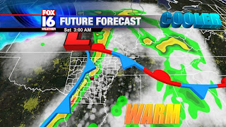
(Friday night's setup on the horizon)
On Friday a quick surface low will get its act together in Texas and rush into Missouri during the overnight hours. Underneath the fast moving system will be a warm front and a cold front rushing through Arkansas. As these frontal boundaries come into our state Friday and Saturday morning there will be a chance at strong thunderstorms.
Let's be clear, I'm not waving a red flag saying that a tornado outbreak is coming - far from that. We just need to be on guard in a couple days. The wind profile is not overly impressive on Friday night and the instability (energy for the storms to lift) is pretty low, so there are several ingredients that are not coming together here.
The point I'm trying to make is just pay attention to the sky late Friday night and Saturday morning. With the way this winter season has gone down it wouldn't hurt to check in with FOX 16 every now and again to confirm what's going on outside your door.
Obviously Jeff and I will be in the weather center watching this development unfold. Make sure to follow us on twitter and keep watching FOX 16 for more updates on the situation. Until then have a good week and don't forget your umbrellas!


No comments:
Post a Comment