Sunday, January 27, 2013

Tuesday Storm Potential


A strong cold front will approach Arkansas Tuesday. As the front moves into the warm, moist air accompanied by a strong jet stream aloft, potentially strong to severe thunderstorms will develop.


Storms will develop over Western and Northwest Arkansas during the early afternoon and push Eastward during the late afternoon and evening hours. Below is the forecast radar for Tuesday afternoon pushing into Western Arkansas.


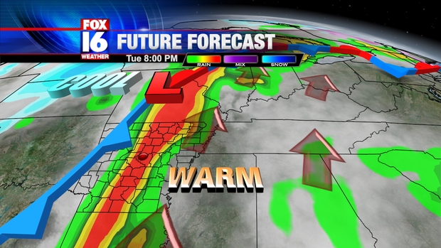
Storms will develop into a squall line with locally damaging wind gusts as the storms push Eastward into Central Arkansas. The greatest risk for storms in Central Arkansas is during the evening hours, especially between about 6PM and 10PM. Below is our computer model projection for 8PM, showing the storms over Central Arkansas.


 Storms will push through Eastern Arkansas during the late evening hours and out of the State by shortly after Midnight.


 Along with strong damaging wind gusts, isolated embedded tornadoes are possible along the squall line due to the strong wind shear. Below is the Storm Prediction Center severe weather outlook for tomorrow. All of Arkansas is under a risk area for severe storms. A moderate risk has been issued for parts of Central, Southern and Eastern Arkansas where the severe threat is greatest


Very strong wind shear along with warm, moist air in place ahead of the front will create an environment conducive for spin-ups to develop along the squall line. These spin-ups may create tornadoes, and due to the strong wind field in place any tornado that does form may be strong to violent (EF2 or higher) The storm prediction Center has placed much of Arkansas in a enhanced risk for EF2 or stronger tornadoes for Tuesday evening as indicated in the shaded area below.


The tornado threat will be highest across Central, Eastern and Southeast Arkansas, where the combination of wind shear and instability will be maximized. Below are tornado probabilities as indicated by the Storm Prediction Center.

(probability of a tornado within 25 miles of a given point)

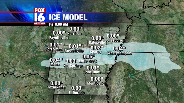
Some locally heavy rains are also possible with over 2 inches possible in some spots. Some brief ponding of water on roadways is possible, but significant flooding is not expected. Storms will exit the State by shortly after Midnight, followed by sharply cooler air for Wednesday morning.

Friday, January 25, 2013

Warm Up, Potential Storms

A major change in our weather is underway as we head through the weekend. Our rather cold pattern will be replaced by much warmer one by late in the weekend through early next week.


Warm, moist air will surge Northward out of the Gulf of Mexico Saturday night into Sunday as a warm front moves through from the South. Southerly winds will overspread Arkansas by early in the week, bringing in the much warmer air.


A cold front will approach Arkansas by Tuesday. As the front moves into the warm, moist air accompanied by a strong jet stream aloft, potentially strong thunderstorms will develop.


There is some uncertainty regarding the next storm system for next week. Some of the models are showing a weaker front, which would lessen the threat of severe weather.

Wednesday, January 23, 2013

Cold Blast, Some Wintry Weather Possible

A strong surge of cold air follows a cold front for Thursday, with high temperatures remaining in the 30s in most spots. Northerly winds will make it feel more like 20s.
The front will stall near the Louisiana border Thursday as a weak wave of low pressure moves along the front.


As the low pressure passes to our South late Thursday night, light rain and some freezing rain will move across the area. Accumulations are expected to be minor, with less than a tenth of an inch. This will be enough to cause some icy spots mainly on bridges and overpasses.


Temperatures early Friday morning will be near or below freezing across Central Arkansas, but mainly above freezing South of Little Rock.


Temperatures will quickly warm above freezing by mid-morning Friday, bringing an end to any concerns of ice.

Tuesday, January 22, 2013

Big Temperature Swings, Minor Winter Weather

A brief warm up is underway for Wednesday, but it won't last long as a series of front move through the State. This will result in a temperature roller-coaster ride through the rest of the week


A cold front will approach from the North Wednesday night and Thursday morning. Much colder air will filter in behind the front into Central Arkansas.


A tight temperature gradient will exist across the front Thursday with temperatures near 60 in Southern Arkansas, but only in the upper 30s to 40s for Central Arkansas. Temperatures in North Arkansas will likely not climb much above freezing.


A weak area of low pressure will move along the front Thursday night and into Friday morning. This will bring a few showers into the State late Thursday night. Temperatures will be cold enough that light rain may mix with sleet, mainly North of I-40.


Precipitation amounts are expected to be light, mainly less than one tenth of an inch. Temperatures will also be generally above freezing through Friday morning, so ice accumulations are not expected at this time. It is possible that some elevated surfaces may become slick, mainly across Northern Arkansas early Friday morning. Showers will come to an end later Friday morning with highs into the 50s by the afternoon. Yet another cold front approaching from the North will bring another shot of colder air for Saturday.

Monday, January 14, 2013

Wintry Week Ahead

More Wintry weather likely for Tuesday and potentially again later this week. Another wave of low pressure will move along a stalled front to our Southeast. This will spread another round of Wintry precipitation back into Arkansas by Tuesday morning.


The pink areas indicate a mix of freezing and sleet.  The greatest threat for significant icing is over Ashley and Chicot Counties in Southeast Arkansas where the National Weather Service has issued an ice storm warning through Tuesday evening.


Enough icing may occur in the warning area that travel will become dangerous, as well as ice buildup on trees and power lines is likely. Power outages are possible in the warning area with more than a quarter inch of ice accumulation possible. The area shaded in purple indicates a Winter Weather Advisory, where some sleet and freezing rain is likely, but accumulations will not be enough to cause significant problems. Little Rock and the metro area is not included in the advisory at this time. A few slick spots are possible on some of the roads, especially overpasses, but overall impact will be low. All precipitation will end across the State by Tuesday evening.

The Winter Weather  may have even more in store for Arkansas later in the week. A strong upper air disturbance will approach from the West early Thursday morning.


This disturbance will develop a wave of low pressure along the front stalled to our Southeast. Some of the computer models are now indicating that moisture associated with the wave will wrap around the upper disturbance.


This would bring potentially heavy snowfall into Central Arkansas Thursday. This solution is now indicated by a couple of computer models, including our own high resolution Microcast. Below is the forecast radar for 10 AM Thursday.


Some of the computer models show a much different solution, however, in which the moisture does not wrap around the upper level low. This would result in very little precipitation for Arkansas. Below is a different computer model run for the same time Thursday morning.


Due to the completely different solutions offered by the computer models, the forecast for Thursday is very low confidence. It is important, however, to keep in mind that a Winter Storm is at least possible later this week. While it is far too early to talk snow amounts with any degree of reliability, our computer model does show some significant amounts.


Keep in mind this is just one forecast model, and not an actual forecast. The big question is how much moisture warps around the upper air low pressure system, which will determine whether or not we get accumulating snowfall or barely anything at all.

Friday, January 11, 2013

Strong Cold Front Saturday

 UPDATE: A Tornado Watch is in effect for parts of Central Arkansas through early this evening. Thunderstorms are likely through the evening hours as a strong cold front approaches. Storms may produce gusty winds, heavy rainfall with an isolated tornado threat.

(Current Watches and Warnings-updates every 5 minutes)


A strong cold front will push into the State Saturday, bringing and end to our unusually mild weather across Arkansas. Showers and thunderstorms will develop along and ahead of a cold front advancing into Arkansas Saturday.


The storms will produce some locally heavy rainfall as the front slows down as it moves through Arkansas. A flash flood watch is in effect for Central Arkansas through tonight. Rainfall amounts will be heavy in some spots with 2 to 3 inches of rain likely. Computer projected rainfall amounts show heaviest rain across Central and Eastern Arkansas through 6 AM Sunday morning.


A few storms may also be strong to severe, with warm & moist Gulf air ahead of the front. Strong, gusty winds will be the primary severe threat. the Storm Prediction Center has placed parts of Central Arkansas under a SLIGHT risk for Saturday, especially during the afternoon and evening hours.


The front will move through Saturday night with colder air filtering in Sunday. Temperatures will drop to near 40 by Sunday morning, with little change during the day. The forecast map for Sunday morning shows Arkansas on the cold side of the boundary with some lingering rain for Southeast Arkansas.


It appears now that the moisture will stay far enough East that freezing rain will not be an issue for Arkansas Sunday into Sunday night.

Thursday, January 10, 2013

Weekend Cold Front

A strong cold front will push into the State Saturday, bringing and end to our unusually mild weather across Arkansas. Showers and thunderstorms will develop along and ahead of a cold front advancing into Arkansas Saturday.


The storms may produce some locally heavy rainfall as the front slows down as it moves through Arkansas. A few storms may also be strong to severe, with warm & moist Gulf air ahead of the front.
The front will move through Saturday night with colder air filtering in Sunday. Temperatures will drop through the 40s Sunday with some lingering showers behind the front. The forecast map for Sunday afternoon shows Arkansas on the cold side of the boundary with some lingering rain, especially for Eastern and Southeast Arkansas.


The front will stall Southeast of Arkansas by early Monday morning with a wave of low pressure moving up along the front. As moisture is thrown back into the cold air, temperatures may be just cold enough for some freezing rain over parts of Arkansas.


The specific timing of the wave of low pressure moving along the front is still very much in question with significant differences in computer model projections this far out. The Westward extend of the precipitation will also be key in determining where freezing rain is most likely. As the forecast confidence increases, we will be able to better determine the timing of the Wintry Weather and what parts of Arkansas would be most at risk. Right now, the highest chances for icing are for North Central Arkansas Monday night into early Tuesday. This preliminary forecast can change significantly over the next couple of days so stay tuned to the forecast.

Wednesday, January 9, 2013

Afternoon Storm Potential

Storms are likely to develop across parts of Central Arkansas later this afternoon and this evening, An area of low pressure over Oklahoma with a trailing cold front across Texas will push Northeast into Arkansas this afternoon. Warm, moist air from the Gulf of Mexico is pushing Northward trough Louisiana and Arkansas ahead of the cold front. This will create enough instability in the atmosphere for the cold front to begin to trigger thunderstorms later today. Below is the surface map as of 11AM Thursday showing some rain lingering across Eastern Arkansas and the front to our West.

Despite cloud cover, temperatures will warm well into the 60s to near 70 in some spots.  Storms for Central Arkansas will be most likely during the late afternoon into the evening as the front pushes into Arkansas. Below is the forecast map for 6 PM Thursday showing storms moving across Central Arkansas.


A few of the storms may be strong with isolated hail and wind gusts the main threats. The Storm Prediction Center has issued a SLIGHT risk for parts of Central Arkansas through this evening.


Storms will push through Eastern Arkansas later during the evening hours and out of Arkansas before Midnight.

A strong, but slow moving storm system is set to bring some potentially heavy rainfall and some thunderstorms for parts of Arkansas tonight into Thursday. Mainly light rain, drizzle and mist can be expected into Wednesday afternoon as low pressure over Texas spreads moisture over the State. Most of the heavier rains will stay Southwest of Arkansas through today


The low pressure will move Northwest tonight bringing warm air into Central Arkansas ahead of a cold front. Showers and some thunderstorms are likely ahead of this front Thursday morning.


Showers and thunderstorms will slowly move across the State Thursday, with some potentially strong storms possible. Hail and wind gusts will be the main threat. Heavy rainfall is also expected in some spots due the slow movement of the rain. Rainfall amounts may exceed 3 inches in some spots through Thursday evening.


Widespread flooding is not expected at this time due mainly dry conditions and low water levels of rivers and streams, however, some brief ponding of water on roadways is possible during heavier rains.

Monday, January 7, 2013

Mid Week Rain & Storms

A strong, but slow moving storm system is set to bring some potentially heavy rainfall for parts of Arkansas Wednesday into Thursday morning. An area of low pressure will intensify over Texas and push warm front Northward towards Arkansas by Wednesday afternoon


The low pressure will move Northwest Wednesday night bringing warm air into Central Arkansas ahead of a cold front. Showers and some thunderstorms are likely ahead of this front Thursday morning.


A few isolated strong storms are not out of the question early Thursday morning, but the main concern will be the heavy rainfall. Widespread 2 inch amounts with locally up to 4 inches is possible by the time all the rain ends Thursday afternoon.


Unusually mild temperatures will follow this system with highs well into the 60s Thursday and Friday.