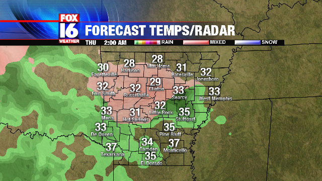
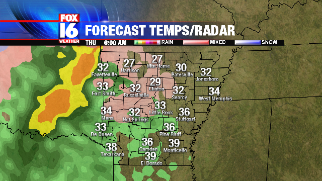
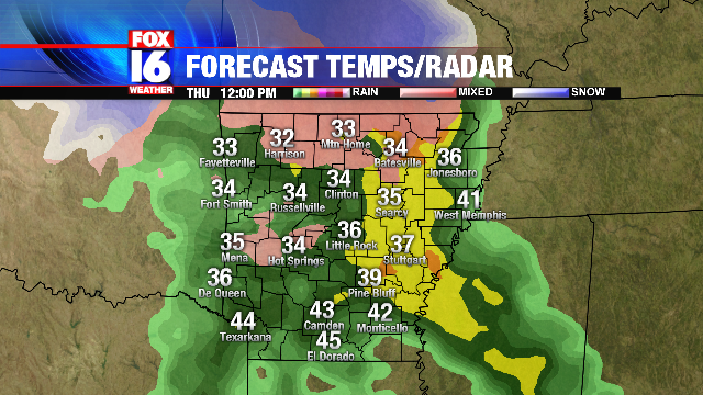
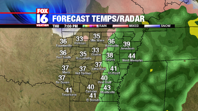
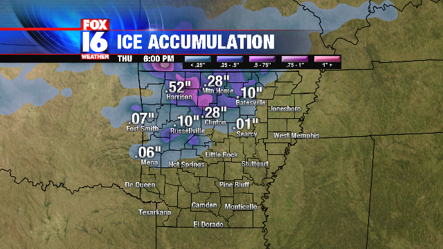
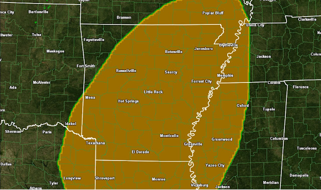
A wet and relatively cool mid-Summer afternoon across Central Arkansas Friday with widespread rain and much below normal high temperatures. A large area of rain is overspreading the State this afternoon and this evening, with little in the way of any thunder.
Most of the rain has been light, but a few areas of some heavier rain are still possible through tonight. A flash flood watch is in effect for much of the Western half the State through this evening.
Due to the mostly light and steady nature of the rainfall, any flooding problems should be very isolated. This is exactly the kind of rain we need to alleviate the dry conditions from the last few weeks.
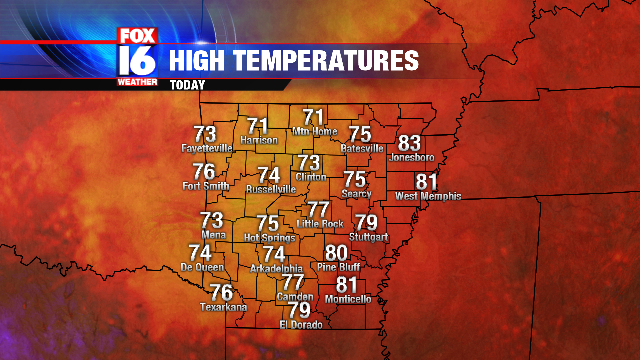
The clouds and rain have kept temperatures quite cool for this time of year. High temperatures so far today have been mainly in the 70s.
The high in Little Rock so far Friday has only reached 77 degrees. This is the first time the high temperature in Little Rock failed to hit a daily high of at least 80 in July since 2009. The last time the high temperature in Little Rock did not hit 80 in July was July 20th 2009 with a high of 79. Normal highs this time of year are in the low to mid 90s.
Friday, July 26, 2013
Thursday, July 11, 2013
Drought Develops in Arkansas
Several weeks of dry conditions are leading to worsening drought across Arkansas. Even though a few spots have received some rainfall over the last couple of days, the isolated and brief nature of the rain has not been enough to alleviate the dry conditions. The U.S. Drought Monitor now shows parts of Arkansas under moderate drought, with dry conditions across much the State. The areas considered dry will go into drought conditions soon if no significant rain occurs.
Drought conditions are nowhere near as bad as they were this time last year. By mid- July of 2012, much of Arkansas was under severe to extreme drought.
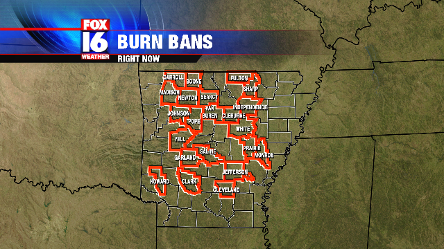
Fire danger is quickly increasing due to the dry weather. Burn bans are now in effect for numerous Arkansas Counties.
The outlook for any significant rain is slim going into next week, which will likely lead to worsening drought conditions and more burn bans.
Drought conditions are nowhere near as bad as they were this time last year. By mid- July of 2012, much of Arkansas was under severe to extreme drought.
Fire danger is quickly increasing due to the dry weather. Burn bans are now in effect for numerous Arkansas Counties.
(County Burn Bans as of 10PM Friday July 12th)
Thursday, June 27, 2013
Temperatures in Central Arkansas reached the 100 degree mark for the first time this year so far in many spots. Little Rock National Airport recorded a temperature of 100 degrees at 3 PM with a heat index of 108.
Heat Index values across Central Arkansas are topping 110 in some spots, which can be dangerous if with prolonged outdoor exposure or strenuous activity.
Thunderstorms will become likely during the late evening and overnight hours as a disturbance approaches from the Northwest. Some storms may produce some strong gusty winds. Below is the forecast radar for around Midnight.
The Storm Prediction Center indicates a SLIGHT risk for severe storms through tonight in the area shaded in yellow.
Monday, May 20, 2013
Severe Weather Risk
TUESDAY IS A FOX16 SEVERE WEATHER ALERT DAY
A slow moving front moving into the State accompanied by a potent upper level disturbance will bring another round of strong to severe thunderstorms to parts of the State Tuesday.
Below are the current watches and warnings.
The front will move into Arkansas Tuesday as a wave of low pressure moves up along the front. This will trigger another round of storms by late Tuesday afternoon into Tuesday evening. Storms will begin to develop during the late afternoon hours.
The storms will initially pose a hail and tornado risk, transitioning into a more of a wind risk by later in the evening.
The Storm Prediction Center has issued a MODERATE Risk area for parts of Central Arkansas Tuesday.
The main severe weather risks will be gusty winds and hail. A tornado threat may also come into play, but this is still somewhat in question. Pay close attention to the weather tonight and tomorrow and be ready to heed any warnings that are issued.
Friday, May 3, 2013
Little Rock smashes temperature records
The incredibly late season cold snap is breaking numerous records for Arkansas. Nearly 5 inches of snow was reported in some spots in Northwest Arkansas this morning marking the first ever officially recorded snowfall in the State in the month of May.
Cold temperature records are also falling. Little Rock set numerous records today including:
- Tied the record low for the day of 41, set in 1929
- High of 48 set broke the record minimum high temperature for the Month. Previous record was 52 set on May 2 1994.
- Average temperature for the day of 45 broke the record for coldest average daily temperature for the Month of 46.5 set on May 2 1994
More record cold is expected for tomorrow as temperatures drop into the 30s overnight. The record low temperature for the month of May in Little Rock is 39 degrees, set on May 1 1903. The forecast low temperature for Little Rock tonight is 38.
Thursday, May 2, 2013
Record Setting May Snowfall becoming more likely for parts of Arkansas
Snowfall in May in the State of Arkansas just doesn't happen, but that could very well change by Friday morning. John Robinson of the National Weather Service in Little Rock went in search of records of a May snowfall in the State, but could not find a report of snow later than April 30th. On April 30th 1903, a trace of snow was reported in Fayetteville and Harrison. The latest measurable snowfall was recorded on April 24th 1910 in Corning, Arkansas. As for Little Rock, the latest snowfall ever recorded was on April 19th 1983. ALL of these records are in jeopardy. Here is a look at some various computer model snowfall projections through Saturday morning.
(RPM snowfall projection through 8 AM May 4th 2013)
(NAM snowfall projection through 8 AM May 4th 2013)
(GFS snowfall projection through 8 AM May 4th 2013)
As you can see, computer models are in agreement of a record late season snowfall across parts of Arkansas. Although measurable snowfall is not expected for Central Arkansas, a brief snow mix is not out of the question with the cold air in place. The ground is far too warm for any snow to stick though.
Wednesday, May 1, 2013
Winter in May
An unusually strong cold front will move through the region, bringing some of the coldest air ever observed in May for parts of Arkansas. The cold front will move through Thursday bringing rain and much colder temperatures. The front will move into Eastern Arkansas on Friday, but rain will linger behind the front as moisture wraps around an upper level low pressure system to our Northwest. Temperatures will become cold enough that rain will likely mix with snow across parts of Northwest Arkansas.
Temperatures behind the front will dip well down into the 30s and 40s across Central Arkansas by Friday morning.
Gusty Northwest winds will make it feel even colder with wind chills down into the 20s. Heavy Jackets and even Winter coats will get at least one more use this season.
Snow accumulations are quite possible across Northwest Arkansas, Oklahoma, and Missouri. Friday morning. Computer models vary in the location of the heaviest snow, but a couple of inches for parts of Northwest Arkansas is certainly possible. This would be an historic event since no observing station in Arkansas has ever recorded May snowfall since records began. Below is one computer model projection of possible snowfall.
Snowfall amounts, if any in Arkansas, are still uncertain since it depends highly on the track of the upper level low pressure system.
Cold air will remain in place through the weekend with record cold for Central Arkansas. The all time coldest temperature for May in Little Rock set in 1903 may be tied or even broken by Saturday morning.
Record cold temperatures are likely once again for Sunday morning in many spots. Fortunately, these temperatures should not be cold enough to cause significant damage to outdoor plants in Central Arkansas. High temperatures will remain about 20 degrees below average for this time of year.
Milder, more seasonable temperatures will slowly return by early next week as the upper low finally pulls away.
Saturday, April 27, 2013
Tornado Watch in effect for parts of Arkansas through 11 PM. Storms developing along a front will continue mainly for parts of East Central Arkansas through this evening. Storms may contain hail, gusty winds as well as frequent lightning. A brief tornado is also a possibility in the watch area. Below are the current watches and warnings for Arkansas.
All storms will move out of the State by Midnight.
All storms will move out of the State by Midnight.
Tuesday, April 16, 2013
Thursday Storm Potential
UPDATE: Remaining severe risk shifts into Eastern Arkansas.
A strong cold front will pushing across Arkansas with a line of thunderstorms. Most of the storms so far today have remained below severe limits due to limited heading ahead of the front. The front will push East through the afternoon into Eastern Arkansas. Most storms will push out of Arkansas by about 7 PM as the front moves East.
Much colder air is following the front. As of early afternoon, temperatures across Western Arkansas were falling into the 40s and 50s
Temperatures will continue to fall through the evening hours as the front clears the State by later this evening.
A quieter weather pattern is expected for the weekend, with mostly sunny skies but below average temperatures.
Wednesday, February 20, 2013
Winter Storm Update
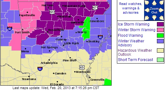
A significant Sleet and snow is transitioning to mostly freezing rain tonight with significant ice accumulations likely across North Central Arkansas. An ice storm warning is in effect in the bright purple area indicated below.
Lesser ice accumulation is expected in the purple areas, indicating a Winter Weather Advisory. Mixed precipitation will transition to mostly freezing rain overnight. Temperatures will be close to the freezing mark Central Arkansas with slightly below freezing temperatures North.
Freezing rain will pick up intensity by Thursday morning, with significant ice accumulations likely in the ice storm warning area. Temperatures South of I-40 will be very close to freezing, which may result in glazing of trees and power lines. most surface roads will be wet, with icy spots possible on elevated surfaces.
North of I-40, where temperatures are likely to be below freezing, more significant ice accumulations are expected. Tree limbs will start falling, resulting in power outages. Travel conditions may become dangerous in spots, especially secondary roads and bridges. Temperatures will warm above freezing across most of the State by Noon with just cold rain and improving conditions.
Rain will diminish by late in the evening hours as it pushes East out of the State. Temperatures will stay generally above freezing Thursday night, so re-freezing is unlikely in most spots.
Total ice accumulations will be greatest North of I-40 through North Central Arkansas. Computer model ice accumulations through Thursday are shown below. Computer model trends have been showing LESS ice accumulation for Central Arkansas South of I-40 including the greater Little Rock area.
Ice accumulations over one quarter inch is sufficient to bring down tree limbs and power lines.
Tuesday, February 19, 2013
Mid-Week Ice
A
storm system will bring snow, sleet and freezing rain to parts of the
State for the middle of this week. A Winter Storm watch is in effect
mainly for areas North I-40 for Wednesday evening into Thursday. A mix
of light snow and sleet will move into Western and Central Arkansas
during the mid-morning hours into the early afternoon.
Accumulations are likely to be minor, but some slippery spots are possible. The first band of precipitation will diminish by late afternoon, but will increase again Wednesday night with mainly rain Southern Arkansas, a mix of freezing rain and rain Central Arkansas with primarily freezing rain Northern Arkansas.
A freezing rain and snow mix is likely close to the Missouri border, with freezing rain for Northern and parts of Central Arkansas through Thursday morning.
Rain and freezing rain will transition to mainly rain by Thursday afternoon, although a few spots over Northern Arkansas may remain freezing rain.
Significant ice accumulations over half an inch are possible in the Winter Storm Watch area. This is enough to cause damage to tree limbs and power lines, as well as cause travel problems. Below is the computer projected ice accumulations through Thursday evening.
Power outages are likely across much of North Central Arkansas, mainly North of I-40. South of I-40, ice accumulations will be less, but some glazing of trees and power lines is possible. Bridges and overpasses may be icy Thursday morning. Exact temperatures over Central Arkansas will be critical in determining how much ice accumulates. A difference of even a degree or two will make the difference between significant icing or just cold rain. Rain will come to an end Thursday night with milder temperatures for the end of the week.
Sunday, February 10, 2013
Tuesday Snow Potential
A storm system moving in from the Southwest Tuesday will interact with some colder air moving in from the North. This will result in rain changing over to snow for parts of the State. However, accumulating snow will likely be confined to Northern and Northwest sections of the State. Computer models have been trending warmer for Central Arkansas, keeping all precipitation as rain. Below are several computer models showing accumulated snowfall through 9 AM Wednesday. All of the models show snow staying North, with only minor accumulations.
(NAM snow depth at 9 AM Wednesday)
(GFS snow depth at 9 AM Wednesday)
(RPM snow depth at 9 AM Wednesday)
Bottom line is that any snow at all looks unlikely South of I-40, with minor accumulations North. Higher elevations over Northwest Arkansas stand a shot at seeing a couple inches of accumulation.
Saturday, February 9, 2013
Sunday Morning Storms
A cold front will sweep through Arkansas Sunday morning, bringing a round of some rain and a few thunderstorms. A narrow wedge of warm air will move Northward just ahead of the front, allowing for the possibility of a few strong storms, especially over Southern Arkansas. Below is the Storm Prediction Center severe weather threat for Sunday.
The Storm Prediction Center shows much of the Southern half of Arkansas in a Slight Risk area for Sunday. The main risk from the storms will be some gusty winds, but there is also a low end tornado threat mainly in Southeast Arkansas South and East of Camden and Monticello.
Storms will approach Western Arkansas during the early morning hours. Below is a high resolution computer model forecast for 6 AM Sunday
Showers and storms will reach Central Arkansas by the mid-morning hours. Below is the forecast radar for 10 AM Sunday.
Storms will move Eastward into the afternoon, reaching Eastern and Southeast Arkansas by shortly afternoon. Below is the forecast radar for 1 PM Sunday.
Some heating will take place as the storms move into Southeast Arkansas, meaning a greater potential for some strong thunderstorms. Tornado potential will increase during the mid-day hours as the storms move through Southeast Arkansas. Most storms will clear the State by Mid Afternoon with breezy and mild conditions.
Sunday, January 27, 2013
Tuesday Storm Potential
A strong cold front will approach Arkansas Tuesday. As the front moves into the warm, moist air accompanied by a strong jet stream aloft, potentially strong to severe thunderstorms will develop.
Storms will develop over Western and Northwest Arkansas during the early afternoon and push Eastward during the late afternoon and evening hours. Below is the forecast radar for Tuesday afternoon pushing into Western Arkansas.
Storms will develop into a squall line with locally damaging wind gusts as the storms push Eastward into Central Arkansas. The greatest risk for storms in Central Arkansas is during the evening hours, especially between about 6PM and 10PM. Below is our computer model projection for 8PM, showing the storms over Central Arkansas.
Storms will push through Eastern Arkansas during the late evening hours and out of the State by shortly after Midnight.
Along with strong damaging wind gusts, isolated embedded tornadoes are possible along the squall line due to the strong wind shear. Below is the Storm Prediction Center severe weather outlook for tomorrow. All of Arkansas is under a risk area for severe storms. A moderate risk has been issued for parts of Central, Southern and Eastern Arkansas where the severe threat is greatest
Very strong wind shear along with warm, moist air in place ahead of the front will create an environment conducive for spin-ups to develop along the squall line. These spin-ups may create tornadoes, and due to the strong wind field in place any tornado that does form may be strong to violent (EF2 or higher) The storm prediction Center has placed much of Arkansas in a enhanced risk for EF2 or stronger tornadoes for Tuesday evening as indicated in the shaded area below.
The tornado threat will be highest across Central, Eastern and Southeast Arkansas, where the combination of wind shear and instability will be maximized. Below are tornado probabilities as indicated by the Storm Prediction Center.
(probability of a tornado within 25 miles of a given point)
Some locally heavy rains are also possible with over 2 inches possible in some spots. Some brief ponding of water on roadways is possible, but significant flooding is not expected. Storms will exit the State by shortly after Midnight, followed by sharply cooler air for Wednesday morning.
Subscribe to:
Posts (Atom)


