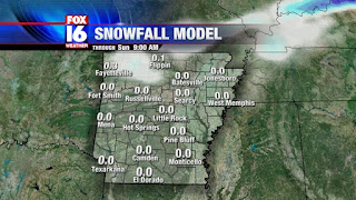
Earlier this week, I mentioned the chance for snow on Saturday night...If you recall I said it was basically slim to none for Northern/Northeast Arkansas.
(Latest FOX 16 weather model showing no snow for Central Arkansas)
Several days have come and gone and nothing has changed. An unsettled surface low will still take center stage near the Gulf Coast on Saturday. Due to the lift and abundant moisture supply, we'll see numerous bands of showers and thunderstorms wrap around the low. Eventually this rain will spread into Arkansas. When it comes to snow, we expect a dusting, at best, to fall in extreme Northern Arkansas. Nothing will stick to ground since temperatures will be above freezing.
If you're wondering about the timing of the rain well here is our exclusive FOX 16 weather model giving you a glimpse at what to expect.
EARLY MORNING: We'll begin Saturday with a cloudy sky and chilly temperatures in the 40s. Most of the heavy rain is still hours away from Central Arkansas.
NOON: Rain becomes widespread across parts of Central and Southern Arkansas.
LATE EVENING: Rain still scattered across the state with a little mix of sleet in Northwest Arkansas. Temperatures will be above freezing so it won't stick to the roads.
So that is a break down of your Saturday. As for Sunday, we'll dry out and watch the clouds clear out with temperatures back to the low 50s.


No comments:
Post a Comment