TONIGHT: The weather will be mostly clear and quite chilly for this time of year. Thermometers will sink down to the upper 40's so think twice before you open those windows before you go to bed.
TOMORROW: More wonderful weather on tab. We'll receive another full dose of sunshine with hardly a cloud in the sky. Temperatures will be slighty warmer with high's generally in the upper 70's.
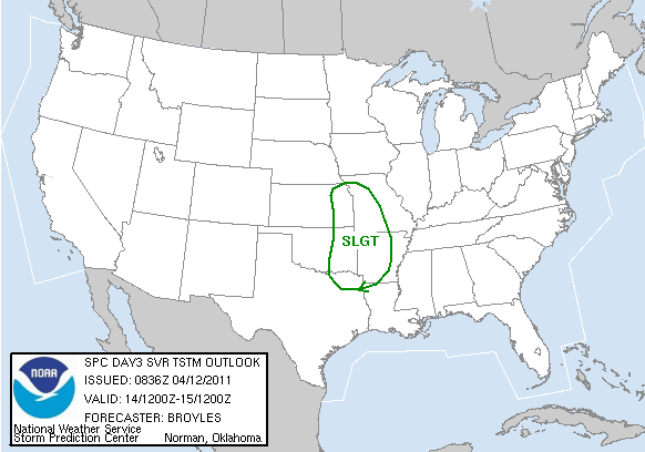
REST OF THE WEEK: A very strong area of low pressure will form in the Central Plains late Thursday evening. This feature will spawn a cold front and, eventually, strong thunderstorms. The Storm Predicition Center in Norman is already on top of this and has Western Arkansas in a slight risk area (aka thunderstorms could turn severe). Judging by the latest model data, the worst threat for damaging winds, hail and tornadoes appear to be in the Eastern Kansas/Western Missouri border. Still we could see one or two nasty storms break out in Western Arkansas on Thursday evening...that is...if they managed to develop that quickly. Most computer models (the more reliable ones anyway) are suggesting another overnight episode that we had early on Monday morning. In this case, the thunderstorms most likely won't get here until midnight or early on Friday morning. If this scenario turns out to be true then all we would have to worry about is damaging straight line winds and small hail.
We're still collecting data about this rapidly developing system. We'll let you know more in the coming blog entries.
We'll dry out by Friday afternoon and feel temperatures plunge into the 60's.
WEEKEND: We'll be into a dry pattern with a good supply of sunshine. Otherwise, temperatures will stay in the 60's for the most part.
NEXT WEEK: Majority of the models are in agreement that a broad upper level trough will sink down into the Central/Southern Plains and stay there for a lengthy period. In other words, we'll go through a wetter pattern with a series of showers and thunderstorms moving in the state. Temperatures will be on par but not exceptly warm most likely in the 70's.
No comments:
Post a Comment