TODAY: The rest of this afternoon and evening will be very nice. Temperatures will continue to hover in the upper 70's and flirt with 80 degrees while the sunshine will beam overhead.
TONIGHT: Our thermometers will only slip down to the low 60's/upper 50's. Meanwhile we'll see an increase in cloud cover.

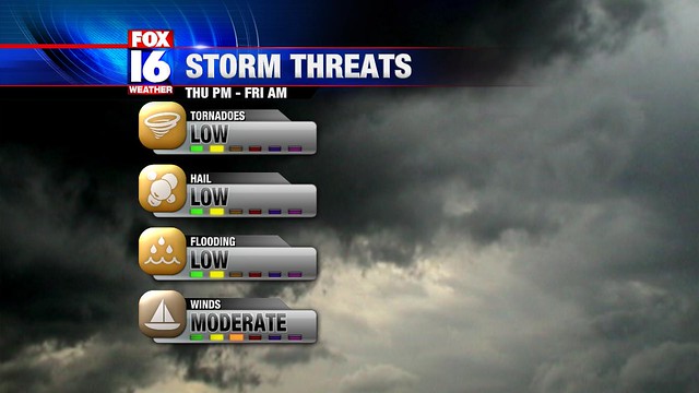
THURSDAY: As we discussed earlier, a steep change in low pressure will occur in East Kansas. Inevitably this change will bring in breezy winds and warmer temperatures near 80 degrees in Little Rock. Later toward the evening we'll watch thunderstorms blossom near the low and along a developing cold front to the south. These intense storms will be capable of producing fairly large tornadoes and golf ball size hail. Luckily these damaging thunderstorms will likely affect Northeast Oklahoma and East Kansas (hence the moderate outlook from SPC). The northwest tip of Arkansas may see storms drift into their neighborhood but they should loose some of their intensity. Eventually, more thunderstorms will erupt and form into a line later Thursday night. This batch of rain and lightning won't be nearly as bad as what we expect in NE Oklahoma. At this point the best timing for these storms will be around midnight or a couple hours earlier.

FRIDAY: We'll dry out during the day and feel temperatures stay in the upper 60's.
WEEKEND: Latest indications reveal a relative mild weekend with temperatures struggling to get to 60 on Saturday and getting close to 70 on Sunday. Sunshine will be prevalent as well with a light breeze on Saturday.
In the next blog entry I'll talk about next week's weather pattern in more detail. Until then I love your faces and have a wonderful Tuesday.
No comments:
Post a Comment