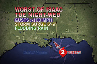
(GFS model showing Isaac slamming Louisiana late this week)
Tropical models that once pegged Isaac to hit Pensacola, FL now are spread all over the place and have Louisiana in the mix for potential landfall spots. So what happened? Where did this radical change come from?
All tropical storms are dictated by the upper level winds from either low or high pressure. In this case, a high pressure in the mid-level of the atmosphere was expected to break down and allow Isaac to move northward once it hit the gulf. The latest information now shows that the high pressure will remain firm and steer Isaac more westerly.
When you put it all together, Arkansas could actually feel effects of Isaac after all. Half of the global models out there show the remnants of Isaac curling toward Arkansas bringing flooding rains by Friday night. On any other day that would be fantastic, but the fact that high school football kicks off at the same time could be a little problematic for folks.
Needless to say, don't write home Isaac just yet. There could more twists and turns before we know exactly where it will end up. Make sure to stay up to date on FOX 16 and look for more blog posts in the future.


No comments:
Post a Comment