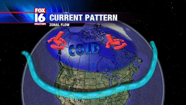
So far this winter season, there has not been any widespread outbreak of cold air across the Lower 48, and no significant arctic intrusion is forecast right through New Years. The bitterly cold, arctic air is locked up in Canada, keeping Northern parts of the Country unusually mild heading into Christmas. The reason for the lack of cold is the current upper atmospheric pattern which now features a jet stream that is fairly West to East across North America. Such a pattern is called "Zonal Flow", and is not conducive for cold, winter like weather.
So far this season, there have only been 2 significant snow storms, one of which was the October snow in New England, and the other that hit the Southwest and Southern Plains earlier this week. In order to bring down the real cold air from Canada, the jet stream needs to buckle allowing storm systems to bring the Arctic air South. A pattern that drives the cold air South involves something called High Latitude Blocking, in which high pressure builds in the upper levels over parts The Arctic. Such a pattern sends the jet stream into the high latitudes and back South, allowing the Arctic Air to penetrate into the lower latitudes.

There are no indications of such a pattern setting up through Early January, keeping the chances of a large blast of cold air quite low over the next couple of weeks.
No comments:
Post a Comment