Thursday, March 15, 2018

St Patrick's Day Weekend Forecast


The weekend is almost here with some very Spring like temperatures, but clouds and showers return for Friday morning with an increase in Gulf moisture. 

Showers move out by around lunch time, with some sunshine by late afternoon. The evening looks mainly dry, but a few isolated storms may develop just ahead of a push of dry air. 


Even though storm coverage will be very limited, any storm that does develop could be strong. The main risk from storms would be some large hail and gusty winds.

 A cold front moves into the State Saturday, but it won't have much moisture to work with. A few clouds around Saturday, but otherwise dry and quite mild with highs in the 70s. A little cooler North.


The front moves South by Sunday morning with some cooler air, but then returns North as a warm front Sunday evening. This will bring back showers and possibly some thunderstorms by late in the day.

Monday, October 13, 2014

At least 2 Tornadoes Confirmed

A line of storms produced wind damage and isolated tornadoes across Arkansas Monday morning. At least 2 tornadoes have been confirmed so far. Additional tornado tracks may be found over the next couple of days. Here are the preliminary storm reports from Monday


The National Weather Service in Little Rock confirmed an EF-1 tornado in Lonoke County just North of England. These are the results of the Lonoke County storm survey:

...NWS DAMAGE SURVEY FOR 10/13/2014 TORNADO EVENT...

.TORNADO #1...ENGLAND TORNADO

RATING:                 EF-1
ESTIMATED PEAK WIND:    85-90 MPH
PATH LENGTH /STATUTE/:  3.3 MILES
PATH WIDTH /MAXIMUM/:   150 YARDS
FATALITIES:             0
INJURIES:               0

START DATE:             OCT 13 2014
START TIME:             927 AM CDT
START LOCATION:         2.2 W ENGLAND AR /LONOKE COUNTY/
START LAT/LON:          34.5441 / -92.0074

END DATE:               OCT 13 2014
END TIME:               932 AM CDT
END LOCATION:           2.3 N ENGLAND AR /LONOKE COUNTY/
END LAT/LON:            34.5768 / -92.9649

SURVEY SUMMARY:

THE TORNADO BEGAN NEAR THE ENGLAND COUNTRY CLUB...WHERE LARGE TREE LIMBS
WERE BLOWN DOWN ALONG ARKANSAS HWY 161. ABOUT TWO MILES NORTH OF ENGLAND
...NEAR THE INTERSECTION OF CENTRAL HIGH SCHOOL ROAD AND HENDERSON ROAD
...THREE STRUCTURES THAT WERE DAMAGED BY AN EF1 TORNADO ON OCTOBER 2ND
WERE HIT AGAIN. PART OF THE METAL ROOF WAS TAKE OFF A TRACTOR SHED...
AND AN OLD FARM SHOP WAS BLOWN DOWN. A HOUSE HAD DAMAGE TO A WALL...PART
OF A FENCE BLOWN DOWN...DAMAGE TO A SWIMMING POOL...YARD ORNAMENTS WERE
BLOWN AROUND...AND TREE LIMBS WERE SNAPPED OFF. ALSO...A LARGE
INTERMODAL SHIPPING CONTAINER...BEING USED FOR STORAGE...WAS FLIPPED
ON ITS SIDE.

EF SCALE: THE ENHANCED FUJITA SCALE CLASSIFIES TORNADOES INTO
THE FOLLOWING CATEGORIES.

EF0...WEAK......65 TO 85 MPH
EF1...WEAK......86 TO 110 MPH
EF2...STRONG....111 TO 135 MPH
EF3...STRONG....136 TO 165 MPH
EF4...VIOLENT...166 TO 200MPH
EF5...VIOLENT...>200MPH

The National Weather Service in Shreveport also confirmed an EF-2 tornado in Ashdown in Little River County in Southwest Arkansas from early this morning. This tornado was responsible for one death and several injuries. The Weather Service is in the process of completing this survey.


Sunday, October 12, 2014

Severe Weather Alert Day


Update: Storm Prediction upgrades much of Central and Eastern Arkansas to MODERATE risk of storms with enhanced threat for strong to violent tornadoes by later this morning and early this afternoon.


A powerful storm system pushing through the Southern Plains pushes a strong cold front across Arkansas Monday. Warm, moist Gulf air will quickly pushing North ahead of the front is fueling storm development this morning. Storms will push through Western Arkansas during the morning hours.


The line of storms will quickly push East during the mid-morning hours toward Central Arkansas. The exact timing of the storms is uncertain, but the most likely time frame for Central Arkansas is between 8 AM and Noon today.


The line of storms pushes into Eastern Arkansas during the early afternoon.


The line of storms is moving into an environment of strong wind shear, which will enhance the threat for severe storms. The main risk will be damaging straight line winds with the threat for spin ups along the squall line. This means there will be a tornado threat with any stronger cells along the line. Isolated hail and flash flooding are also possible.


All storms will move out the State by Monday evening. Pay close attention to watches and warnings Monday and be prepared to take action if necessary. Make sure to also secure any loose items in and around your house.

Wednesday, October 1, 2014

Thursday PM Rain & Storms

A strong Fall cold front brings the threat of rain and storms into Arkansas Today, followed by a big cool down for the end of the week. The front will bring some strong to severe storms into the State this evening, with potentially strong, gusty winds. Storms will begin to develop during the late afternoon and early evening hours across Western and Northwest Arkansas


The storms will quickly organize into a squall line and rapidly push into Central Arkansas later during the evening hours.


Some of the storms will be strong to severe due to a warm and moist environment and an upper air disturbance associated with the front. The Storm Prediction Center has placed all of Arkansas under a Slight Risk area for severe storms for Thursday evening.


The main threat from the line of storms will be some potentially strong, damaging wind gusts. Hail is also possible, especially over Western Arkansas as the storms first begin to develop. The hail threat will diminish as the storms evolve into a line. An isolated tornado threat exists as well, due to some moderately strong wind shear in the atmosphere. This may cause a couple of spin ups along the line of storms. The threat from flooding is low due to fast moving nature of the front, but some isolated heavy rainfall is possible in a couple of spots.


Most of Arkansas has been quite dry over the last couple of weeks, and most areas could benefit from some rain. Many spots have a good shot of over an inch of rain, with some heavier amounts in a couple of spots. Here is one of the computer projections showing this scenario.


Most of the storms will push out by early Friday morning, followed by much cooler and drier air. A real Fall feel returns by Friday evening into Saturday. Highs by Saturday will stay in the 60s even with bright sunshine.


Thursday, July 31, 2014

Very Cool and Wet July

July 2014 will go down in the record books as a very cool and wet month. The average temperature for the month of July in Little Rock this July was only 77.5 degrees, over 5 degrees below average. This makes this July tied for the 3rd coolest on record.


This is also the coolest July in over a century. The top 2 coolest Julys are from 1905 and 1891! On of the reasons for the unusually cool temperatures was numerous days with lots of clouds and rain around. This is July was the wettest since 2009 in Little Rock and there was more rain this month than the last FOUR Julys combined. The total rainfall for the month fell just short of landing in the top 10 wettest list for July though, short by only a couple of tenths of an inch. 


7.19 inches of rain was recorded in Little Rock as of Thursday afternoon, which over twice as much as the average. August starts off a lot like July ended, with lots of clouds and temperatures that don't feel much like the middle of Summer. 

Tuesday, July 29, 2014

Unusually Cool and Wet

This Summer has certainly been an unusual one, with only a handful of very hot days so far. The temperature in Little Rock has only hit 95 degrees 3 times so far this Summer. For comparison, the temperature in Little Rock hit 95 degrees over 40 times by this time in the Summer in 2011! The cool trend continues as highs remain much below normal for the middle of this week. Clouds and showers will keep highs barely from getting to 80 on Wednesday, with highs likely staying in the 70s Thursday.


The record for the coolest high temperature Thursday is only 74, and if the clouds and showers hang on to the afternoon, the record may be broken for Little Rock. A slow warm up begins by the end of the week, but temperatures remain well below average.

Rain will approach by Wednesday afternoon with mainly just a few light showers, but a couple of isolated heavier showers are also possible. Strong storms are not expected. Most of the rain will move through overnight Wednesday into early Thursday.


Some showers will linger into Thursday afternoon, but lingering clouds will keep temperatures in the 70s.

Thursday, July 17, 2014

A Flash Flood Watch is in effect through Friday evening for parts of Arkansas including the Little Rock metro area. A disturbance moving along a front brings rain across the State tonight. Some of the rain will be heavy overnight with 1 to 2 inches of rain across much of Central Arkansas, and up to 3 inches South. Rainfall amounts will be less North of I-40. Due to the already rather saturated grounds from recent rainfall, the rains will create some spotty flooding problems, especially for Friday morning. Rain will begin to diminish by Friday afternoon. Some isolated thunder is possible in a few spots, but severe storms are not expected.


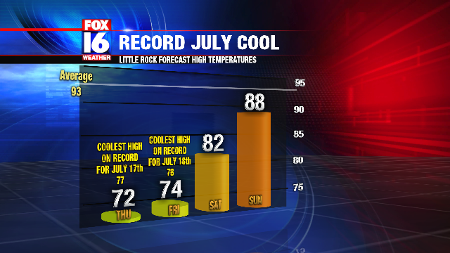
The wet weather is also keeping temperatures much below average for this time of year. It feels more like October rather than July with highs Thursday only in the 70s. Little Rock broke the record for the coolest high temperature on July 17th with a high of only 72. The previous record was 77. Another record low high temperature will likely be broken again for Friday as highs only reach the low 70s. The record low high for Friday in Little Rock is 78.


Temperatures will begin to get back normal by Sunday, with Summer heat returning by early next week.