A Flash Flood Watch is in effect through Friday evening for parts of Arkansas including the Little Rock metro area. A disturbance moving along a front brings rain across the State tonight. Some of the rain will be heavy overnight with 1 to 2 inches of rain across much of Central Arkansas, and up to 3 inches South. Rainfall amounts will be less North of I-40. Due to the already rather saturated grounds from recent rainfall, the rains will create some spotty flooding problems, especially for Friday morning. Rain will begin to diminish by Friday afternoon. Some isolated thunder is possible in a few spots, but severe storms are not expected.

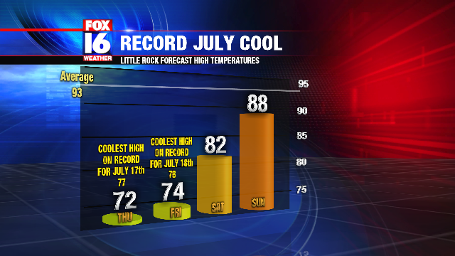
The wet weather is also keeping temperatures much below average for this time of year. It feels more like October rather than July with highs Thursday only in the 70s. Little Rock broke the record for the coolest high temperature on July 17th with a high of only 72. The previous record was 77. Another record low high temperature will likely be broken again for Friday as highs only reach the low 70s. The record low high for Friday in Little Rock is 78.
Temperatures will begin to get back normal by Sunday, with Summer heat returning by early next week.
No comments:
Post a Comment