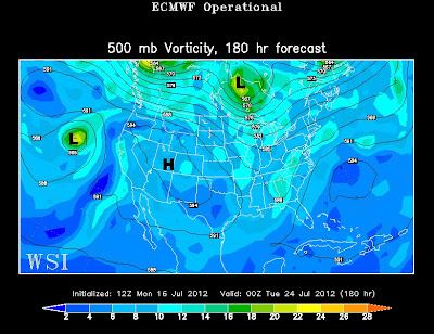
Our weather pattern is about to change...in a negative way. A ridge of high pressure is going to develop in the mid levels of our atmosphere and suffocate the Central Plains in the brutal triple digit heat. In other words, it's going to get real hot, real fast.
Arkansas will be heavily influenced by this high pressure system during the latter half of the work week with temperatures tip toeing near 100° with heat index values pushing for 105°-107°. Unfortunately, there will be no big rain shower or storm system to save us from this heat machine.
(European weather model showing the high pressure anchored over Utah on Monday evening)
If there any good news to be found in the weather department you have to look past this week. Next week the weather models suggest the high pressure system will shift westward allowing for a few small disturbances to march back into Arkansas. In theory this setup should provide more opportunities for rain and less chances of us baking under the summer sun - we'll see if that happens in the future.


No comments:
Post a Comment