Saturday, July 28, 2012

Dangerous Heat Coming

After a little relief from the heat, and I mean little, we're back on track to have dangerous heat sweep through the Natural State.

This Saturday is already a testament of just how bad it can get out there.  Little Rock topped out at a  record setting 107° - Yikes!


The sad part here is that the heat is going to be downright dangerous as we get into Monday. As we begin the work week, our surface winds are going to come out of the west/southwest.  Since an upper level ridge will already be in place, this wind setup will cause thermometers spike up to possibly 110°.  You read that right, 110°.

I hate to say it, but after Monday were going to stay in the triple digits in the next seven days. With all this in mind, just try to stay inside during the afternoon and stay hydrated as much as possible.


Heat Advisory

A heat advisory is in effect for much of Central Arkansas at least through Sunday evening. Temperatures over 100 this afternoon combined with moderate humidity will send heat index values well over 105, especially along the I-40 corridor.


High temperatures will range from 100 to 105 across Central Arkansas Saturday afternoon. Tonight will be clear and warm with lows in the upper 70s. More intense heat is on the way for Sunday with highs near 105. Brutal record heat continues into Monday with high temperatures 105 to 110. Try to avoid prolonged outdoor activity during the afternoon hours. If you must be outdoors, make sure to drink plenty of water even you don't feel thirsty. Take frequent breaks and stay out of direct sunlight if possible.

Sunday, July 22, 2012

Shot at Rain

Even though temperatures are going to creep back to the triple digits there is a glimmer of hope this week.


Recent data from our weather models reveal a weak cold front could manage to slide down here by the end of the work week.  If this scenario plays out like we want it to, then we could be looking at a decent chance at scattered showers and thunderstorms by Friday.

                               (European model showing rain chances coming back Arkansas Friday)

We've said time and time again that nothing is set in stone with Mother Nature but at least there is something to keep our mind busy besides focusing on the sweltering heat.

Monday, July 16, 2012

Hot Weather Returns

We've avoided the intense heat for a number of days now with the onset of scattered thunderstorms and cloud cover, but in the near future, we won't be so lucky in Arkansas.


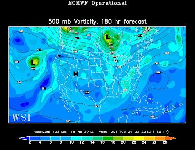
Our weather pattern is about to change...in a negative way.  A ridge of high pressure is going to develop in the mid levels of our atmosphere and suffocate the Central Plains in the brutal triple digit heat. In other words, it's going to get real hot, real fast.

Arkansas will be heavily influenced by this high pressure system during the latter half of the work week with temperatures tip toeing near 100° with heat index values pushing for 105°-107°.  Unfortunately, there will be no big rain shower or storm system to save us from this heat machine.

(European weather model showing the high pressure anchored over Utah on Monday evening) 
 

If there any good news to be found in the weather department you have to look past this week.  Next week the weather models suggest the high pressure system will shift westward allowing for a few small disturbances to march back into Arkansas.  In theory this setup should provide more opportunities for rain and less chances of us baking under the summer sun - we'll see if that happens in the future.

Thursday, July 12, 2012

Extreme Drought For Parts of Arkansas

Drought conditions continue to worsen for most of Arkansas with exceptional drought, the highest level of drought condition on the U.S. Drought Monitor, now showing up in parts of the State.


Much of Arkansas is now in severe drought, as indicated in red. Although there have been a few spotty showers around the last couple of days, it has done little in putting any dent in the drought situation. Rain chances will increase somewhat into the weekend, but coverage will be rather scattered. A widespread rainfall is needed in order to begin to bust the drought, which does not seem likely any time soon.

Sunday, July 8, 2012

Just What the Doctor Ordered

We've been hoping for rain to come back to the Natural State ever since grass fires and the brutal triple digit heat ran rampant across the region.  Today and tomorrow just might be what the doctor ordered.


On this Sunday, a tiny disturbance in the mid levels of the atmosphere will rotate in here from southeast and give us a great opportunity at rain, probably the best chance we've seen in weeks.  Thanks to the cloud cover and the rain cooled air we will not hit the triple digits in the viewing area.  In fact, temperatures may struggle just to make it to 90°.


The news gets better in the weather department. Tomorrow maybe an even better day for widespread rain and storms in the state.  During this time, a weak cold front is anticipated to slide through the state. The best part about all of this is that the frontal boundary won't be a quick mover.  The boundary will linger around here for several more days before washing out.  This setup will allow more opportunities for much needed rain drops.

By no means will this be a drought buster but certainly is what we have been asking for in Arkansas.  So hold off on watering the lawn and enjoy the sight while it last.