Thursday, July 31, 2014

Very Cool and Wet July

July 2014 will go down in the record books as a very cool and wet month. The average temperature for the month of July in Little Rock this July was only 77.5 degrees, over 5 degrees below average. This makes this July tied for the 3rd coolest on record.


This is also the coolest July in over a century. The top 2 coolest Julys are from 1905 and 1891! On of the reasons for the unusually cool temperatures was numerous days with lots of clouds and rain around. This is July was the wettest since 2009 in Little Rock and there was more rain this month than the last FOUR Julys combined. The total rainfall for the month fell just short of landing in the top 10 wettest list for July though, short by only a couple of tenths of an inch. 


7.19 inches of rain was recorded in Little Rock as of Thursday afternoon, which over twice as much as the average. August starts off a lot like July ended, with lots of clouds and temperatures that don't feel much like the middle of Summer. 

Tuesday, July 29, 2014

Unusually Cool and Wet

This Summer has certainly been an unusual one, with only a handful of very hot days so far. The temperature in Little Rock has only hit 95 degrees 3 times so far this Summer. For comparison, the temperature in Little Rock hit 95 degrees over 40 times by this time in the Summer in 2011! The cool trend continues as highs remain much below normal for the middle of this week. Clouds and showers will keep highs barely from getting to 80 on Wednesday, with highs likely staying in the 70s Thursday.


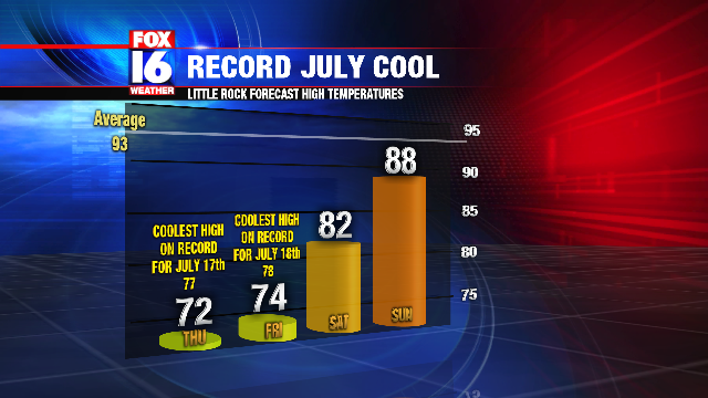
The record for the coolest high temperature Thursday is only 74, and if the clouds and showers hang on to the afternoon, the record may be broken for Little Rock. A slow warm up begins by the end of the week, but temperatures remain well below average.

Rain will approach by Wednesday afternoon with mainly just a few light showers, but a couple of isolated heavier showers are also possible. Strong storms are not expected. Most of the rain will move through overnight Wednesday into early Thursday.


Some showers will linger into Thursday afternoon, but lingering clouds will keep temperatures in the 70s.

Thursday, July 17, 2014

A Flash Flood Watch is in effect through Friday evening for parts of Arkansas including the Little Rock metro area. A disturbance moving along a front brings rain across the State tonight. Some of the rain will be heavy overnight with 1 to 2 inches of rain across much of Central Arkansas, and up to 3 inches South. Rainfall amounts will be less North of I-40. Due to the already rather saturated grounds from recent rainfall, the rains will create some spotty flooding problems, especially for Friday morning. Rain will begin to diminish by Friday afternoon. Some isolated thunder is possible in a few spots, but severe storms are not expected.


The wet weather is also keeping temperatures much below average for this time of year. It feels more like October rather than July with highs Thursday only in the 70s. Little Rock broke the record for the coolest high temperature on July 17th with a high of only 72. The previous record was 77. Another record low high temperature will likely be broken again for Friday as highs only reach the low 70s. The record low high for Friday in Little Rock is 78.


Temperatures will begin to get back normal by Sunday, with Summer heat returning by early next week.

Friday, July 26, 2013

Wet and Cool Friday

A wet and relatively cool mid-Summer afternoon across Central Arkansas Friday with widespread rain and much below normal high temperatures. A large area of rain is overspreading the State this afternoon and this evening, with little in the way of any thunder.


Most of the rain has been light, but a few areas of some heavier rain are still possible through tonight. A flash flood watch is in effect for much of the Western half the State through this evening.


Due to the mostly light and steady nature of the rainfall, any flooding problems should be very isolated. This is exactly the kind of rain we need to alleviate the dry conditions from the last few weeks.

The clouds and rain have kept temperatures quite cool for this time of year. High temperatures so far today have been mainly in the 70s.


The high in Little Rock so far Friday has only reached 77 degrees. This is the first time the high temperature in Little Rock failed to hit a daily high of at least 80 in July since 2009. The last time the high temperature in Little Rock did not hit 80 in July was July 20th 2009 with a high of 79. Normal highs this time of year are in the low to mid 90s.

Thursday, July 11, 2013

Drought Develops in Arkansas

Several weeks of dry conditions are leading to worsening drought across Arkansas. Even though a few spots have received some rainfall over the last couple of days, the isolated and brief nature of the rain has not been enough to alleviate the dry conditions. The U.S. Drought Monitor now shows parts of Arkansas under moderate drought, with dry conditions across much the State. The areas considered dry will go into drought conditions soon if no significant rain occurs.


Drought conditions are nowhere near as bad as they were this time last year. By mid- July of 2012, much of Arkansas was under severe to extreme drought.


Fire danger is quickly increasing due to the dry weather. Burn bans are now in effect for numerous Arkansas Counties.


(County Burn Bans as of 10PM Friday July 12th)

The outlook for any significant rain is slim going into next week, which will likely lead to worsening drought conditions and more burn bans.

Thursday, June 27, 2013

Temperatures in Central Arkansas reached the 100 degree mark for the first time this year so far in many spots. Little Rock National Airport recorded a temperature of 100 degrees at 3 PM with a heat index of 108.


Heat Index values across Central Arkansas are topping 110 in some spots, which can be dangerous if with prolonged outdoor exposure or strenuous activity.


Thunderstorms will become likely during the late evening and overnight hours as a disturbance approaches from the Northwest. Some storms may produce some strong gusty winds. Below is the forecast radar for around Midnight.


The Storm Prediction Center indicates a SLIGHT risk for severe storms through tonight in the area shaded in yellow.


Monday, May 20, 2013

Severe Weather Risk

TUESDAY IS A FOX16 SEVERE WEATHER ALERT DAY

A slow moving front moving into the State accompanied by a potent upper level disturbance will bring another round of strong to severe thunderstorms to parts of the State Tuesday.
Below are the current watches and warnings.


The front will move into Arkansas Tuesday as a wave of low pressure moves up along the front. This will trigger another round of storms by late Tuesday afternoon into Tuesday evening. Storms will begin to develop during the late afternoon hours.


The storms will initially pose a hail and tornado risk, transitioning into a more of a wind risk by later in the evening.


Storms may move over the same area through the late evening hours, with the threat for locally very heavy rain and flash flooding.

The Storm Prediction Center has issued a MODERATE Risk area for parts of Central Arkansas Tuesday.


The main severe weather risks will be gusty winds and hail. A tornado threat may also come into play, but this is still somewhat in question. Pay close attention to the weather tonight and tomorrow and be ready to heed any warnings that are issued.