A Severe Thunderstorm Watch has been issued for much of Northern Arkansas through late this afternoon. A line of thunderstorms is moving Southward through Missouri which will impact Northern Counties by about Noon. In addition, individual storms will develop ahead of this line, with a significant threat if large hail and some isolated wind gusts also possible.
The threat of storms for Central Arkansas will increase later this afternoon into the evening hours as storms begin to shift South. The Storm Prediction Center indicates a SLIGHT risk for severe storms for today with hail and wind the primary threats.
The tornado threat is overall low, however, a brief tornado cannot be completely ruled out with some of the stronger individual storms during the afternoon and early evening hours.
Monday, June 11, 2012
Sunday, June 10, 2012
Strong Storms on the Horizon
Well, the latest weather models are out and they all agree that Mother Nature could bring us a good dousing sometime early next week. Before you stop watering the lawn and washing the car, you might want to keep this thought in mind - besides the rain chances there will be a shot at some strong thunderstorms in Central Arkansas.
As a weak cold front struggles to move southward Monday afternoon, there will be an unstable air mass out ahead of it in Arkansas. If there is enough forcing present and daytime heating, we could see large hail and gusty winds develop. When it comes to a tornado threat it appears it is slim to none at this point with the lack of strong upper level winds.
The Storm Prediction Center has taken note of this setup and issued a slight risk of severe weather for Arkansas. If you're not familiar with slight risk outlook, it just means that well-organized severe thunderstorms are expected but in relatively small numbers/coverage.
No matter what SPC has to say about our weather, we'll continue to monitor the severe threats late Monday. Be sure to keep it tuned to FOX 16 News for the latest on this developing story.
Thursday, June 7, 2012
Drought Conditions worsening in Arkansas
The recent dry weather is beginning to take its toll on Arkansas with drought conditions spreading throughout the State. As of May 25th, most of Arkansas was considered "dry" with Northeast Arkansas in moderate drought according to The U.S. Drought Monitor, which tracks drought conditions across the United States.
The latest drought monitor analysis released the week of June 7th now shows most of Arkansas in the moderate drought category
Rain chances will go up for the early part of next week, however rain coverage is likely to be quite isolated. The seasonal drought outlook released by NOAA (National Oceanic and Atmospheric Administration) indicates drought conditions across most of Arkansas will either persist or get worse through the Summer season.
The latest drought monitor analysis released the week of June 7th now shows most of Arkansas in the moderate drought category
Rain chances will go up for the early part of next week, however rain coverage is likely to be quite isolated. The seasonal drought outlook released by NOAA (National Oceanic and Atmospheric Administration) indicates drought conditions across most of Arkansas will either persist or get worse through the Summer season.
Tuesday, June 5, 2012
Landspout Tornado in Lonoke County
A brief landspout type tornado touched down in Lonoke County Monday afternoon according to The National Weather Service in Little Rock. This was not a classic tornado produced by a rotating thunderstorm, but rather a landspout which is basically a waterspout over land. A landspout sometimes forms underneath a rapidly growing towering cumulus cloud away from thunderstorms on very warm and humid days. They typically form during the Summer months and are very weak and short lived compared to ordinary tornadoes. Below is a picture of the funnel taken by a storm Chaser in Lonoke County Monday afternoon.
The storm chaser noted to the weather service that there was no thunder at the time. According to The Weather Service, there was no storm showing any signs of rotation in the area, which is why there was no warning issued. Below is a map showing the estimated location of the landspout tornado.
According to John Robinson of The National Weather Service in Little Rock, the landspout touched down roughly 7 miles South-Southwest of Carlisle in Lonoke County near Arkansas Highway 13. There was no damage or even much in the way of any physical evidence of a tornado touchdown associated with the landspout. Given the lack of any discernible damage, the landspout is classified as an EF0 tornado with no real path length or width. An EF0 is the weakest classification of a torando with winds less than 85 MPH. The Weather Service used pictures to determine that the funnel briefly touched down. The landspout still counts as a tornado though, which brings the Arkansas 2012 tornado count to 11.
The storm chaser noted to the weather service that there was no thunder at the time. According to The Weather Service, there was no storm showing any signs of rotation in the area, which is why there was no warning issued. Below is a map showing the estimated location of the landspout tornado.
According to John Robinson of The National Weather Service in Little Rock, the landspout touched down roughly 7 miles South-Southwest of Carlisle in Lonoke County near Arkansas Highway 13. There was no damage or even much in the way of any physical evidence of a tornado touchdown associated with the landspout. Given the lack of any discernible damage, the landspout is classified as an EF0 tornado with no real path length or width. An EF0 is the weakest classification of a torando with winds less than 85 MPH. The Weather Service used pictures to determine that the funnel briefly touched down. The landspout still counts as a tornado though, which brings the Arkansas 2012 tornado count to 11.
Viewing the Transit of Venus
Astronomy enthusiasts will get a glimpse of a very rare sight this evening. The planet Venus will run its course and position itself in front of our Sun to where we are suppose to see it on Earth. Known as the "transit of Venus", this twice in a generation viewing happens every 105.5 and 121.5 years. We saw our last transit of Venus in 2004, so this means today's sighting will be the last one until December 2117.
The question is will we see it in Arkansas?
If the transit of Venus were to occur this Tuesday afternoon we might have a hard time looking for it with all of the cumulus clouds around. However, looking ahead in the future the cloud cover will be less and the sky should be clear enough to see the transit this evening.
According to NASA, the transit of Venus will begin at 5:09 P.M. and will go on until the sun sets over the horizon at 8:19 P.M.
If you plan on trying to take a snapshot of it with your camera just be aware that you have to careful with your eyes - they could be damaged by looking at the sun for a length of time. The safest way to view the transit is to construct a so-called pinhole camera.
The question is will we see it in Arkansas?
If the transit of Venus were to occur this Tuesday afternoon we might have a hard time looking for it with all of the cumulus clouds around. However, looking ahead in the future the cloud cover will be less and the sky should be clear enough to see the transit this evening.
According to NASA, the transit of Venus will begin at 5:09 P.M. and will go on until the sun sets over the horizon at 8:19 P.M.
If you plan on trying to take a snapshot of it with your camera just be aware that you have to careful with your eyes - they could be damaged by looking at the sun for a length of time. The safest way to view the transit is to construct a so-called pinhole camera.
Monday, June 4, 2012
Some storms, much needed rainfall
Update:
The National Weather Service in Little Rock has reported that landspout tornado may have briefly touched down Monday afternoon in Lonoke County between Humnoke and Carlisle along Highway 13. The picture below shows the funnel, but does not show it touching the ground.
A landspout does not originate from a super-cell thunderstorm as does a regular tornado. These usually form underneath towering cumulus clouds under the right conditions away from thunderstorms. It is actually caused by the same process that causes a waterspout, but forms over land. Landspouts are usually much weaker than regular tornadoes and do not last very long. No damage was reported. The landspout does count as a tornado, and brings the total tornado count for Arkansas for the year up to 11.
A round of storms Monday afternoon brought much needed rainfall to Central Arkansas, with a few reports of severe weather. Storms were not as strong as Sunday, but some spots were hit by hail and some strong wind gusts. Below is a map of storm reports Monday followed by the descriptions of the reports.
PRELIMINARY LOCAL STORM REPORT...SUMMARY
NATIONAL WEATHER SERVICE LITTLE ROCK AR
708 PM CDT MON JUN 04 2012
..TIME... ...EVENT... ...CITY LOCATION... ...LAT.LON...
..DATE... ....MAG.... ..COUNTY LOCATION..ST.. ...SOURCE....
..REMARKS..
0125 PM TSTM WND DMG 2 E WILLIAMS JUNCTION 34.88N 92.74W
06/04/2012 PULASKI AR PUBLIC
THUNDERSTORM WINDS BROKE OFF THE TOPS OF SEVERAL OAK
TREES AT THE PERRY/PULASKI COUNTY LINE.
0340 PM HEAVY RAIN 1 ENE NORTH LITTLE ROCK 34.79N 92.24W
06/04/2012 M1.50 INCH PULASKI AR AMATEUR RADIO
AMATEUR RADIO REPORTED 1.50 INCHES OF RAIN IN 30 MINUTES.
0342 PM HAIL 3 N LEOLA 34.21N 92.59W
06/04/2012 E1.00 INCH GRANT AR PUBLIC
MEMBER OF PUBLIC CALLED AND REPORTED HAIL APPROXIMATELY
THE SIZE OF QUARTERS.
0344 PM HAIL POYEN 34.32N 92.64W
06/04/2012 E1.00 INCH GRANT AR PUBLIC
0355 PM HEAVY RAIN 2 N NORTH LITTLE ROCK 34.82N 92.26W
06/04/2012 M1.15 INCH PULASKI AR OFFICIAL NWS OBS
BETWEEN 300 PM AND 355 PM CDT 1.15 INCHES OF RAIN FELL AT
THE NWS OFFICE IN NORTH LITTLE ROCK.
0426 PM TSTM WND DMG 1 N GRAPEVINE 34.16N 92.32W
06/04/2012 GRANT AR LAW ENFORCEMENT
TREES ARE DOWN ALONG COUNTY ROAD 16 NORTH OF GRAPEVINE.
0508 PM TSTM WND DMG RISON 33.95N 92.19W
06/04/2012 CLEVELAND AR LAW ENFORCEMENT
MANY POWER LINES ARE DOWN ACROSS RISON LEAVING MANY
PEOPLE WITHOUT POWER.
0529 PM HAIL 2 W IVAN 33.90N 92.47W
06/04/2012 E1.00 INCH DALLAS AR TRAINED SPOTTER
The storms did bring much needed rainfall to many parts of the State over the last couple of days. Below is a map of rainfall amounts around the State since Sunday morning.
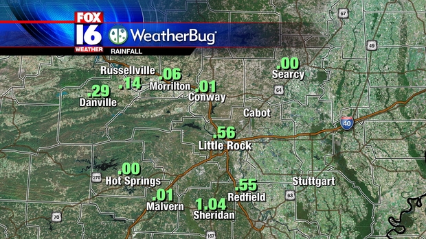
North Little Rock broke its daily rainfall record for the day with 1.36". 1.15" of that rainfall fell in a single hour. Our FOX16 Weatherbug stations across Central Arkansas also reported some decent rainfall totals in a few spots Monday.
The wetter pattern will not last as drier air moves in for the middle of the week behind a weak front. Rain chances will drop to around zero for the rest of the week with afternoon showers not returning until early next week.
The National Weather Service in Little Rock has reported that landspout tornado may have briefly touched down Monday afternoon in Lonoke County between Humnoke and Carlisle along Highway 13. The picture below shows the funnel, but does not show it touching the ground.
A landspout does not originate from a super-cell thunderstorm as does a regular tornado. These usually form underneath towering cumulus clouds under the right conditions away from thunderstorms. It is actually caused by the same process that causes a waterspout, but forms over land. Landspouts are usually much weaker than regular tornadoes and do not last very long. No damage was reported. The landspout does count as a tornado, and brings the total tornado count for Arkansas for the year up to 11.
A round of storms Monday afternoon brought much needed rainfall to Central Arkansas, with a few reports of severe weather. Storms were not as strong as Sunday, but some spots were hit by hail and some strong wind gusts. Below is a map of storm reports Monday followed by the descriptions of the reports.
PRELIMINARY LOCAL STORM REPORT...SUMMARY
NATIONAL WEATHER SERVICE LITTLE ROCK AR
708 PM CDT MON JUN 04 2012
..TIME... ...EVENT... ...CITY LOCATION... ...LAT.LON...
..DATE... ....MAG.... ..COUNTY LOCATION..ST.. ...SOURCE....
..REMARKS..
0125 PM TSTM WND DMG 2 E WILLIAMS JUNCTION 34.88N 92.74W
06/04/2012 PULASKI AR PUBLIC
THUNDERSTORM WINDS BROKE OFF THE TOPS OF SEVERAL OAK
TREES AT THE PERRY/PULASKI COUNTY LINE.
0340 PM HEAVY RAIN 1 ENE NORTH LITTLE ROCK 34.79N 92.24W
06/04/2012 M1.50 INCH PULASKI AR AMATEUR RADIO
AMATEUR RADIO REPORTED 1.50 INCHES OF RAIN IN 30 MINUTES.
0342 PM HAIL 3 N LEOLA 34.21N 92.59W
06/04/2012 E1.00 INCH GRANT AR PUBLIC
MEMBER OF PUBLIC CALLED AND REPORTED HAIL APPROXIMATELY
THE SIZE OF QUARTERS.
0344 PM HAIL POYEN 34.32N 92.64W
06/04/2012 E1.00 INCH GRANT AR PUBLIC
0355 PM HEAVY RAIN 2 N NORTH LITTLE ROCK 34.82N 92.26W
06/04/2012 M1.15 INCH PULASKI AR OFFICIAL NWS OBS
BETWEEN 300 PM AND 355 PM CDT 1.15 INCHES OF RAIN FELL AT
THE NWS OFFICE IN NORTH LITTLE ROCK.
0426 PM TSTM WND DMG 1 N GRAPEVINE 34.16N 92.32W
06/04/2012 GRANT AR LAW ENFORCEMENT
TREES ARE DOWN ALONG COUNTY ROAD 16 NORTH OF GRAPEVINE.
0508 PM TSTM WND DMG RISON 33.95N 92.19W
06/04/2012 CLEVELAND AR LAW ENFORCEMENT
MANY POWER LINES ARE DOWN ACROSS RISON LEAVING MANY
PEOPLE WITHOUT POWER.
0529 PM HAIL 2 W IVAN 33.90N 92.47W
06/04/2012 E1.00 INCH DALLAS AR TRAINED SPOTTER
The storms did bring much needed rainfall to many parts of the State over the last couple of days. Below is a map of rainfall amounts around the State since Sunday morning.
North Little Rock broke its daily rainfall record for the day with 1.36". 1.15" of that rainfall fell in a single hour. Our FOX16 Weatherbug stations across Central Arkansas also reported some decent rainfall totals in a few spots Monday.
The wetter pattern will not last as drier air moves in for the middle of the week behind a weak front. Rain chances will drop to around zero for the rest of the week with afternoon showers not returning until early next week.
Numerous thunderstorms brought hail and some strong wind gusts to the Northern half of Arkansas Sunday. No major damage was reported, but some large tree limbs were brought down and hail was larger than Golf Ball size in a couple of locations. Below is a map of the damage reports from Sunday.
One of the hardest hit places Sunday was the town of Shirley in Van Buren County, where strong winds brought down numerous trees and caused some damage. The National Weather Service determined straight line winds of 75 MPH were responsible. Below is a complete list of severe weather reports from Sunday June 3rd.
PRELIMINARY LOCAL STORM REPORT...SUMMARY
NATIONAL WEATHER SERVICE LITTLE ROCK AR
719 PM CDT MON JUN 04 2012
..TIME... ...EVENT... ...CITY LOCATION... ...LAT.LON...
..DATE... ....MAG.... ..COUNTY LOCATION..ST.. ...SOURCE....
..REMARKS..
0434 PM HAIL 5 NNE COMPTON 36.15N 93.28W
06/03/2012 E1.00 INCH BOONE AR PUBLIC
0522 PM TSTM WND GST VENDOR 35.95N 93.08W
06/03/2012 M59.00 MPH NEWTON AR TRAINED SPOTTER
A 59 MPH GUST WAS MEASURED AT VENDOR.
0522 PM TSTM WND DMG PIERCETOWN 35.97N 93.07W
06/03/2012 NEWTON AR TRAINED SPOTTER
TREES REPORTED DOWN.
0526 PM HAIL OLYPHANT 35.52N 91.38W
06/03/2012 E1.75 INCH JACKSON AR LAW ENFORCEMENT
0616 PM HAIL OIL TROUGH 35.63N 91.46W
06/03/2012 E0.75 INCH INDEPENDENCE AR TRAINED SPOTTER
0620 PM HAIL 3 ENE BOTKINBURG 35.72N 92.47W
06/03/2012 M1.75 INCH VAN BUREN AR TRAINED SPOTTER
CORRECTION TO THE REPORT OF GOLF BALL SIZE HAIL 3ENE OF
DENNARD. SPOTTER WAS 3ENE OF BOTKINBURG.
0620 PM TSTM WND DMG CLINTON 35.58N 92.45W
06/03/2012 VAN BUREN AR TRAINED SPOTTER
TREES WERE DOWNED IN CLINTON.
0620 PM HAIL DENNARD 35.75N 92.52W
06/03/2012 E1.50 INCH VAN BUREN AR TRAINED SPOTTER
0627 PM TSTM WND DMG SHIRLEY 35.64N 92.31W
06/03/2012 VAN BUREN AR LAW ENFORCEMENT
SEVERAL TREES AND POWERLINES DOWNED WITH REPORTS OF ROOF
DAMAGE.
0627 PM TSTM WND DMG SHIRLEY 35.64N 92.31W
06/03/2012 VAN BUREN AR NWS STORM SURVEY
THOUSANDS OF TREES WERE SNAPPED OFF, UPROOTED, AND/OR
BLOWN DOWN WITHIN A SEVEN MILE RADIUS OF SHIRLEY. SEVERAL
TREES FELL ON HOUSES. SHINGLES WERE TAKEN OFF ROOFS AND
METAL OFF OF BARNS. OUTBUILDINGS WERE DAMAGED AND A
VEHICLE WAS TRAPPED BY FALLEN POWERLINES. NO INJURIES
WERE REPORTED. WINDS WERE ESTIMATED AT 75 MPH. A SPECIAL
THANKS GOES OUT TO COUNTY JUDGE ROGER HOOPER FOR HIS
ASSISTANCE WITH THIS NWS STORM SURVEY.
0633 PM HAIL OARK 35.68N 93.58W
06/03/2012 E1.00 INCH JOHNSON AR LAW ENFORCEMENT
0635 PM TSTM WND DMG 6 N CLINTON 35.67N 92.45W
06/03/2012 VAN BUREN AR AWOS
A WIND GUST OF 53 MPH WAS MEASURED AT THE CLINTON
AIRPORT.
0644 PM TSTM WND DMG 3 SE HARMONY 35.52N 93.53W
06/03/2012 JOHNSON AR LAW ENFORCEMENT
WINDS EST. AT 60 MPH. TREES AND STRUCTURE DAMAGE
REPORTED. ALSO PEA SIZE HAIL.
0645 PM TSTM WND DMG 2 E FAIRFIELD BAY 35.61N 92.23W
06/03/2012 CLEBURNE AR PUBLIC
TREES WERE DOWN IN THE GREERS FERRY LAKE AREA. A TREE
LIMB FELL ON TO A POWER LINE. TREES WERE BLOWN DOWN IN
THE DEVILS FORK RECREATION AREA.
0655 PM HAIL HICKORY FLAT 35.48N 91.75W
06/03/2012 E2.50 INCH WHITE AR PUBLIC
0656 PM TSTM WND DMG COTTER 36.28N 92.52W
06/03/2012 BAXTER AR BROADCAST MEDIA
TREES WERE BLOWN DOWN.
0715 PM TSTM WND GST 3 S BATESVILLE 35.72N 91.62W
06/03/2012 M48.00 MPH INDEPENDENCE AR AWOS
0720 PM TSTM WND DMG BATESVILLE 35.77N 91.62W
06/03/2012 INDEPENDENCE AR LAW ENFORCEMENT
NUMEROUS TREES AND POWER LINES WERE BLOWN DOWN...SOME
TREES FELL ON HOUSES. ALSO THERE WERE SOME FIRES STARTED
BY LIGHTNING.
0724 PM HAIL LONDON 35.33N 93.25W
06/03/2012 E0.88 INCH POPE AR TRAINED SPOTTER
0724 PM TSTM WND DMG LONDON 35.33N 93.25W
06/03/2012 POPE AR TRAINED SPOTTER
TREES WERE BLOWN DOWN.
0737 PM HAIL RUSSELLVILLE 35.27N 93.14W
06/03/2012 E1.00 INCH POPE AR TRAINED SPOTTER
0747 PM TSTM WND GST 3 SE OIL TROUGH 35.60N 91.42W
06/03/2012 M61.00 MPH INDEPENDENCE AR TRAINED SPOTTER
0754 PM TSTM WND DMG POTTSVILLE 35.24N 93.06W
06/03/2012 POPE AR TRAINED SPOTTER
MULTIPLE TREE LIMBS ARE DOWN WITH SOME DAMAGE TO A ROOF.
0840 PM HAIL OPPELO 35.10N 92.78W
06/03/2012 E0.88 INCH CONWAY AR TRAINED SPOTTER
0855 PM HAIL BIGELOW 35.00N 92.63W
06/03/2012 E1.00 INCH PERRY AR PUBLIC
0910 PM TSTM WND DMG 2 W MAYFLOWER 34.97N 92.46W
06/03/2012 FAULKNER AR TRAINED SPOTTER
TREE DOWN ON WINTER CREEK ROAD NEAR HWY 89 WEST OF
MAYFLOWER
1235 AM HAIL MOUNTAIN HOME 36.34N 92.38W
06/04/2012 E0.88 INCH BAXTER AR PUBLIC
1240 AM HAIL MOUNTAIN HOME 36.34N 92.38W
06/04/2012 E1.25 INCH BAXTER AR LAW ENFORCEMENT
1243 AM HAIL MOUNTAIN HOME 36.34N 92.38W
06/04/2012 E1.75 INCH BAXTER AR PUBLIC
A couple of tornado reports in Northeast Arkansas were relayed to NWS Memphis, but no tornadoes have been confirmed as of Monday Evening.
One of the hardest hit places Sunday was the town of Shirley in Van Buren County, where strong winds brought down numerous trees and caused some damage. The National Weather Service determined straight line winds of 75 MPH were responsible. Below is a complete list of severe weather reports from Sunday June 3rd.
PRELIMINARY LOCAL STORM REPORT...SUMMARY
NATIONAL WEATHER SERVICE LITTLE ROCK AR
719 PM CDT MON JUN 04 2012
..TIME... ...EVENT... ...CITY LOCATION... ...LAT.LON...
..DATE... ....MAG.... ..COUNTY LOCATION..ST.. ...SOURCE....
..REMARKS..
0434 PM HAIL 5 NNE COMPTON 36.15N 93.28W
06/03/2012 E1.00 INCH BOONE AR PUBLIC
0522 PM TSTM WND GST VENDOR 35.95N 93.08W
06/03/2012 M59.00 MPH NEWTON AR TRAINED SPOTTER
A 59 MPH GUST WAS MEASURED AT VENDOR.
0522 PM TSTM WND DMG PIERCETOWN 35.97N 93.07W
06/03/2012 NEWTON AR TRAINED SPOTTER
TREES REPORTED DOWN.
0526 PM HAIL OLYPHANT 35.52N 91.38W
06/03/2012 E1.75 INCH JACKSON AR LAW ENFORCEMENT
0616 PM HAIL OIL TROUGH 35.63N 91.46W
06/03/2012 E0.75 INCH INDEPENDENCE AR TRAINED SPOTTER
0620 PM HAIL 3 ENE BOTKINBURG 35.72N 92.47W
06/03/2012 M1.75 INCH VAN BUREN AR TRAINED SPOTTER
CORRECTION TO THE REPORT OF GOLF BALL SIZE HAIL 3ENE OF
DENNARD. SPOTTER WAS 3ENE OF BOTKINBURG.
0620 PM TSTM WND DMG CLINTON 35.58N 92.45W
06/03/2012 VAN BUREN AR TRAINED SPOTTER
TREES WERE DOWNED IN CLINTON.
0620 PM HAIL DENNARD 35.75N 92.52W
06/03/2012 E1.50 INCH VAN BUREN AR TRAINED SPOTTER
0627 PM TSTM WND DMG SHIRLEY 35.64N 92.31W
06/03/2012 VAN BUREN AR LAW ENFORCEMENT
SEVERAL TREES AND POWERLINES DOWNED WITH REPORTS OF ROOF
DAMAGE.
0627 PM TSTM WND DMG SHIRLEY 35.64N 92.31W
06/03/2012 VAN BUREN AR NWS STORM SURVEY
THOUSANDS OF TREES WERE SNAPPED OFF, UPROOTED, AND/OR
BLOWN DOWN WITHIN A SEVEN MILE RADIUS OF SHIRLEY. SEVERAL
TREES FELL ON HOUSES. SHINGLES WERE TAKEN OFF ROOFS AND
METAL OFF OF BARNS. OUTBUILDINGS WERE DAMAGED AND A
VEHICLE WAS TRAPPED BY FALLEN POWERLINES. NO INJURIES
WERE REPORTED. WINDS WERE ESTIMATED AT 75 MPH. A SPECIAL
THANKS GOES OUT TO COUNTY JUDGE ROGER HOOPER FOR HIS
ASSISTANCE WITH THIS NWS STORM SURVEY.
0633 PM HAIL OARK 35.68N 93.58W
06/03/2012 E1.00 INCH JOHNSON AR LAW ENFORCEMENT
0635 PM TSTM WND DMG 6 N CLINTON 35.67N 92.45W
06/03/2012 VAN BUREN AR AWOS
A WIND GUST OF 53 MPH WAS MEASURED AT THE CLINTON
AIRPORT.
0644 PM TSTM WND DMG 3 SE HARMONY 35.52N 93.53W
06/03/2012 JOHNSON AR LAW ENFORCEMENT
WINDS EST. AT 60 MPH. TREES AND STRUCTURE DAMAGE
REPORTED. ALSO PEA SIZE HAIL.
0645 PM TSTM WND DMG 2 E FAIRFIELD BAY 35.61N 92.23W
06/03/2012 CLEBURNE AR PUBLIC
TREES WERE DOWN IN THE GREERS FERRY LAKE AREA. A TREE
LIMB FELL ON TO A POWER LINE. TREES WERE BLOWN DOWN IN
THE DEVILS FORK RECREATION AREA.
0655 PM HAIL HICKORY FLAT 35.48N 91.75W
06/03/2012 E2.50 INCH WHITE AR PUBLIC
0656 PM TSTM WND DMG COTTER 36.28N 92.52W
06/03/2012 BAXTER AR BROADCAST MEDIA
TREES WERE BLOWN DOWN.
0715 PM TSTM WND GST 3 S BATESVILLE 35.72N 91.62W
06/03/2012 M48.00 MPH INDEPENDENCE AR AWOS
0720 PM TSTM WND DMG BATESVILLE 35.77N 91.62W
06/03/2012 INDEPENDENCE AR LAW ENFORCEMENT
NUMEROUS TREES AND POWER LINES WERE BLOWN DOWN...SOME
TREES FELL ON HOUSES. ALSO THERE WERE SOME FIRES STARTED
BY LIGHTNING.
0724 PM HAIL LONDON 35.33N 93.25W
06/03/2012 E0.88 INCH POPE AR TRAINED SPOTTER
0724 PM TSTM WND DMG LONDON 35.33N 93.25W
06/03/2012 POPE AR TRAINED SPOTTER
TREES WERE BLOWN DOWN.
0737 PM HAIL RUSSELLVILLE 35.27N 93.14W
06/03/2012 E1.00 INCH POPE AR TRAINED SPOTTER
0747 PM TSTM WND GST 3 SE OIL TROUGH 35.60N 91.42W
06/03/2012 M61.00 MPH INDEPENDENCE AR TRAINED SPOTTER
0754 PM TSTM WND DMG POTTSVILLE 35.24N 93.06W
06/03/2012 POPE AR TRAINED SPOTTER
MULTIPLE TREE LIMBS ARE DOWN WITH SOME DAMAGE TO A ROOF.
0840 PM HAIL OPPELO 35.10N 92.78W
06/03/2012 E0.88 INCH CONWAY AR TRAINED SPOTTER
0855 PM HAIL BIGELOW 35.00N 92.63W
06/03/2012 E1.00 INCH PERRY AR PUBLIC
0910 PM TSTM WND DMG 2 W MAYFLOWER 34.97N 92.46W
06/03/2012 FAULKNER AR TRAINED SPOTTER
TREE DOWN ON WINTER CREEK ROAD NEAR HWY 89 WEST OF
MAYFLOWER
1235 AM HAIL MOUNTAIN HOME 36.34N 92.38W
06/04/2012 E0.88 INCH BAXTER AR PUBLIC
1240 AM HAIL MOUNTAIN HOME 36.34N 92.38W
06/04/2012 E1.25 INCH BAXTER AR LAW ENFORCEMENT
1243 AM HAIL MOUNTAIN HOME 36.34N 92.38W
06/04/2012 E1.75 INCH BAXTER AR PUBLIC
A couple of tornado reports in Northeast Arkansas were relayed to NWS Memphis, but no tornadoes have been confirmed as of Monday Evening.
Subscribe to:
Posts (Atom)