Wednesday, May 30, 2012

Cold Front, Few Storms


A cold front will sweep into Arkansas Thursday with a few showers and thunderstorms likely. Most of the showers will be somewhat ahead of the front, moving through during the late morning into the early afternoon.


A few of the storms may be strong with isolated hail and some gusty winds the main threat. Below is the severe outlook from the Storm Prediction Center, showing a SLIGHT risk for parts of Arkansas.


Most showers and storms will push into Eastern and Southeast Arkansas during the late afternoon and exit the State by later in the evening.
Cooler, less humid air follows the front for the end of the week. Friday will be considerably cooler and less humid with highs in the 70s.


Low temperatures Saturday morning will even dip into the 50s, but the cool air won't stick around for long. Highs return to the 90s by early next week.

Tuesday, May 29, 2012

Thursday Cold Front

Rain chances are going up over the next couple of days thanks to an approaching cold front. Most of Arkansas could use a good drink of water after a very dry and hot May. The front will also bring a few storms, some of which could be potentially strong.

A few isolated showers and thunderstorms are likely on Wednesday, but rain coverage will increase Wednesday night and Thursday. Storms will quickly develop and intensify over Oklahoma Wednesday evening and push Eastward into Western Arkansas by late Wednesday night into Thursday morning.


The storms may initially be strong to severe as they move into Arkansas, however, the storms will tend to weaken as they push toward Central Arkansas later Thursday morning. The Storm Prediction Center indicates a SLIGHT risk for severe storm mainly for Western Arkansas for Wednesday into Wednesday night. Another round of severe weather is likely for Central Oklahoma, which was hard hit Tuesday night, where a MODERATE risk is indicated by The Storm Prediction Center.


An area of low pressure moving along a frontal boundary to our North will push the cold front into Arkansas by Thursday afternoon, likely igniting another round of storms.


Storms Thursday afternoon will pose the highest risk of producing severe weather, with hail and wind gusts the main threat. The Storm Prediction Center indicates a SLIGHT risk for severe storms for parts of Central, Eastern and Southern Arkansas Thursday.


Cooler, less humid air follows the front for the end of the week. Friday will be considerably cooler and less humid with highs in the 70s.


Low temperatures Saturday morning will even dip into the 50s, but the cool air won't stick around for long. Highs return to the 90s by early next week.

Record Hot Tuesday


Numerous temperature records fell across Arkansas on Tuesday as highs topped out in the upper 90s. Little broke the record high for the day hitting 97, North Little Rock reached 96, and Jacksonville topped out at 98. The hot spot for the State was Mena at 99 degrees. The weather service did note an observation of 100, but it was not an official reading. Below is the wrap up from The National Weather Service in Little Rock of Tuesday's heat:

PUBLIC INFORMATION STATEMENT
NATIONAL WEATHER SERVICE LITTLE ROCK AR
808 PM CDT TUE MAY 29 2012

...HOT TEMPERATURES TODAY IN ARKANSAS...

TEMPERATURES APPROACHED THE CENTURY MARK IN MUCH OF CENTRAL AND
SOUTHERN ARKANSAS THIS AFTERNOON. THE FOLLOWING IS A LIST OF SOME
HIGH TEMPERATURES FROM AROUND THE REGION FOR TODAY...


MENA AIRPORT                   99
ARKADELPHIA AIRPORT            98
JACKSONVILLE/LITTLE ROCK AFB   98
RUSSELLVILLE                   98
BATESVILLE AIRPORT             97
CLINTON AIRPORT                97
HOT SPRINGS AIRPORT            97
LITTLE ROCK ADAMS FIELD        97
SEARCY                         97
STUTTGART AIRPORT              97
MOUNT IDA                      96
NORTH LITTLE ROCK              96
CAMDEN AIRPORT                 95
MONTICELLO                     95
PINE BLUFF                     94

SEVERAL LOCATIONS SET RECORD TEMPERATURES...INCLUDING...

BATESVILLE AIRPORT...

AT BATESVILLE AIRPORT...THE HIGH TEMPERATURE OF 97 BROKE THE
PREVIOUS DAILY RECORD OF 94...WHICH WAS SET IN 1945. THIS IS ALSO
THE HOTTEST MAY TEMPERATURE ON RECORD AT THE BATESVILLE AIRPORT...
AND THIS TEMPERATURE WAS ALSO RECORDED ON MAY 28TH. THE PREVIOUS
HIGHEST RECORD TEMPERATURE FOR MAY WAS 96 DEGREES...WHICH WAS
RECORDED ON MAY 31ST 1937.

RECORDS FOR BATESVILLE AIRPORT BEGAN MARCH 1ST 1937.

MOUNT IDA...

AT MOUNT IDA...THE HIGH TEMPERATURE OF 96 BROKE THE PREVIOUS DAILY
RECORD OF 93...WHICH WAS SET IN 1925. THIS WAS THE SECOND HIGHEST
TEMPERATURE ON RECORD IN THE MONTH OF MAY AT MOUNT IDA. THIS
TEMPERATURE WAS LAST RECORDED ON MAY 31ST 1977. THE HIGHEST
TEMPERATURE IN THE MONTH OF MAY WAS 97 DEGREES...WHICH OCCURRED ON
MAY 30TH AND 31ST 1934.

RECORDS FOR MOUNT IDA BEGAN FEBRUARY 1ST 1872.

LITTLE ROCK ADAMS FIELD...

AT LITTLE ROCK ADAMS FIELD...THE HIGH WAS 97...AND BROKE THE
PREVIOUS RECORD OF 96 DEGREES...WHICH WAS SET IN 1926 AND AGAIN IN
1953. THIS ALSO IS THE SECOND HOTTEST TEMPERATURE EVER RECORDED IN
THE MONTH OF MAY AT LITTLE ROCK. THIS SAME TEMPERATURE WAS REACHED
ON MAY 31ST 1934...AND AGAIN ON MAY 30TH 1977.

THE HOTTEST TEMPERATURE ON RECORD IN THE MONTH OF MAY AT LITTLE ROCK
WAS 98 DEGREES. THIS OCCURRED ON MAY 26TH 1964...AND MOST RECENTLY
ON MAY 31ST 1998.

TEMPERATURE RECORDS FOR LITTLE ROCK BEGAN JULY 1ST 1879.

NORTH LITTLE ROCK...

AT NORTH LITTLE ROCK...THE HIGH WAS 96 DEGREES. THIS BROKE THE
PREVIOUS RECORD OF 94...WHICH WAS SET IN 1977.

THIS WAS ALSO THE THIRD HOTTEST TEMPERATURE ON RECORD IN THE MONTH
OF MAY...AND THE HOTTEST SINCE 97 DEGREES WAS RECORDED ON MAY 31ST
1998. THE HOTTEST MAY TEMPERATURE ON RECORD WAS 98 DEGREES...ON MAY
30TH 1977.

TEMPERATURE RECORDS FOR NORTH LITTLE ROCK BEGAN DECEMBER 31ST 1975.

JACKSONVILLE/LITTLE ROCK AFB...

A RECORD HIGH TEMPERATURE OF 98 DEGREES WAS SET AT JACKSONVILLE/
LITTLE ROCK AFB TODAY. THIS BROKE THE OLD RECORD OF 94...WHICH WAS
SET IN 1977.

THIS WAS THE THIRD HOTTEST TEMPERATURE ON RECORD IN THE MONTH OF MAY
AT JACKSONVILLE/LITTLE ROCK AFB.

THE HOTTEST MAY TEMPERATURE ON RECORD WAS 102 DEGREES...SET ON MAY
31ST 1998.

RECORDS FOR JACKSONVILLE/LITTLE ROCK AFB BEGAN JANUARY 1ST 1956.

HOT SPRINGS AIRPORT...

AT THE HOT SPRINGS AIRPORT...THE HIGH TEMPERATURE OF 97 BROKE THE
PREVIOUS DAILY RECORD HIGH OF 93...WHICH WAS SET IN 2000.

THIS WAS THE SECOND HOTTEST MAY TEMPERATURE RECORDED AT THE HOT
SPRINGS AIRPORT. THE HOTTEST TEMPERATURE WAS 98 DEGREES...ON MAY
31ST 1998...AND ON MAY 20TH 2005.

TEMPERATURE RECORDS FOR THE HOT SPRINGS AIRPORT BEGAN JANUARY 9TH
1948.

RUSSELLVILLE...

AT RUSSELLVILLE...THE HIGH OF 98 BROKE THE PREVIOUS RECORD OF 96
DEGREES...WHICH WAS SET IN 1998. THIS WAS THE HOTTEST MAY
TEMPERATURE AT RUSSELLVILLE SINCE LATE MAY 1951...AND THE SECOND
HOTTEST TEMPERATURE ON RECORD IN THE MONTH OF MAY. THE HOTTEST MAY
TEMPERATURE ON RECORD WAS 99 DEGREES...ON MAY 31ST 1886.

RECORDS FOR RUSSELLVILLE BEGAN MAY 1ST 1882.

ALSO...THE TEMPERATURE REACHED 100 DEGREES ON PETIT JEAN MOUNTAIN
THIS AFTERNOON...

ASTRONOMER CLAY SHERROD REPORTED THAT THE TEMPERATURE REACHED 100
DEGREES AT HIS OBSERVATORY ON PETIT JEAN MOUNTAIN AT 431 PM CDT THIS
AFTERNOON. HE ALSO NOTED THAT THERE HAS BEEN ZERO RAINFALL SO FAR IN
MAY...AND ONLY 1.10 INCHES OF RAIN FELL IN APRIL. HE SAID IT IS A
TINDERBOX ON THE MOUNTAIN.

THE REPORT OF 100 DEGREES...WHILE DEEMED ACCURATE...IS CONSIDERED
UNOFFICIAL...SINCE DR. SHERROD IS NOT AN OFFICIAL NATIONAL WEATHER
SERVICE OBSERVER.

Monday, May 28, 2012

Cool Down Coming

After a stretch of Summer like temperatures, a cold front arrives for the end of May with cooler temperatures to start off June. Temperatures stay hot through Wednesday, but an area of low pressure will push a cold front through the State by Thursday. The front will bring showers and some thunderstorms to parts of the State Thursday, with a couple of strong storms possible as well.


There is some severe weather threat with this system, although it unclear how much heating will occur prior to the storms rolling through. If the storms come through during the afternoon, the severe threat will be higher, but there are some indications that a round of morning showers and thunderstorms may dampen the threat for stronger storms during the day.
A shot of much cooler air moves in behind the front Thursday night, bringing a refreshing change by the end of the week.


Saturday morning will actually be quite cool across most of Arkansas with low temperatures dipping well down into the 50s. Enjoy the cool, refreshing weather while you can, as the heat returns quickly by early next week.

Sunday, May 27, 2012

Beryl Will Strike the U.S.

While the Natural State fries under the summer sunshine, a tropical system is about to strike the southeast portion of the U.S.


Tropical Storm Beryl, the second named storm in the Atlantic hurricane season, has meandered around the West Atlantic for the last several days but it now will make landfall later this Sunday evening.


Surprisingly, this rare May cyclone could pack a punch as it moves closer to the Florida/Georgia border.  The latest satellite and radar estimates Beryl with winds reaching as high as 65 mph with a    fairly slow pace of 10 mph to the west.


Travelers and beachgoers near the region won't be too happy to hear that Beryl will bring torrential downpours and high winds just in time for Memorial Day weekend.  People near the coast are already having fits with the tropical storm as at least over a dozen people were rescued from the strong rip currents near Tybee Island, GA.

                                     (RPM weather model showing 3-6" of rainfall in the next 72 hours)

Even though Beryl will dampen the holiday weekend for some, it will bring much needed rainfall to the region.  In fact, a large portion of the Northeast side of Florida is in desperate need of rain.  The region is in an exceptional drought. Lucky for them, weather models suggest almost 3-6 inches could come in between now and the next 72 hours.

All in all, Beryl will bring a good amount of rain and wind to the southeast coast.  Localized flooding may occur but at least the region will get it's fair share of rain.  Hopefully this will be not be a trend for hurricanes in the future.


Thursday, May 24, 2012

Getting Dry, Higher Fire Danger

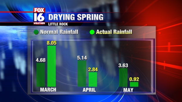
Spring for Central Arkansas started out wet, but is ending up quite dry. March was a wet Month with over 8 inches of rain recorded in Little Rock, but rainfall was below normal in April and so far May has been bone dry.


Many spots around Arkansas, including Little Rock,  have only received less than an inch of rain so far this month. Normal rainfall for the month so far is over 3 and half inches. Not only are gardens and yards getting parched due to the dry and increasingly hot weather, but fire danger is also creeping back up. Several Counties in Arkansas have enacted burn bans. The Counties shaded in red are under burn bans as of Wednesday.


Faulkner, Perry, Conway, Cleburne, Van Buren and Searcy Counties are among those now under burn bans.  Breezy conditions Thursday will add to the fire danger, along with temperatures topping 90 degrees.
The latest U.S. Drought Monitor data just released today shows most of Arkansas now under "Dry" conditions with moderate drought conditions for Northeast Arkansas.

Without some significant rainfall within the next couple of weeks, much more of Arkansas is likely to fall under drought conditions.

Saturday, May 19, 2012

Roasting for Riverfest

Stock up on the sunscreen and bottled water because Riverfest looks to be a sizzler for Memorial Day weekend. 


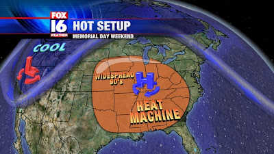
Above you can see a sneak peak at the forecast one week from today. 


An unseasonably strong upper level high pressure system will setup shop over the Ohio River Valley.  This upper level feature will cause for air to sink and heat up quickly.  Typically we see these heat machines covering the U.S. landscape in a month or two, not in late May.  That's why it will be uncomfortably hot for the unofficial start to the summer season.

(European model shows intense high pressure roughly 30,000 ft above the ground) 
 
How hot are we talking about?  Well, we're talking thermometers surging to the mid 90's with potential to hit the upper 90's in few local regions.  It really depends on the position of the high pressure.  If we end up directly underneath it we may, just may get pretty close to 100 degrees.

It sounds outrageous, but models are in a general agreement that upcoming pattern will remind us of summer.  Of course, we'll tweak the numbers once we know exactly where this heat machine develops.  Until then plan for our first real taste of summer real soon.  

Thursday, May 17, 2012

Summer Outlook

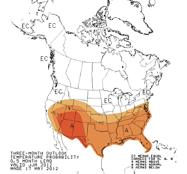
Several reports have come out recently about a forecast for an unusually hot Summer across a large part of the U.S., but seasonal forecasts can be tricky to interpret. The Climate Prediction Center, which issues long range forecasts, does not typically outright call for above or below normal temperatures or precipitation in seasonal outlooks. Rather, these outlooks are probabilistic in nature, meaning they refer to the chances of a hotter or colder and drier or wetter season. Below is the temperature outlook for June, July and August, which makes up the meteorological Summer season.


At first glance, it appears that the Climate Prediction Center is showing above average temperatures for most of the Southern half of the Country, but that is not really what the graphic shows. See the numbers along the lines, such as 33, 40 and 50? These represent probabilities, not temperatures or temperature anomalies. The orange area represents a probability of greater than 33% of a warmer than average Summer. The white area represents Equal Chances, that is what the "EC" stands for. This does not mean a forecast for an average Summer, but rather that the chances of a hotter, cooler, or normal Summer are all the same. Notice that much of the Southeast is in the 40 to 50 range for the probability of a warmer than average Summer, which means the combined chance for an average or below average summer is still over 50%! Parts of the Southwest are in the over 50% probability area, which means the combined chance of an average or below average Summer are less than half. In this case the forecast is directly for a warmer than average Summer, but the area is relatively limited.

According to the forecast, Arkansas has just over a 40% chance of warmer than average Summer. The graph below breaks down the probability distribution for the region than includes Central and Southern Arkansas as well as Northern Louisiana.


There is a lot of information in the graph, but what it means is that the chance of a warmer than average Summer calculates to 42.2% based on the forecast. The chance of an average Summer is 34.4% and the chance of a cooler than average Summer is 23.2%. The combined chance of an average OR below average Summer is 57.8%. If I told you there is a 58% chance that the Summer will NOT be hotter than average, would you interpret that as me saying I expect hotter Summer than average? I didn't think so! This is the nature of probabilistic forecasting, though. There is so much uncertainty in long range forecasting it is necessary to communicate the confidence level of the forecast.

The outlook for Summer precipitation is even less clear, with equal chances of a dry, wet or average Summer all near equal chances for most of the Country, with only a somewhat higher than average chance of a dry Summer for the Northwestern U.S.

Wednesday, May 16, 2012

2012 Annular Eclipse


An annular solar eclipse takes place this weekend, and will be visible from parts of the United States. Before you get too excited, Arkansas will not be the ideal place to the view the eclipse as the sun will go down prior to the eclipse reaching its maximum. The eclipse of May 20th 2012 is called an Annular eclipse because the size of the moon will appear relatively smaller compared to the sun. Below is an example of what an annular eclipse looks like at its maximum.


Note the ring of light around the edges. This is different from a Total solar eclipse in which the moon completely covers the sun. This also should not be confused with a Partial eclipse, in which the moon is not directly in front of the sun. The path of the annular eclipse begins in West Texas and stretches across the Pacific Ocean into Japan and China. The red line on the image below indicates the Center of the path of the annular eclipse and the blue lines show the boundaries. A partial eclipse will be visible far outside these boundaries


The green marker indicates the maximum of the annular eclipse, which in this case means the moon will cover about 97% of the visible sun. Within The United States, parts of the Southwest and West Coast will experience the best viewing. People in places as close as Lubbock, Texas will get a great viewing of the eclipse.


Farther East, the sun goes down before eclipse gets close to the maximum. It will be possible to see a partial eclipse even from Central Arkansas, but the sun will already be very close to the horizon when it starts.


As for Little Rock, a partial eclipse begins at 7:30 PM Sunday, with the sun only about 6 degrees above the horizon. This means the sun will already appear down for most of us unless you are looking at the sunset from a high vantage point with no obstructions such as a hill top. The eclipse reaches its maximum in Central Arkansas at around 8:30 PM, and with 86% of the sun covered, it would look quite impressive IF it was during the day! The sun sets below the horizon at 8:09 PM Sunday in Little Rock, well before the maximum. Even though conditions are far from perfect, enough of the sun will be covered to make for quite an interesting looking sunset if you have the right view. Keep in mind that even though the sun will be very low in the sky, you should not stare directly at it.
The next partial eclipse visible from Central Arkansas will be October 2014, but if you want to see a total eclipse you will be waiting until April 2024

Images Courtesy of NASA

Tuesday, May 15, 2012

Hurricane Season Starts...for the Pacific

Not many people know this, but today marks the beginning of the hurricane season for the Eastern Pacific.  Coincidentally, there is a tropical storm spiraling over 600 miles southwest of the Mexican border.  The tropical storm named Aletta won't do much to leave an impression on the U.S. or the meteorology community for that matter.


Yet, this does shed light on the next cycle in our weather pattern - hurricane season.  I may be jumping the gun here talking about the tropics but our spring storm season hasn't amounted to much.  I mean the upper level jet stream has straddled the northern border for numerous weeks and the lack of strong disturbances is quite odd for this time, so why not focus on the tropics briefly...

Looking ahead, I glanced at several resources (water tempreature, ENSO cycles, etc..) and a couple hurricane forecasts posted from the Colorado State University.  Generally speaking, the Atlantic Hurricane Season looks average to below average.


The meteorologists who cheer for Cam the Ram suggests roughly 10 named storms in the Atlantic and 4 hurricanes taking shape.  In addition to the sub-par numbers, the Colorado State forecast suggest only a 42% of a strong hurricane hitting the U.S. this year.  That's pretty comforting to know this far out.

The basic reasoning behind these numbers lies in the slow rise to an El NiƱo phase and the prediction of a cooler than normal temperatures around the tropics of the Atlantic.

You know and I know you can't put a lot of stock in these forecasts.  We'll just have to see if we get by another part of the year where we can avoid these weather disasters.  For some reason my gut is telling me we may not be so lucky.


Monday, May 14, 2012

WEA capable devices


VERIZON
  • Droid X by Motorola
  • Droid 2™ by Motorola
  • Droid 2 Global
  • Droid Pro by Motorola
  • Droid RAZR by Motorola
  • Droid RAZR MAXX by Motorola
  • Motorola Bionic LTE by Motorola
  • LG Cosmos™ 2
  • LG Revere™
  • LG Enlighten™
  • Lucid™ by LG
  • Verizon Jest 2
  • Samsung Convoy™ 2

 SPRINT
  • HTC EVO™ 3D
  • HTC EVO™ Design 4G
  • LG Marquee™
  • Samsung Galaxy S™ ll, Epic™ 4G Touch
  • Samsung Trender™
  • Samsung Transform™ Ultra
  • Sanyo Innuendo™
  • Sanyo Vero™ by Kyocera
  • Kyocera Milano™
  • Kyocera DuraCore
  • Kyocera DuraMax
  • Kyocera Brio™ 

T-MOBILE
  • LG DoublePlay
  • Nokia Lumia 710
  • T-Mobile® myTouch
  • Samsung Galaxy S® Blaze 4G
  • T-Mobile® myTouch 4G
  • HTC® One S

ATT
  • Samsung Galaxy SII (SGH-i777)
  • Samsung Captivate Glide (SGH-i927)
  • Motorola Atrix 2 (mb865)

Extreme Weather Texts


Your looking at a message that could pop up on your phone very soon.  Wireless carriers and the government are working together to launch weather text alerts to your cellphone. 

According to USA Today and other various sources, the Wireless Emergency Alerts (WEA) should begin late this month in certain regions. It's hard to say if we'll see it immediately, but it looks as though it will be arriving sooner than later.

This is not a new initiative available to the public.  FOX 16 provides the very same service if you sign up on our website.  What sets this text alert apart is that it will be coming directly from the National Weather Service, not from our station.

If you're wondering, the alerts like the one shown above, will only be issued for life-threatening events such as tornadoes, flash floods, hurricanes, typhoons, tsunamis, dust storms, extreme winds, blizzards and ice storms.  No watches or advisories will be sent to your phone.


The National Weather Service say the WEA system will send out warnings based on location.  Thus, if you're traveling you'll receive an alert only for that region.  There will be no charge for these special texts and no sign up forms.

Several cell phone carriers are on board with the idea such as AT&T, T-Mobile, U.S. Cellular and Verizon Wireless.

And it appears there will be more innovation in the coming years from the NWS.  A new web design is in the works for their homepage (http://preview.weather.gov) and more involvement with social networks.  Time will tell how these pieces all come together in the future.


Monday, May 7, 2012

Welcomed Cool Down

May started out very toasty and humid.  I mean the A/C was running non stop through all hours of the night.  Temperatures we're constantly reaching the 80's or 90's every single day. It seemed like we were going to skip spring all together and jump right into the summer heat.  However, in the not too distant future, a cold front is going to save the day and bring us back to reality.


As this front trickles down south of us Tuesday and into Wednesday morning, temperatures will finally take a chill pill.  Highs will very nice and comfortable with numbers in the upper 70's.  That sounds nice but the best part about the weather pattern later this week is the overnight lows slipping to the mid 50's.  In other words, we'll get another opportunity to open the windows at night to cool off before the big time summer heat emerges next month.


So take advantage while you can because sooner or later we'll be in the triple digits before you know it.

Friday, May 4, 2012

A Dry Toad Suck Daze

Yeah, you read the headline right.  Instead of being drenched in rain showers and finding an umbrella, Mother Nature will provide a dry pattern for Toad Suck Daze.  Before you go to the Conway event, you have to realize that there is a small price to be paid though for all of this non-wet weather.


As the forecast graphic shows we've got summer-like heat coming this weekend.  That may not sound like a problem but when you consider all the outdoor events, you may be asking yourself several times where can I get some water.

There is a 5k/10k run starting at 8 a.m. on Saturday with a bicycle race around the high school on Sunday. Both events will be difficult on the racers and will need all the fluids they can get. Throw in a few fun concerts as well.


Not only will the thermometers spike up to the low 90's but the humidity will make it feel much warmer.  So, in reality, it will feel like we're roasting in the mid 90's on Saturday and Sunday.

All in all, keep this in mind when you're heading out this weekend.  Have plenty of water with you and DON'T FORGET THE SUNSCREEN.


Rain Possible for Toad Suck

Well, it wouldn't be a Toad Suck Festival without a chance of rain right?  Earlier this week we thought  this weekend would be dry and toasty.  It's still going to be very warm, there's no doubt about that, but there is a small disturbance that might bring us a small chance of rain on Saturday.


In the near future, a weak upper level impulse will march in from Oklahoma.  As this mini wave runs over our region late tonight and tomorrow, there could be enough lift to sustain a couple isolated showers or thunderstorm. 


(One weather model showing a few showers over Central Arkansas late tonight)

 
 (Same weather model showing a few isolated showers in NE Arkansas Saturday afternoon)

This won't ruin your Toad Suck Daze event...not by a long stretch.  In fact, the best chance of rain (20%) will come in this evening and early tomorrow morning.  Overall, don't be surprised if you run into a renegade shower while you're out to the festival.  Who knows, maybe a nice downpour will be nice considering all of the heat planned for the weekend.