
While the weather will remain hot and steamy in Arkansas, our focus is slowly turning over toward the Yucatan Peninsula.

A tropical low has rapidly formed in this area in the last 24 hours...and it's gaining strength. Clusters of thunderstorms continue to develop around the core of the system which is a clear sign that it is organizing.
Why does anybody care? Well, it could be our first tropical cyclone to strike the U.S. this year.
As you can see from the image above, majority of the models want to take the storm complex through the southern half of the gulf and turn it toward Texas. Given the future position of the upper level high this track seems correct. Right now, I don't favor the climatology models which have it striking just south of Galveston and north of Corpus Christi. I'm more incline to follow the dynamical models (HWRF) which shove the tropical system through the southern tip of the Texas. Of course a lot can change in the given days.
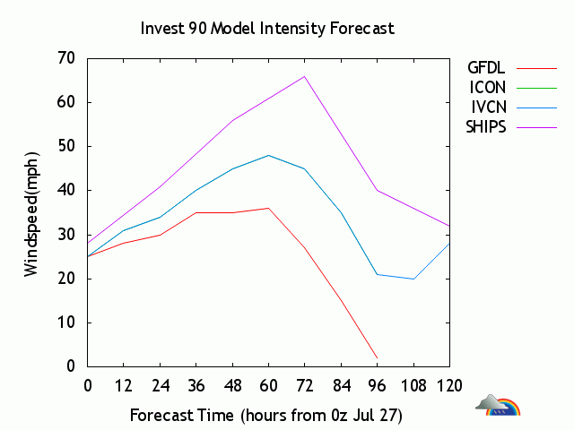
Also, a couple intensity models want to ramp this system to a tropical storm within 48 hours. That certainly seems possible given the lack of shear and favorable environment ahead.
All in all, this is exactly what the Lone Star State is looking for in the future. If this system can hold together and not become a full fledge hurricane this may be the drought buster they desperately need. As for Arkansas, we'll hardly see or feel anything from this upcoming disturbance, if it holds together.
Stay tuned I'll have more updates on the blog about the tropics and give you more details on another heat wave taking shape across the Mississippi Valley.
-------------------------------------------------------------------------------------------------------------
No comments:
Post a Comment