Friday, July 29, 2011

Don to bring drought busting rains for TX? Not so fast...


The track for Tropical storm Don has trended South over the last 24 hours. In addition, Northerly shear has kept the heaviest rains South of the center of circulation. The end result is that only Deep South Texas is likely to get any beneficial rainfall. Drought stricken San Antonio may see little if any rainfall. The above graphic shows the forecast rainfall from The Hydro-meteorological Prediction Center showing an area of 3"+ of rainfall through Sunday mainly South of Corpus Christi. Most of Texas remains in exceptional drought, with little relief in sight.


As for Arkansas, most of the State is now in moderate drought with the driest conditions across Southern areas. Although a few showers will be around the next couple of days, the rainfall will not be widespread enough to put any meaningful dent in the drought.


More Clouds and Better Rain Chances

TODAY: This morning we're waking up to find a cloudy sky overhead. As the day moves along, we'll watch the clouds break up and reveal some sunshine at times.  Meanwhile, temperatures will spike up to the low 90's in many locations.

                                               (RPM model showing scattered storms in Arkansas by afternoon)

Eventually, with enough daytime heating we'll witness a few scattered showers and storms develop this afternoon.  Most of the high resolution models highlight central/southern portions of the state with the greatest potential of seeing a brief downpour and I tend to agree with their assessment.

WEEKEND: The same type of weather we're seeing today we'll be on the way for Saturday.  We'll begin with clouds and temperatures in the upper 70's.  The sun will come out later in the day while temperatures attempt to climb to the mid 90's.  With enough heating and a weak disturbance aloft, we'll have a decent shot at a few isolated storms developing in Central Arkansas.  Sunday on the other hand, will feature more sunshine and hotter temperatures in the mid-upper 90's.  Rain chances will also plummet with a higher pressure building in the upper levels of the atmosphere.


TROPICAL STORM DON: As I mentioned earlier in the week, we'll have our first tropical storm hit the U.S. very soon.  Tropical Storm Don continues to hover around 50 mph and is NOT expected to strengthen before he hits land around the southern part of Texas late tonight.   Unfortunately the bulk of the rain will miss most of the Lone Star State over the weekend.

ANOTHER TROPICAL SYSTEM BREWING:  Out in the Atlantic we're watching another tropical wave shaping up east of the Lesser Antilles.  A couple hurricane models want to intensify this system into a hurricane in a couple days so we'll keep on it for the time being.

Tuesday, July 26, 2011

Close Eye on the Tropics


While the weather will remain hot and steamy in Arkansas, our focus is slowly turning over toward the Yucatan Peninsula.


A tropical low has rapidly formed in this area in the last 24 hours...and it's gaining strength.  Clusters of thunderstorms continue to develop around the core of the system which is a clear sign that it is organizing.

Why does anybody care?  Well, it could be our first tropical cyclone to strike the U.S. this year.

As you can see from the image above, majority of the models want to take the storm complex through the southern half of the gulf and turn it toward Texas.  Given the future position of the upper level high this track seems correct.  Right now, I don't favor the climatology models which have it striking just south of Galveston and north of Corpus Christi.  I'm more incline to follow the dynamical models (HWRF) which shove the tropical system through the southern tip of the Texas.  Of course a lot can change in the given days.


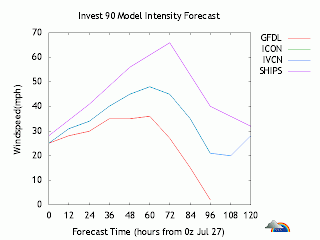
Also, a couple intensity models want to ramp this system to a tropical storm within 48 hours.  That certainly seems possible given the lack of shear and favorable environment ahead. 

All in all, this is exactly what the Lone Star State is looking for in the future.  If this system can hold together and not become a full fledge hurricane this may be the drought buster they desperately need.  As for Arkansas, we'll hardly see or feel anything from this upcoming disturbance, if it holds together.

Stay tuned I'll have more updates on the blog about the tropics and give you more details on another heat wave taking shape across the Mississippi Valley.


-------------------------------------------------------------------------------------------------------------

Monday, July 25, 2011

An Update Long Overdue

I'm back!  If you've been wondering about the lack of updates on the weather blog...well...don't worry.  The reason for the absence revolves the fact that I got married. Obviously I was occupied with that main event in my life so that explains the delay.

Now that I'm back from the honeymoon, let's get back to bussiness.  While I was gone there wasn't a whole lot that changed in the weather pattern in Arkansas.  It was hot and we saw a few isolated storms roam over the landscape.  The major topic that everyone talked about last week was the massive heat wave that broke out in the Central and Eastern portions of the U.S.  Jeff and I saw this pattern well out in advance so it's not shocking to hear that cities got to experience heat index values in the 120 range.

Onto this week...

TODAY:  A weak upper level disturbance is rushing in from the west.  While that is taking place, we had to endure a good amount of daytime heating earlier today.  With these two elements coming together in the Natural Sate, we have seen thunderstorms develop over portions of Central and Southern Arkansas.  These storms will be brief.  They'll carry heavy downpours, lightning and gusty winds.  Above all else, the cloud cover and rainfall will help temperatures cool down to the 80's and upper 70's.


TONIGHT: Storms will quickly fade and we'll be left some lingering clouds.  Temperatures will stumble down to the mid to upper 70's.

TUESDAY-THURSDAY:  The atmosphere will settle down over Arkansas and it will stay hot.  Temperatures will spike up to the upper 90's if not 100 degrees with a few clouds mixing with the blazing sunshine.

FRIDAY-WEEKEND: Long range models continue to hint at another disturbance coming in from the gulf.  If it does manage to get here we may see a few pop-up afternoon storms as we approach the weekend.  The chances are not too high here so you can still plan on doing your outdoor activities if you can survive the heat.


                                                (GFS weather model showing evening storms for Saturday)


NEXT WEEK: We're already getting indications that another heat wave maybe brewing for early next week.  Another dome of high pressure is expected to develop aloft near Kansas and Northwest Arkansas.  Thus, forcing temperatures to stay in the triple digits...and rain chances to remain non-existant.  Hopefully we'll get a different output in the coming days.

                                         (European model showing strong high pressure in the mid levels early next week)


That's it my friends.  I'll have more updates this week.


-------------------------------------------------------------------------------------------------------------

Sunday, July 10, 2011

Hottest Day So Far


REST OF TODAY:  The weather is extremely hot with temperatures in the triple digits and heat index values climbing above 110 (look at the image below...I know right).  It is just not a good idea to be outside for more than a couple minutes.  The sunshine will remain large and in charge for the rest of the late afternoon and will keep temperatures in the triple digits for a couple more hours.

                                               (The heat index recorded at 3pm today)

TONIGHT: The sky will be clear and that will help radiate out all the heat we received earlier today.  Although, with the moisture content being fairly high, we'll only feel temperatures cool off about 20 degrees tonight.  That means overnight low's will once again fall down near 80 degrees.  Yuck.

TOMORROW:  Monday will look and feel almost identical to what we're going through today.  With a relatively strong ridge overhead, temperatures will sky rocket to the triple digits once again while the sunshine beats down on the state.

LATER THIS WORK WEEK:  Weather models continue to hint at a subtle change by Wednesday and beyond.  The upper level ridge will rotate a weak disturbance toward Arkansas and on top of that the ridge will weaken in the process. In other words, we're looking at a shot of afternoon showers and thunderstorms soon.  Plus temperatures won't be as hot in the 90's.

As I continue to review all of the long term models, it's quite apparent that Northern/Eastern Arkansas has the greatest chances at seeing the accumulation of rain.  I'll continue to monitor this change in the weather pattern and let you know when we can a little relief from heat soon.

Until then have an awesome rest of your weekend and stay cool as best you can!


-------------------------------------------------------------------------------------------------------------

Friday, July 1, 2011

Back to the Summer Heat

Earlier I promised to talk about the tropical system brewing in the Bay of Campeche.  Well, I'm sure you've all heard by now that it became our first tropical storm of the Atlantic hurricane season (Arlene).  It didn't do much except dump a good amount of rain on the eastern coast of Mexico.   I apologize for the lack of updates during the middle of the week.  I do have an excuse though...I was moving into a new home.

Now that I have that out of the way let's see what our weather will be like as we think about lighting those fireworks this weekend.
 
TODAY:  Similiar to Thursday we'll see plenty of sunshine and feel temperatures warm up to the mid upper 90's.  Due to Tuesday's soaking, we'll likely not hit 100 degrees today.  Nonetheless, it will still be hot outside so make sure to be careful if you're outside for an extended period of time.

4TH JULY WEEKEND: An upper level high will be in the process of breaking down. Although it will be weaker, the upper level system will still be near we'll continue to have hot, dry weather with temperatures in the upper 90's.  Some places will hit 100 on Saturday and Sunday.

4TH OF JULY: The ridge (upper level high) will migrate west allowing us to see pulse thunderstorms develop.  For those who don't know, pulse thunderstorms are ones that pulse up quickly due to daytime heating/moisture in the atmosphere.  Without the high pressure to suppress the possibility of storms we'll put in a small chance of rain for Independence Day.  The good news to take from all of this is that if a storm actually does managed to go up it won't last long and will likely fizzle out by the time you see fireworks.

NEXT WEEK:  Similar to the 4th, the forecast won't alter that much.  We'll be dry and hot most of the day but there will be moments where a few isolated, quick thunderstorms could develop late into the day.


That is it my weather friends.  Enjoy you're extended weekend!