Sunday, April 29, 2012

Summer Heat Arrives Early

After enduring a mild April, Little Rock and Central Arkansas is about to face the summer heat a little early this May.


The jet stream will lift up near the northern part of the U.S. late this work week and into the first weekend of May.  Meanwhile, a big area of high pressure will develop aloft near the Texas and Mexico border.  Inevitably this setup will cause our temperatures to constantly sky rocket to the low 90's during the afternoon.  In case you were wondering, these numbers will rival a few record highs down the road.

We're not talking about triple digit heat so don't throw in the towel on our weather pattern just yet, but I don't except this humid air or warmth to leave Arkansas anytime soon.

On the bright side, the Toad Suck Daze event won't be a complete wash out like it normally is this time of year.  Although keep in mind, if you plan on running the 5k/10k Tadpole Trot you're in for some brutal weather conditions ahead.

Wednesday, April 25, 2012

A Look Back at the Vilonia Tornado

One year ago today marked the beginning of an incredible outbreak of tornadoes across the Southern Plains.  This type of event was unprecedented and rivaled the Super Outbreak of April 3rd and 4th back in 1974.


The great outbreak of 2011 included parts of Arkansas where a memorable EF-2 tornado tore through the heart of Vilonia.  The twister took shape east of Mayflower and quickly developed into a large tornado around 7:30 p.m.  Our HD Pinpoint Radar detected the circulation immediately and was best signature I had ever seen in my meteorology career. Initially we thought the tornado was on a much larger scale than it was reported.  It certainly looked impressive to us in the weather center.


Looking back, the tornadic storm was warned on for over 15 minutes before getting close to the small town.  Despite the lee time, four lives were loss in the process.

We remember those who were affected and strive to improve the techniques to detect these powerful storm systems.  Luckily for us our weather looks oddly quiet for this time of year.  Hopefully we can keep this going for rest of spring.

Monday, April 23, 2012

Mid Week Warm Up

Cool air circulating around the huge storm system responsible for bringing a Spring snow storm to parts of the Northeast has kept temperatures below average across Arkansas early this week.  High temperatures remained in the 60s Monday for most of Central Arkansas, but a significant warming trend is in store over the next couple of days.


A strong Southwest flow will develop by the middle of the week, helping to boost temperatures well into the 80s. Wednesday will turn quite breezy as winds increase out of the Southwest gusting over 30 MPH at times during the afternoon.


A dome of very warm air will develop across The Southern and Central Plains by mid-week, with temperatures likely cracking the 90 degree mark over parts of Texas, Oklahoma, and Kansas. It is quite possible that parts of Western Arkansas may also approach 90 by mid-week. Below are computer model forecast temperatures for 3 PM Wednesday.


Warm temperatures are likely to last through the end of the week, until a cold front approaches over the weekend.

Sunday, April 22, 2012

Winter's Back...in the Northeast

There is it much to say about our weather pattern in Central Arkansas.  It's pretty quiet around here and it stay that way for several days...Meanwhile, if you haven't heard, things are getting pretty hairy up in the Northeast section of the U.S.


A vigorous upper level low is heading straight for the Northeast Coastline at this hour.  Meanwhile, on the tail end of this system there is a large swath of precipitation that is about to run into a pocket of bone chilling cold air.  In fact, the air is so cold on the western edge of this system that rain will inevitably switch over to heavy snow.  You read right, SNOW.  Accumulations are difficult to pin down, as they are always are, but leading models suggest, get this, a good swath of 4-8" of snow for Western Pennsylvania and Western New York.  Some local spots just south of Buffalo may accumulate more than foot.  Hard to imagine right?  In late April? You just have to shake your head at Mother Nature on this one.


What's interesting about all of this is that this is exact same disturbance that brought the heavy rain on us Friday.  It seemed like any other system to Arkansas but the moment it picked up steam in the Gulf Coast and rushed to the Northeast is where it's major impact will be felt.

Needless to say you won't be getting a flight on time to Pittsburgh or Buffalo tomorrow.

Thursday, April 19, 2012

Friday Cold Front

A cold front swinging through the State Friday will bring showers and a few thunderstorms, especially during the afternoon.


The front will push through during the early afternoon hours, but rain and some isolated thunder will continue behind the front lasting well into the evening. Temperatures behind the front will fall from near 70 around Noon to the upper 50s to lower 60s by the early evening hours. The chill will be enhanced by increasing Northerly winds during the evening. Our computer model shows lingering rain across Central Arkansas at 8 PM with the actual cold front clearing Eastern Arkansas.


Most of the state will receive a healthy dose of some rainfall, but amounts are not expected to be enough to cause any flooding problems. Below is our high resolution computer projection of rainfall totals through 11 PM Friday.


Severe weather is unlikely with this storm system, partially due to the lack of moist Gulf air and lack of heating ahead of the front. Below is today's outlook for severe weather from The Storm Prediction Center.


Showers will come to end Friday night as the front moves away, but a cool breeze will continue into Saturday morning.

Monday, April 16, 2012

van buren tornado graphics

Below are the maps showing the location of the tornado found in Van Buren County


Saturday, April 14, 2012

Severe Weather Sunday

Sunday is a FOX16 News Severe Weather Alert Day. The strong system that spawned numerous tornadoes across the Plains Saturday will shift East Sunday spreading storms from the Midwest through Arkansas and into parts of Texas and Louisiana


The Storm Prediction Center has issued a SLIGHT risk for most of Arkansas with enhanced threat for especially strong storms capable of producing damaging wind gusts and large hail.


Isolated tornadoes are also possible, however, a widespread tornado outbreak similar to what happened over Oklahoma and Kansas Saturday is unlikely.  The storms will approach as a line of storms, rather than individual super-cells. Although the tornado threat may not be particularly high, damaging winds are likely with some of the stronger segments along the line.


As for the timing , the line of storms will move into Western and Northwest Arkansas during the early afternoon hours.


Storms will reach Central Arkansas during the evening hours. Notice how the storms will be arranged along a continuous line, indicating that straight line winds will be the predominant threat.


The main risk for severe weather across Central Arkansas will be between about 5 PM through around Midnight. Our computer model shows the storms moving through the metro area around 9PM, although some of the other models bring the storms through a bit sooner.


Storms will push into Eastern Arkansas late Sunday night into early Monday morning. The storms will tend to weaken as they move East with the loss of daytime heating.


Friday, April 13, 2012

Weekend Storms

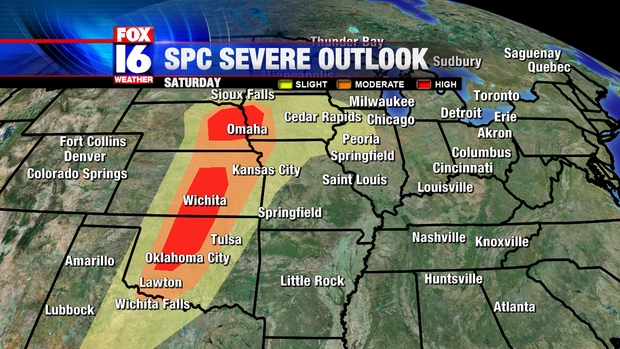
A strong area of low pressure ejecting into the Plains this weekend will trigger widespread storms through the weekend. The Storm Prediction Center is forecasting a major outbreak of severe weather with a high potential for tornadoes for parts of The Plains States on Saturday. The SPC has issued a rare day 2 HIGH risk area for parts of Oklahoma, Kansas, Nebraska and Iowa valid for Saturday.


As a matter of fact, the Storm Prediction Center has only issued a high risk a full day in advance only ONCE prior to today. The setup is a classic scenario for a tornado outbreak along Tornado Alley as a strong upper air disturbance pushes out of the Rockies and interacts with warm and humid air from the Gulf of Mexico. A very strong jet stream will create significant wind shear ahead of the cold front, allowing storms that do develop to quickly begin to rotate. The warm, moist air will aid to sustain the storms.


The severe risk transitions East as the frontal boundary pushes toward Arkansas on Sunday. The Storm Prediction Center has issued a SLIGHT risk for parts of Arkansas Sunday. The slight risk does include an area of an enhanced risk of severe weather shaded in purple, where there may be the potential for especially strong storms.


The main risk with Sunday's round of severe weather will be very strong, damaging wind gusts, although a tornado threat may exist as well. It is still too soon to determine what kind of tornado potential will develop, but that will become more clear as we progress through the weekend.

As for the timing, storms will approach Western and Northwest Arkansas by Sunday afternoon.


The line of storms will consolidate Sunday evening as it pushes into Central Arkansas. The main risk for sever weather in Central Arkansas will be mainly between 5 PM and Midnight.


Storms will continue into Eastern and Southeast Arkansas by early Monday morning, however the severe risk will diminish somewhat.

Tuesday, April 10, 2012

Active Weather Ahead

We're almost to the half way point of the work week and we're still getting signs that severe weather is coming to parts of the U.S.


In the last blog post, I mention that our weather pattern was going to change significantly this upcoming weekend.  I was pretty vague on the details but we saw the pattern shifting.  In case you missed it, our flow is going to turn more out of the southwest soon, which will lead to warmer temperatures and muggy conditions.  Plus a deep low will form in the four corners region. This setup you see in the image above may not mean a whole lot to you but to the meteorology community it means we have to gear up for severe weather.

The first round of severe weather is expected to happen late this work week.  The Storm Prediction Center in Norman, Oklahoma has been hinting at this event for several days now. Fortunately the storms look to miss Arkansas and stay in Oklahoma on Friday.  However, as the cold front and low pressure system inch closer to us early next week, we may not be so lucky.

     (GFS model showing severe storms Monday evening in Western Arkansas.)

We'll continue to monitor future computer models and see how the weather unfolds in the next few days.  If there is more evidence for severe weather coming next week we'll be sure to let you know about it on the FOX 16 weather blog.  Until then enjoy the mild weather and stay tuned.

Sunday, April 8, 2012

Strong Storms on the Horizon?

This April has already had it's fair shares of ups and down but this week looks to be pretty much what you would expect for this time of year. We'll see a northwest flow aloft give us a few bouts of showers while other days will be dry with temperatures in the 70's.

                            (Roughly 20,000 ft above us there will be winds coming in from the northwest)

Next weekend seems interesting because our flow will change from a northwest one to more of a southwest one.  That can mean only thing around this time of year...active weather ahead.

                                     (One week from today, the winds switch to the southwest at 20,000 ft)

In due time, our thermometers will race back up to near 80 degrees by next Saturday and Sunday.  Also, moisture from the Gulf of Mexico will spill back into our region.  It will only be a matter of time before a disturbance sets off strong thunderstorms with these conditions in place.  The question is where and when will it all of it go down?

                                   (GFS model showing strong system bringing strong storms April 16th)

Early indications point to an active pattern sometime one week from now.  The details are hard to pin down but we do know that a disturbance in the form of a cold front could trigger severe thunderstorms next week Monday or Tuesday.  The main target runs from Texas, Oklahoma and through Missouri.

                               (SPC highlighting Oklahoma and Kansas with possible severe weather one week from now.)

We may not know a whole lot of details at this hour but we do know that our weather is going to get a lot warmer and active soon. Make sure to stay tune to the FOX 16 weather blog for more updates on this development.

Sunday, April 1, 2012

Back to a Cooler Pattern

After enduring the warmest March on record, it appears most of this April will be about the same...or will it?


Several weather models are suggesting a significant change to the weather pattern - one that involves a much cooler scenario for the Great Lakes and parts of Arkansas.

First, I know you're wondering when will this happen?  Sooner then you think.  It seems like the general agreement is sometime early next week. If I had to guess right now, I would say next week Tuesday could be the day where we'll get a major break from the unseasonable warmth.

                     (European weather model showing a deep trough to our east, which means cooler days are ahead.)

The shift to this cooler weather is a result of the flow in the atmosphere around 20,000 feet above your head.   If you look there, you'll see the jet stream may buckle soon and create a trough over the eastern portion of the U.S. (look at the picture above for reference). In other words a cold front might slip into the state and carry a good amount of chilly air back into Arkansas - we're talking about highs reaching the 60s and low 70s while overnight lows dip back to the 40s.  Sounds nice, right?

I want to say that nothing is set in stone quite yet but the trend is for us get back to normal around here...so don't be surprised if you have to bust out the jacket a couple times next week.